Washington State Park
| Washington State Park | |
| Missouri State Park | |
 Stone shelter overlooking the Big River valley | |
| Country | United States |
|---|---|
| State | Missouri |
| County | Washington |
| Elevation | 673 ft (205 m) [1] |
| Coordinates | 38°05′00″N 90°41′18″W / 38.08333°N 90.68833°WCoordinates: 38°05′00″N 90°41′18″W / 38.08333°N 90.68833°W [1] |
| Area | 2,147.57 acres (869 ha) [2] |
| Established | 1932 [3] |
| Management | Missouri Department of Natural Resources |
| Visitation | 233,424 (2017) [4] |
 Location in Missouri | |
| Website: Washington State Park | |
|
Washington State Park Petroglyph Archeological Site | |
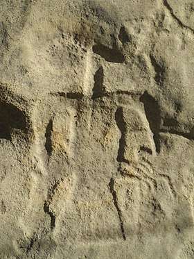 An eagle petroglyph at Washington State Park | |
| Nearest city | Fertile, Missouri |
| Area | 25 acres (10 ha) |
| NRHP reference # | 70000352[5] |
| Added to NRHP | April 3, 1970 |
|
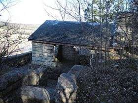
Washington State Park CCC Historic District | |
 Washington State Park CCC pavilion | |
| Nearest city | Potosi, Missouri |
| Area | 710 acres (290 ha) |
| Built | 1934 |
| Built by | Civilian Conservation Corps |
| Architectural style | Rustic |
| MPS | ECW Architecture in Missouri State Parks 1933-1942 TR |
| NRHP reference # | 85000517[6] |
| Added to NRHP | March 4, 1985 |
Washington State Park is a public recreation area covering 2,147 acres (869 ha) in the central eastern part of the state of Missouri located on Highway 21 about 14 miles (23 km) northeast of Potosi on the eastern edge of the Ozarks. The state park is noted for its Native American rock carvings and for its finely crafted stonework from the 1930s.[3]
Stone carvings
The carvings, or petroglyphs, carved in dolomite rock, are believed to have been made around 1000 to 1600 C.E. and to give clues to the lives of the prehistoric Native Americans who once inhabited this part of Missouri. It is also believed that the park served as ceremonial grounds for these Middle Mississippi people who were related to the builders of the Cahokia Mounds in Illinois.
Most of the carvings are of birds, arrows, footprints, turkey tracks, human figures, and various geometric shapes and patterns. The three petroglyph sites in the park are thought to be all that is left of a more extensive site. They make up almost 75 percent of the known petroglyphs in Missouri and contain over 350 symbols.[7]
The petroglyphs were listed on the National Register of Historic Places in 1970 as the Washington State Park Petroglyph Archeological Site.[5][8][9]
Stone structures
The park was built during the Great Depression of the 1930s by the African-American stonemasons of the Civilian Conservation Corps known as Company 1743.[10] Their efforts left the park with the historical stone structures that still stand today: hiking shelters, picnic pavilions, and the stones that make up the 1,000 Steps Trail.[11][12] Fourteen buildings and stone structures comprise the Washington State Park CCC Historic District, a national historic district listed on the National Register of Historic Places in 1985.[6]:482-503
Activities and amenities
Park activities include camping, fishing, canoeing, hiking, and both pool and river swimming in the Big River.[3]
References
- 1 2 "Washington State Park". Geographic Names Information System. United States Geological Survey.
- ↑ "State parks...estimated acres" (PDF). Revised Statewide Comprehensive Outdoor Recreation Plan: 2008-2012. Missouri Department of Natural Resources. pp. 142–143. Retrieved April 13, 2018.
- 1 2 3 "Washington State Park". Missouri State Parks. Missouri Department of Natural Resources. Retrieved 2013-02-06.
- ↑ "Missouri State Park Attendance 2017" (PDF). Missouri State Parks. February 1, 2018. Retrieved April 13, 2018.
- 1 2 National Park Service (2010-07-09). "National Register Information System". National Register of Historic Places. National Park Service.
- 1 2 Wright, Bonnie (1985). "Emergency Conservation Work (E.C.W.) Architecture in Missouri State Parks, 1933-1942" (PDF). National Register of Historic Places Inventory Nomination Form. Missouri Department of Natural Resources. Retrieved 2017-03-01. (includes photographs)
- ↑ Drew, Nancy (March–April 1993). "Ten Miles of Ozarks History". The Ozarks Mountaineer. Kirbyville, Mo.: 58.
- ↑ Neathery and Michael Fuller (January 2016). "Washington State Park Rock Art Site "A" (23WA01)". Missouri Archaeological Society. Retrieved 2017-03-01. (includes photographs)
- ↑ Neathery and Michael Fuller (April 2016). "Washington State Park Rock Art Site "B" (23WA02)". Missouri Archaeological Society. Retrieved 2017-03-01. (includes photographs)
- ↑ Cunning, John (January–February 1996). "CCC Company 1743: The Thunderbirds" (PDF). Preservation Issues. Jefferson City, Mo.: Missouri Department of Natural Resources Historic Preservation Program. Vol. 6, No. 1: 1, 6–7. Retrieved 2013-02-06.
- ↑ "Trails at Washington State Park". Missouri Department of Natural Resources. Retrieved 2013-02-06.
- ↑ Drew, p. 59. "One can only marvel at the effort it must have taken to shape the limestone blocks and then to place them on the hillside."
External links
- Washington State Park Missouri Department of Natural Resources
- Washington State Park Map Missouri Department of Natural Resources
| Wikimedia Commons has media related to Washington State Park. |

