Big River (Missouri)
| Big River | |
| River | |
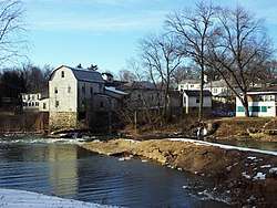 Dam at Cedar Hill, Missouri, on the Big River | |
| Name origin: French: Grande Rivière | |
| Country | United States |
|---|---|
| State | Missouri |
| Tributaries | |
| - left | Brock Creek, Clear Creek, Furnace Creek, Hopewell Creek, Blay Creek, Cabanne Course, Bear Creek, Three Hill Creek, Maddin Creek, Mineral Fork, Ditch Creek, Maupin Creek, Jones Creek, Skullbones Creek |
| - right | Sam Branch, Smith Branch, Janes Creek, Dent Branch, Cedar Creek, Mill Creek, Dry Creek (Washington County), Hayden Creek, Eaton Branch, Flat River, Cedar Run, Pike Run, Coonville Creek, Bee Run, Perkins Creek, Dry Creek (Jefferson County), Belews Creek, Heads Creek |
| Cities | Caledonia, Irondale, Park Hills, Bonne Terre, Byrnes Mill |
| Source | |
| - location | Iron County, Missouri, United States |
| - elevation | 1,300 ft (396 m) |
| - coordinates | 37°41′24″N 90°57′56″W / 37.6899°N 90.9656°W |
| Mouth | Meramec River |
| - elevation | 400 ft (122 m) |
| - coordinates | 38°28′19″N 90°37′08″W / 38.4720°N 90.6188°W |
| Length | 145 mi (233 km) |
| Basin | 955 sq mi (2,473 km2) |
The Big River is a tributary of the Meramec River in east-central Missouri. The river rises in western Iron County (37°41′24″N 90°57′56″W / 37.6899°N 90.9656°W), near the summit of Johnson Mountain and the locale of Enough; it flows through Washington County, Saint Francois County, and Jefferson County. It forms part of the boundary between Jefferson County and Saint Francois County and also part of the boundary between Jefferson County and Washington County. It empties into the Meramec River opposite Eureka (38°28′19″N 90°37′08″W / 38.4720°N 90.6188°WCoordinates: 38°28′19″N 90°37′08″W / 38.4720°N 90.6188°W), where the Meramec forms the border between Jefferson County and Saint Louis County. The river flows through Washington State Park, St. Francois State Park, and the Lead Belt mining district. The elevation of the river at its source is approximately 1,300 feet (400 m) above sea level and at its mouth about 400 feet (120 m). The length of the river is approximately 145 miles (233 km),[1] while the airline distance between source and mouth is about 56 miles (90 km). Its watershed area is 955 square miles (2,470 km2).
The river flows through the communities of Belgrade, Caledonia, Irondale, Park Hills, Bonne Terre, Morse Mill, Cedar Hill, Byrnesville, and Byrnes Mill.
Tributaries of the Big River include Flat River, Belews Creek, Turkey Creek, Mill Creek, Mineral Fork, Calico Creek, Heads Creek, Terre Bleue Creek (via Pike Run), Ditch Creek, and Jones Creek.
Character of the river
Like many other Ozark streams, the Big River has entrenched meanders; its valley is typically about half a mile wide, sometimes much narrower, and the valley is usually from 150 to 400 feet (46 to 122 m) deep. This indicates that this river formed on a plain near sea level, which give the river its meandering nature, and then was subsequently uplifted, causing entrenchment.
About 83 miles (134 km) are navigable; however, the remains of five small mill dams makes portage necessary, due to drops of several feet or high turbulence. Otherwise, the river is gentle for canoeing, with a Class I difficulty rating. Public parks are adjacent to most of these dams, and are popular fishing spots. Due to steady infeed of springwater, this river is navigable in all seasons.
Major pollution sources near Park Hills are due to historic mining activities, which including erosion from mine tailings piles and leaking mine dams.
Major gamefish commonly found in the river include largemouth bass, smallmouth bass, spotted bass, rock bass, longear sunfish, bluegill, channel catfish, flathead catfish, and redhorse suckers.
History
The name "Big River" is a translation of the French Grande Rivière.[2]
According to the National Weather Service, the maximum flood stage of the Big River at Byrnesville occurred on August 21, 1915, and was 30.20 feet (9.20 m), with a flow of roughly 80,000 cubic feet (2,300 m3) per second. Flood stage at Byrnesville is 16 feet (4.9 m). The lowest flow measured, 25 cubic feet (0.71 m3) per second, was recorded on August 30, 1936. The average annual discharge here is 862 cubic feet (24.4 m3) per second. August is the month with the lowest average flow, while April has the highest average flow.
See also
References
- ↑ U.S. Geological Survey. National Hydrography Dataset high-resolution flowline data. The National Map Archived 2012-04-05 at WebCite, accessed May 13, 2011
- ↑ "St. Francois County Place Names, 1928–1945". The State Historical Society of Missouri. Archived from the original on June 24, 2016. Retrieved November 27, 2016.
External links
- Big River canoeing information
- More Big River canoeing information
- Big River flood stage information
- A Paddlers Guide to Missouri
- Big River Watershed Inventory and Assessment, from the Missouri Department of Conservation