| [3] |
Name on the Register |
Image |
Date listed[4] |
Location |
City or town |
Description |
|---|
| 1 |
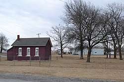
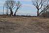
Bois d'Arc Cooperative Dairy Farm Historic District |
|
September 27, 1991
(#91001407) |
MO J near junction with Bois d'Arc Rd.
38°51′40″N 93°09′16″W / 38.861111°N 93.154444°W / 38.861111; -93.154444 (Bois d'Arc Cooperative Dairy Farm Historic District) |
Hughesville |
|
| 2 |
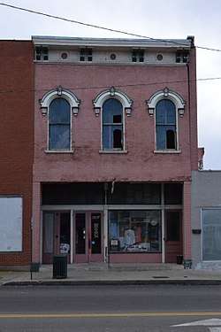
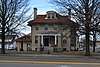
Building at 217 West Main Street |
|
October 24, 1996
(#96001189) |
217 W. Main St.
38°42′39″N 93°13′46″W / 38.710833°N 93.22938°W / 38.710833; -93.22938 (Building at 217 West Main Street) |
Sedalia |
|
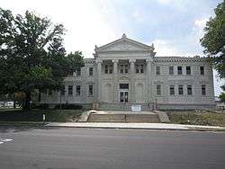
| 3 |
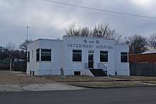
G and G Veterinary Hospital |
|
April 15, 2011
(#11000186) |
711 W. Main St.
38°42′43″N 93°14′04″W / 38.711944°N 93.234444°W / 38.711944; -93.234444 (G and G Veterinary Hospital) |
Sedalia |
|
| 4 |
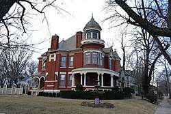
William H. Gentry House |
|
November 14, 1997
(#97001434) |
22970 Cherry Tree Ln.
38°44′38″N 93°15′31″W / 38.743889°N 93.258611°W / 38.743889; -93.258611 (William H. Gentry House) |
Sedalia |
|
| 5 |
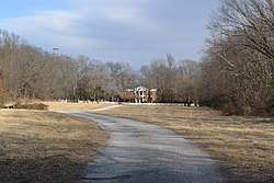
Harris House |
|
July 10, 1979
(#79001387) |
705 W. 6th St.
38°42′22″N 93°14′06″W / 38.706111°N 93.235°W / 38.706111; -93.235 (Harris House) |
Sedalia |
|
| 6 |
John T. and Lillian Heard House |
|
April 15, 2011
(#11000187) |
200 W. Broadway Blvd.
38°42′15″N 93°13′46″W / 38.704167°N 93.229444°W / 38.704167; -93.229444 (John T. and Lillian Heard House) |
Sedalia |
|
| 7 |
Hillview Cooperative Dairy Farm Historic District |
|
September 27, 1991
(#91001399) |
Junction of MO T and Hillview Rd.
38°49′41″N 93°21′29″W / 38.828056°N 93.358056°W / 38.828056; -93.358056 (Hillview Cooperative Dairy Farm Historic District) |
Hughesville |
|
| 8 |
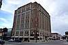
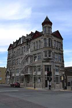
Hotel Bothwell |
|
September 8, 1989
(#89001406) |
103 E. Fourth St.
38°42′29″N 93°13′39″W / 38.708056°N 93.2275°W / 38.708056; -93.2275 (Hotel Bothwell) |
Sedalia |
|
| 9 |
C.C. Hubbard High School |
|
July 3, 1997
(#97000628) |
721 N. Osage Ave.
38°42′58″N 93°13′38″W / 38.716111°N 93.227222°W / 38.716111; -93.227222 (C.C. Hubbard High School) |
Sedalia |
|
| 10 |
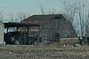
Henry Jones Farmstead |
|
December 3, 2008
(#08001129) |
17000 Hwy. EE
38°49′44″N 93°10′01″W / 38.828894°N 93.166964°W / 38.828894; -93.166964 (Henry Jones Farmstead) |
Sedalia |
|
| 11 |
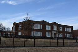
McVey School |
|
October 14, 1999
(#99001255) |
Junction of MO 50 and Rte M
38°41′59″N 93°11′23″W / 38.699722°N 93.189722°W / 38.699722; -93.189722 (McVey School) |
Sedalia |
|
| 12 |
Missouri State Fairgrounds Historic District |
|
June 28, 1991
(#91000853) |
Roughly bounded by US 65, Co. Rd. Y, Clarendon Rd. and the Missouri-Kansas-Texas RR tracks
38°41′40″N 93°15′23″W / 38.694444°N 93.256389°W / 38.694444; -93.256389 (Missouri State Fairgrounds Historic District) |
Sedalia |
|
| 13 |
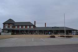
Missouri, Kansas and Texas Railroad Depot |
|
March 28, 1979
(#79001388) |
600 E. 3rd St.
38°42′28″N 93°13′14″W / 38.707778°N 93.220556°W / 38.707778; -93.220556 (Missouri, Kansas and Texas Railroad Depot) |
Sedalia |
|
| 14 |
Missouri/Sedalia Trust Company |
|
March 29, 1983
(#83001034) |
322 S. Ohio St.
38°42′28″N 93°13′41″W / 38.707778°N 93.228056°W / 38.707778; -93.228056 (Missouri/Sedalia Trust Company) |
Sedalia |
|
| 15 |
Osage Farms Type 315:13 Government Farmhouse |
|
September 27, 1991
(#91001406) |
MO J near junction with Miller Chapel Rd.
38°53′20″N 93°07′37″W / 38.888889°N 93.126944°W / 38.888889; -93.126944 (Osage Farms Type 315:13 Government Farmhouse) |
Hughesville |
|
| 16 |
Osage Farms Unit No. 1 Historic District |
|
September 27, 1991
(#91001408) |
MO D near junction with Moon Rd.
38°51′32″N 93°13′42″W / 38.858889°N 93.228333°W / 38.858889; -93.228333 (Osage Farms Unit No. 1 Historic District) |
Hughesville |
|
| 17 |
Osage Farms Unit No. 25 Historic District |
|
September 27, 1991
(#91001405) |
Houston Rd. near junction with Montgomery Rd.
38°53′29″N 93°15′27″W / 38.891389°N 93.2575°W / 38.891389; -93.2575 (Osage Farms Unit No. 25 Historic District) |
Hughesville |
|
| 18 |
Osage Farms Unit No. 26 Historic District |
|
September 27, 1991
(#91001409) |
MO D near junction with High Point Rd.
38°51′21″N 93°14′44″W / 38.855833°N 93.245556°W / 38.855833; -93.245556 (Osage Farms Unit No. 26 Historic District) |
Hughesville |
|
| 19 |
Osage Farms Unit No. 30 Historic District |
|
September 27, 1991
(#91001401) |
Durley Rd. near junction with MO D
38°50′59″N 93°15′29″W / 38.849722°N 93.258056°W / 38.849722; -93.258056 (Osage Farms Unit No. 30 Historic District) |
Hughesville |
|
| 20 |
Osage Farms Unit No. 31 |
|
September 27, 1991
(#91001402) |
Durley Rd. near junction with MO D
38°50′59″N 93°15′35″W / 38.849722°N 93.259722°W / 38.849722; -93.259722 (Osage Farms Unit No. 31) |
Hughesville |
|
| 21 |
Osage Farms Unit No. 41 |
|
September 27, 1991
(#91001403) |
Hill View Rd. near junction with McCubbin Rd.
38°52′17″N 93°20′43″W / 38.871389°N 93.345278°W / 38.871389; -93.345278 (Osage Farms Unit No. 41) |
Houstonia |
|
| 22 |
Osage Farms Unit No. 43 Historic District |
|
September 27, 1991
(#91001410) |
MO J near junction with Lowry Rd.
38°51′28″N 93°10′56″W / 38.857778°N 93.182222°W / 38.857778; -93.182222 (Osage Farms Unit No. 43 Historic District) |
Hughesville |
|
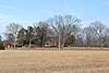
| 23 |
Osage Farms Units No. 5 and No. 6 Historic District |
|
September 27, 1991
(#91001404) |
Range Line Rd. near junction with Trickum Rd.
38°54′35″N 93°16′43″W / 38.909722°N 93.278611°W / 38.909722; -93.278611 (Osage Farms Units No. 5 and No. 6 Historic District) |
Houstonia |
All building have been demolished. |
| 24 |
Osage Farms Units No. 8 and No. 9 Historic District |
|
September 27, 1991
(#91001400) |
MO D near junction with MO T
38°51′48″N 93°21′33″W / 38.863333°N 93.359167°W / 38.863333; -93.359167 (Osage Farms Units No. 8 and No. 9 Historic District) |
Houstonia |
|
| 25 |
Sedalia Commercial Historic District |
|
June 28, 2001
(#01000687) |
Roughly Ohio, Lamine, W. Main, E. Main, and parts of 2nd through 5th Sts.; also 700-712 S. Ohio, 200 S. Moniteau, 101-108 W. Pacific, 104-220 W. Main, 208-400 W. 2nd, 200 W. 4th, and 102-120 E. 5th.
38°42′26″N 93°13′41″W / 38.707222°N 93.228056°W / 38.707222; -93.228056 (Sedalia Commercial Historic District) |
Sedalia |
|
| 26 |
Sedalia Public Library |
|
January 10, 1980
(#80002389) |
311 W. 3rd St.
38°42′30″N 93°13′50″W / 38.708333°N 93.230556°W / 38.708333; -93.230556 (Sedalia Public Library) |
Sedalia |
|
| 27 |
Gen. David Thomson House |
|
October 4, 1982
(#82000588) |
S of Hughesville on SR H
38°46′52″N 93°16′20″W / 38.781111°N 93.272222°W / 38.781111; -93.272222 (Gen. David Thomson House) |
Hughesville |
|