National Register of Historic Places listings in Gasconade County, Missouri
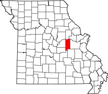
Location of Gasconade County in Missouri
This is a list of the National Register of Historic Places listings in Gasconade County, Missouri.
This is intended to be a complete list of the properties and districts on the National Register of Historic Places in Gasconade County, Missouri, United States. Latitude and longitude coordinates are provided for many National Register properties and districts; these locations may be seen together in a map.[1]
There are 9 properties and districts listed on the National Register in the county.
- This National Park Service list is complete through NPS recent listings posted October 11, 2018.[2]
Current listings
| [3] | Name on the Register | Image | Date listed[4] | Location | City or town | Description |
|---|---|---|---|---|---|---|
| 1 | Hermann Historic District | 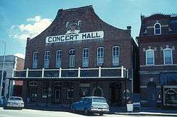 |
February 1, 1972 (#72000712) |
Roughly bounded by E. Wharf, Mozart, E. 5th, and Gellert Sts.; also 214 and 304 Franklin, 301-501 Gellert, and 2202 Route 100; also roughly bounded by Wharf, 1st, Mozart, 5th, Schiller, 4th, Gutenberg, and Reserve Sts. 38°42′19″N 91°26′04″W / 38.705278°N 91.434444°W |
Hermann | Second and third sets of boundaries represent boundary increases of November 29, 2006 and October 30, 2009 respectively |
| 2 | Kotthoff-Weeks Farm Complex | March 28, 1983 (#83000988) |
Off Route J 38°38′04″N 91°31′50″W / 38.634444°N 91.530556°W |
Hermann | ||
| 3 | Old Stone Hill Historic District | 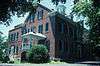 |
May 21, 1969 (#69000102) |
Bounded roughly by W. 12th, Goethe and Jefferson Sts., and Iron Rd. 38°41′48″N 91°26′45″W / 38.696667°N 91.445833°W |
Hermann | See Stone Hill Winery |
| 4 | Peenie Petroglyph Archeological Site | July 29, 1969 (#69000101) |
Address Restricted |
Bem | ||
| 5 | William Poeschel House | June 21, 1990 (#90000982) |
W. 10th St. approximately 2 miles (3.2 km) west of the Hermann city limits 38°41′43″N 91°28′11″W / 38.695278°N 91.469722°W |
Hermann | ||
| 6 | The Rotunda | November 2, 1995 (#95001180) |
City Park, Washington St. 38°41′57″N 91°26′32″W / 38.699167°N 91.442222°W |
Hermann | ||
| 7 | Ruskaup House | March 29, 1983 (#83000989) |
West of Drake on U.S. Route 50 38°29′05″N 91°31′53″W / 38.484722°N 91.531389°W |
Drake | ||
| 8 | Shobe-Morrison House | February 10, 1983 (#83000990) |
West of Morrison off Route 100 38°40′24″N 91°38′16″W / 38.673333°N 91.637778°W |
Morrison | ||
| 9 | Vallet-Danuser House | September 23, 1982 (#82003136) |
East of Hermann on Route 100 38°42′16″N 91°24′54″W / 38.704444°N 91.415°W |
Hermann |
See also
References
| Wikimedia Commons has media related to National Register of Historic Places in Gasconade County, Missouri. |
- ↑ The latitude and longitude information provided in this table was derived originally from the National Register Information System, which has been found to be fairly accurate for about 99% of listings. For about 1% of NRIS original coordinates, experience has shown that one or both coordinates are typos or otherwise extremely far off; some corrections may have been made. A more subtle problem causes many locations to be off by up to 150 yards, depending on location in the country: most NRIS coordinates were derived from tracing out latitude and longitudes from USGS topographical quadrant maps created under the North American Datum of 1927, which differs from the current, highly accurate WGS84 GPS system used by most on-line maps. Chicago is about right, but NRIS longitudes in Washington are higher by about 4.5 seconds, and are lower by about 2.0 seconds in Maine. Latitudes differ by about 1.0 second in Florida. Some locations in this table may have been corrected to current GPS standards.
- ↑ "National Register of Historic Places: Weekly List Actions". National Park Service, United States Department of the Interior. Retrieved on October 11, 2018.
- ↑ Numbers represent an ordering by significant words. Various colorings, defined here, differentiate National Historic Landmarks and historic districts from other NRHP buildings, structures, sites or objects.
- ↑ The eight-digit number below each date is the number assigned to each location in the National Register Information System database, which can be viewed by clicking the number.
| Topics | |
|---|---|
| Lists by states |
|
| Lists by insular areas | |
| Lists by associated states | |
| Other areas | |
| |


Municipalities and communities of Gasconade County, Missouri, United States | ||
|---|---|---|
| Cities | | |
| Townships | ||
| Unincorporated community | ||
| Ghost towns | ||
| Footnotes | ‡This populated place also has portions in an adjacent county or counties | |
This article is issued from
Wikipedia.
The text is licensed under Creative Commons - Attribution - Sharealike.
Additional terms may apply for the media files.