National Register of Historic Places listings in Shannon County, Missouri
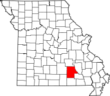
Location of Shannon County in Missouri
This is a list of the National Register of Historic Places listings in Shannon County, Missouri.
This is intended to be a complete list of the properties and districts on the National Register of Historic Places in Shannon County, Missouri, United States. Latitude and longitude coordinates are provided for many National Register properties and districts; these locations may be seen together in a map.[1]
There are 16 properties and districts listed on the National Register in the county.
- This National Park Service list is complete through NPS recent listings posted October 11, 2018.[2]
Current listings
| [3] | Name on the Register | Image | Date listed[4] | Location | City or town | Description |
|---|---|---|---|---|---|---|
| 1 | Akers Ferry Archeological District | 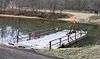 |
October 25, 1990 (#90001541) |
Address restricted |
Rector | |
| 2 | Alley Spring Roller Mill | 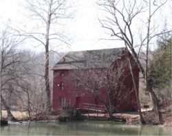 |
December 8, 1981 (#81000336) |
W of Eminence off MO 106 37°09′15″N 91°26′31″W / 37.154167°N 91.441944°W |
Eminence | |
| 3 | Alton Club | 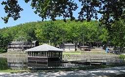 |
October 14, 2005 (#05001162) |
Gravel road, 1.5 mi. W of MO 19 and 12 Mi. N of Eminence 37°19′26″N 91°26′10″W / 37.323889°N 91.436111°W |
Eminence | |
| 4 | Buttin Rock School | May 31, 1991 (#91000605) |
E bank of Current R., S of Powder Mill Ferry, Ozark National Scenic Riverways 37°08′42″N 91°10′12″W / 37.145°N 91.17°W |
Eminence | ||
| 5 | Chilton-Williams Farm Complex | 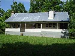 |
September 2, 1981 (#81000696) |
E of Eminence off MO 106 37°11′02″N 91°11′25″W / 37.183889°N 91.190278°W |
Eminence | |
| 6 | Culpepper-Pummil Site (23SH14/55) | February 3, 1988 (#87002500) |
Address restricted |
Alley Spring | ||
| 7 | Walter Klepzig Mill and Farm | 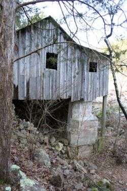 |
February 13, 1990 (#90000001) |
Along Rocky Creek in Ozark National Scenic Riverway 37°07′30″N 91°11′58″W / 37.125°N 91.199444°W |
Eminence | |
| 8 | Old Eminence Site (23SH104) | February 9, 1988 (#87002534) |
Address restricted |
Round Spring | ||
| 9 | Owl's Bend Site (23SH10) | May 12, 1988 (#87002530) |
Address restricted |
Eminence | ||
| 10 | Pulltite Site (23SH94) |  |
February 4, 1988 (#87002532) |
Address restricted |
Eminence | |
| 11 | Reed Log House | 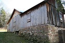 |
April 29, 1991 (#91000456) |
Along Current R. S of Powder Mill Ferry, Ozark National Scenic Riverways 37°09′10″N 91°10′07″W / 37.152778°N 91.168611°W |
Eminence | |
| 12 | Rhinehart Ranch | November 14, 1980 (#80002395) |
NW of Eminence 37°15′03″N 91°26′46″W / 37.250833°N 91.446111°W |
Eminence | ||
| 13 | Round Spring Archeological District | January 25, 1993 (#92001749) |
Vicinity of the spring at Round Spring[5] 37°16′57″N 91°24′28″W / 37.282500°N 91.407778°W |
Eminence | ||
| 14 | Shawnee Creek Site | April 27, 1990 (#90000604) |
Address restricted |
Eminence | ||
| 15 | Two Rivers Site | January 23, 1993 (#92001750) |
Address restricted |
Eminence | ||
| 16 | Winona Ranger Station Historic District | August 4, 2003 (#03000715) |
Rte 1, MO 19N 37°00′49″N 91°19′16″W / 37.013611°N 91.321111°W |
Winona |
See also
References
| Wikimedia Commons has media related to National Register of Historic Places in Shannon County, Missouri. |
- ↑ The latitude and longitude information provided in this table was derived originally from the National Register Information System, which has been found to be fairly accurate for about 99% of listings. For about 1% of NRIS original coordinates, experience has shown that one or both coordinates are typos or otherwise extremely far off; some corrections may have been made. A more subtle problem causes many locations to be off by up to 150 yards, depending on location in the country: most NRIS coordinates were derived from tracing out latitude and longitudes from USGS topographical quadrant maps created under the North American Datum of 1927, which differs from the current, highly accurate WGS84 GPS system used by most on-line maps. Chicago is about right, but NRIS longitudes in Washington are higher by about 4.5 seconds, and are lower by about 2.0 seconds in Maine. Latitudes differ by about 1.0 second in Florida. Some locations in this table may have been corrected to current GPS standards.
- ↑ "National Register of Historic Places: Weekly List Actions". National Park Service, United States Department of the Interior. Retrieved on October 11, 2018.
- ↑ Numbers represent an ordering by significant words. Various colorings, defined here, differentiate National Historic Landmarks and historic districts from other NRHP buildings, structures, sites or objects.
- ↑ The eight-digit number below each date is the number assigned to each location in the National Register Information System database, which can be viewed by clicking the number.
- ↑ Huber, James K., and George Rapp, Jr. "The Palynology of Two Archaeological Sites in the Southeast Missouri Ozarks". Plains Anthropologist 34.126 (1989): 293-308: 295.
| Topics | |
|---|---|
| Lists by states |
|
| Lists by insular areas | |
| Lists by associated states | |
| Other areas | |
| |


Municipalities and communities of Shannon County, Missouri, United States | ||
|---|---|---|
| Cities | | |
| Townships | ||
| CDP | ||
| Unincorporated communities | ||
| Ghost towns | ||
| Footnotes | ‡This populated place also has portions in an adjacent county or counties | |
This article is issued from
Wikipedia.
The text is licensed under Creative Commons - Attribution - Sharealike.
Additional terms may apply for the media files.