Vogüé
| Vogüé | ||
|---|---|---|
| Commune | ||
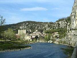 View of Vogüé and the Ardèche River | ||
| ||
 Vogüé Location within Auvergne-Rhône-Alpes region  Vogüé | ||
| Coordinates: 44°33′05″N 4°24′55″E / 44.5514°N 4.4153°ECoordinates: 44°33′05″N 4°24′55″E / 44.5514°N 4.4153°E | ||
| Country | France | |
| Region | Auvergne-Rhône-Alpes | |
| Department | Ardèche | |
| Arrondissement | Largentière | |
| Canton | Vallon-Pont-d'Arc | |
| Government | ||
| • Mayor (2008–2014) | Geneviève Laurent (PR) | |
| Area1 | 11.72 km2 (4.53 sq mi) | |
| Population (2008)2 | 906 | |
| • Density | 77/km2 (200/sq mi) | |
| Time zone | UTC+1 (CET) | |
| • Summer (DST) | UTC+2 (CEST) | |
| INSEE/Postal code | 07348 /07200 | |
| Elevation |
140–342 m (459–1,122 ft) (avg. 148 m or 486 ft) | |
|
1 French Land Register data, which excludes lakes, ponds, glaciers > 1 km2 (0.386 sq mi or 247 acres) and river estuaries. 2 Population without double counting: residents of multiple communes (e.g., students and military personnel) only counted once. | ||
Vogüé is a commune in the Ardèche department in southern France.
Geography
Vogüé is located along the banks of the Ardèche River.
Population
| Historical population | ||
|---|---|---|
| Year | Pop. | ±% |
| 1962 | 549 | — |
| 1968 | 576 | +4.9% |
| 1975 | 546 | −5.2% |
| 1982 | 570 | +4.4% |
| 1990 | 631 | +10.7% |
| 1999 | 726 | +15.1% |
| 2008 | 906 | +24.8% |
See also
References
| Wikimedia Commons has media related to Vogüé. |
This article is issued from
Wikipedia.
The text is licensed under Creative Commons - Attribution - Sharealike.
Additional terms may apply for the media files.