Satillieu
| Satillieu | ||
|---|---|---|
| Commune | ||
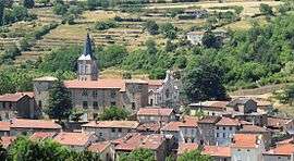 Satillieu seen from the south | ||
| ||
 Satillieu Location within Auvergne-Rhône-Alpes region  Satillieu | ||
| Coordinates: 45°09′05″N 4°36′53″E / 45.1514°N 4.6147°ECoordinates: 45°09′05″N 4°36′53″E / 45.1514°N 4.6147°E | ||
| Country | France | |
| Region | Auvergne-Rhône-Alpes | |
| Department | Ardèche | |
| Arrondissement | Tournon-sur-Rhône | |
| Canton | Haut-Vivarais | |
| Intercommunality | Val d'Ay | |
| Government | ||
| • Mayor (2008–2014) | Pierre Giraud | |
| Area1 | 32.82 km2 (12.67 sq mi) | |
| Population (2008)2 | 1,611 | |
| • Density | 49/km2 (130/sq mi) | |
| Time zone | UTC+1 (CET) | |
| • Summer (DST) | UTC+2 (CEST) | |
| INSEE/Postal code | 07309 /07290 | |
| Elevation |
433–1,225 m (1,421–4,019 ft) (avg. 476 m or 1,562 ft) | |
|
1 French Land Register data, which excludes lakes, ponds, glaciers > 1 km2 (0.386 sq mi or 247 acres) and river estuaries. 2 Population without double counting: residents of multiple communes (e.g., students and military personnel) only counted once. | ||
.svg.png)
Satillieu is a commune in the Ardèche department in southern France. The small commune has a private and public elementary school.
Population
| Historical population | ||
|---|---|---|
| Year | Pop. | ±% |
| 1962 | 1,925 | — |
| 1968 | 1,998 | +3.8% |
| 1975 | 1,972 | −1.3% |
| 1982 | 1,854 | −6.0% |
| 1990 | 1,818 | −1.9% |
| 1999 | 1,592 | −12.4% |
| 2008 | 1,611 | +1.2% |
See also
References
| Wikimedia Commons has media related to Satillieu. |
This article is issued from
Wikipedia.
The text is licensed under Creative Commons - Attribution - Sharealike.
Additional terms may apply for the media files.