Laurac-en-Vivarais
| Laurac-en-Vivarais | ||
|---|---|---|
| Commune | ||
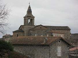 The church in Laurac-en-Vivarais | ||
| ||
 Laurac-en-Vivarais Location within Auvergne-Rhône-Alpes region  Laurac-en-Vivarais | ||
| Coordinates: 44°30′34″N 4°17′27″E / 44.5094°N 4.2908°ECoordinates: 44°30′34″N 4°17′27″E / 44.5094°N 4.2908°E | ||
| Country | France | |
| Region | Auvergne-Rhône-Alpes | |
| Department | Ardèche | |
| Arrondissement | Largentière | |
| Canton | Vallon-Pont-d'Arc | |
| Government | ||
| • Mayor (2008–2014) | Didier Nury | |
| Area1 | 8.97 km2 (3.46 sq mi) | |
| Population (2008)2 | 887 | |
| • Density | 99/km2 (260/sq mi) | |
| Time zone | UTC+1 (CET) | |
| • Summer (DST) | UTC+2 (CEST) | |
| INSEE/Postal code | 07134 /07110 | |
| Elevation |
149–373 m (489–1,224 ft) (avg. 192 m or 630 ft) | |
|
1 French Land Register data, which excludes lakes, ponds, glaciers > 1 km2 (0.386 sq mi or 247 acres) and river estuaries. 2 Population without double counting: residents of multiple communes (e.g., students and military personnel) only counted once. | ||
.svg.png)
Laurac-en-Vivarais is a commune in the Ardèche department in southern France.
Population
| Historical population | ||
|---|---|---|
| Year | Pop. | ±% |
| 1962 | 660 | — |
| 1968 | 802 | +21.5% |
| 1975 | 763 | −4.9% |
| 1982 | 797 | +4.5% |
| 1990 | 789 | −1.0% |
| 1999 | 784 | −0.6% |
| 2008 | 887 | +13.1% |
See also
References
| Wikimedia Commons has media related to Laurac-en-Vivarais. |
This article is issued from
Wikipedia.
The text is licensed under Creative Commons - Attribution - Sharealike.
Additional terms may apply for the media files.