Sablières
| Sablières | |
|---|---|
| Commune | |
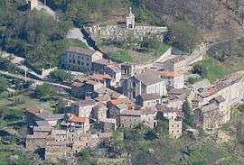 An aerial view of Sablières | |
 Sablières Location within Auvergne-Rhône-Alpes region  Sablières | |
| Coordinates: 44°31′58″N 4°04′31″E / 44.5328°N 4.0753°ECoordinates: 44°31′58″N 4°04′31″E / 44.5328°N 4.0753°E | |
| Country | France |
| Region | Auvergne-Rhône-Alpes |
| Department | Ardèche |
| Arrondissement | Largentière |
| Canton | Les Cévennes ardéchoises |
| Intercommunality | Cévennes et Vivaroises |
| Government | |
| • Mayor (2008–2014) | Michel Talagrand |
| Area1 | 38.98 km2 (15.05 sq mi) |
| Population (2008)2 | 145 |
| • Density | 3.7/km2 (9.6/sq mi) |
| Time zone | UTC+1 (CET) |
| • Summer (DST) | UTC+2 (CEST) |
| INSEE/Postal code | 07202 /07260 |
| Elevation |
314–1,261 m (1,030–4,137 ft) (avg. 475 m or 1,558 ft) |
|
1 French Land Register data, which excludes lakes, ponds, glaciers > 1 km2 (0.386 sq mi or 247 acres) and river estuaries. 2 Population without double counting: residents of multiple communes (e.g., students and military personnel) only counted once. | |
Sablières is a commune in the Ardèche department in southern France.
Population
| Historical population | ||
|---|---|---|
| Year | Pop. | ±% |
| 1962 | 240 | — |
| 1968 | 200 | −16.7% |
| 1975 | 142 | −29.0% |
| 1982 | 130 | −8.5% |
| 1990 | 149 | +14.6% |
| 1999 | 101 | −32.2% |
| 2008 | 145 | +43.6% |
See also
References
| Wikimedia Commons has media related to Sablières. |
This article is issued from
Wikipedia.
The text is licensed under Creative Commons - Attribution - Sharealike.
Additional terms may apply for the media files.