Rochemaure
| Rochemaure | ||
|---|---|---|
| Commune | ||
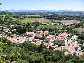 A general view of Rochemaure | ||
| ||
 Rochemaure Location within Auvergne-Rhône-Alpes region  Rochemaure | ||
| Coordinates: 44°35′18″N 4°42′14″E / 44.5883°N 4.704°ECoordinates: 44°35′18″N 4°42′14″E / 44.5883°N 4.704°E | ||
| Country | France | |
| Region | Auvergne-Rhône-Alpes | |
| Department | Ardèche | |
| Arrondissement | Privas | |
| Canton | Le Pouzin | |
| Intercommunality | Barrès-Coiron | |
| Government | ||
| • Mayor (2008–2014) | Christian Lecerf | |
| Area1 | 24.33 km2 (9.39 sq mi) | |
| Population (2008)2 | 1,991 | |
| • Density | 82/km2 (210/sq mi) | |
| Time zone | UTC+1 (CET) | |
| • Summer (DST) | UTC+2 (CEST) | |
| INSEE/Postal code | 07191 /07400 | |
| Elevation |
55–682 m (180–2,238 ft) (avg. 76 m or 249 ft) | |
|
1 French Land Register data, which excludes lakes, ponds, glaciers > 1 km2 (0.386 sq mi or 247 acres) and river estuaries. 2 Population without double counting: residents of multiple communes (e.g., students and military personnel) only counted once. | ||

Rochemaure is a commune in the Ardèche department in southern France. Many inhabitants of Rochemaure are in favour of the proposed road deviation in order to preserve the historic and cultural nature of the village. It is classified as a "village of character" however currently has a major departmental road running through it. The deviation would improve safety for cyclists of the Viarhonna as well as children who attend the local schools.
Population
| Historical population | ||
|---|---|---|
| Year | Pop. | ±% |
| 1962 | 787 | — |
| 1968 | 970 | +23.3% |
| 1975 | 1,067 | +10.0% |
| 1982 | 1,789 | +67.7% |
| 1990 | 1,809 | +1.1% |
| 1999 | 1,870 | +3.4% |
| 2008 | 1,991 | +6.5% |
See also
References
| Wikimedia Commons has media related to Rochemaure. |
This article is issued from
Wikipedia.
The text is licensed under Creative Commons - Attribution - Sharealike.
Additional terms may apply for the media files.