Savas
| Savas | |
|---|---|
| Commune | |
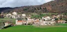 A view of the village, including the church, town hall and private school | |
 Savas Location within Auvergne-Rhône-Alpes region  Savas | |
| Coordinates: 45°17′51″N 4°41′34″E / 45.2975°N 4.6928°ECoordinates: 45°17′51″N 4°41′34″E / 45.2975°N 4.6928°E | |
| Country | France |
| Region | Auvergne-Rhône-Alpes |
| Department | Ardèche |
| Arrondissement | Tournon-sur-Rhône |
| Canton | Annonay-1 |
| Intercommunality | Bassin d'Annonay |
| Government | |
| • Mayor (2008–2014) | Alain Thomas |
| Area1 | 12.44 km2 (4.80 sq mi) |
| Population (2008)2 | 802 |
| • Density | 64/km2 (170/sq mi) |
| Time zone | UTC+1 (CET) |
| • Summer (DST) | UTC+2 (CEST) |
| INSEE/Postal code | 07310 /07430 |
| Elevation |
448–738 m (1,470–2,421 ft) (avg. 550 m or 1,800 ft) |
|
1 French Land Register data, which excludes lakes, ponds, glaciers > 1 km2 (0.386 sq mi or 247 acres) and river estuaries. 2 Population without double counting: residents of multiple communes (e.g., students and military personnel) only counted once. | |
Savas is a commune in the Ardèche department in southern France.
Population
| Historical population | ||
|---|---|---|
| Year | Pop. | ±% |
| 1962 | 281 | — |
| 1968 | 282 | +0.4% |
| 1975 | 310 | +9.9% |
| 1982 | 508 | +63.9% |
| 1990 | 575 | +13.2% |
| 1999 | 694 | +20.7% |
| 2008 | 802 | +15.6% |
See also
References
| Wikimedia Commons has media related to Savas. |
This article is issued from
Wikipedia.
The text is licensed under Creative Commons - Attribution - Sharealike.
Additional terms may apply for the media files.