Borne, Ardèche
| Borne | ||
|---|---|---|
| Commune | ||
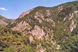 The Tour de Borne | ||
| ||
 Borne Location within Auvergne-Rhône-Alpes region  Borne | ||
| Coordinates: 44°36′56″N 4°00′58″E / 44.6156°N 4.0161°ECoordinates: 44°36′56″N 4°00′58″E / 44.6156°N 4.0161°E | ||
| Country | France | |
| Region | Auvergne-Rhône-Alpes | |
| Department | Ardèche | |
| Arrondissement | Largentière | |
| Canton | Haute-Ardèche | |
| Intercommunality | Cévenne et Montagne Ardéchoise | |
| Government | ||
| • Mayor (2008–2014) | Thierry Champel | |
| Area1 | 32.01 km2 (12.36 sq mi) | |
| Population (2008)2 | 41 | |
| • Density | 1.3/km2 (3.3/sq mi) | |
| Time zone | UTC+1 (CET) | |
| • Summer (DST) | UTC+2 (CEST) | |
| INSEE/Postal code | 07038 /07590 | |
| Elevation |
750–1,506 m (2,461–4,941 ft) (avg. 6,001 m or 19,688 ft) | |
|
1 French Land Register data, which excludes lakes, ponds, glaciers > 1 km2 (0.386 sq mi or 247 acres) and river estuaries. 2 Population without double counting: residents of multiple communes (e.g., students and military personnel) only counted once. | ||

Borne is a commune in the Ardèche department in southern France.
Population
| Historical population | ||
|---|---|---|
| Year | Pop. | ±% |
| 1962 | 89 | — |
| 1968 | 66 | −25.8% |
| 1975 | 39 | −40.9% |
| 1982 | 31 | −20.5% |
| 1990 | 42 | +35.5% |
| 1999 | 41 | −2.4% |
| 2008 | 41 | +0.0% |
See also
References
| Wikimedia Commons has media related to Borne, Ardèche. |
This article is issued from
Wikipedia.
The text is licensed under Creative Commons - Attribution - Sharealike.
Additional terms may apply for the media files.