Péreyres
| Péreyres | |
|---|---|
| Commune | |
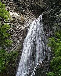 Ray Pic waterfall | |
 Péreyres Location within Auvergne-Rhône-Alpes region  Péreyres | |
| Coordinates: 44°46′40″N 4°15′16″E / 44.7778°N 4.2544°ECoordinates: 44°46′40″N 4°15′16″E / 44.7778°N 4.2544°E | |
| Country | France |
| Region | Auvergne-Rhône-Alpes |
| Department | Ardèche |
| Arrondissement | Largentière |
| Canton | Haute-Ardèche |
| Government | |
| • Mayor (2008–2014) | Yves Bonnet |
| Area1 | 12.63 km2 (4.88 sq mi) |
| Population (2008)2 | 53 |
| • Density | 4.2/km2 (11/sq mi) |
| Time zone | UTC+1 (CET) |
| • Summer (DST) | UTC+2 (CEST) |
| INSEE/Postal code | 07173 /07450 |
| Elevation |
676–1,400 m (2,218–4,593 ft) (avg. 750 m or 2,460 ft) |
|
1 French Land Register data, which excludes lakes, ponds, glaciers > 1 km2 (0.386 sq mi or 247 acres) and river estuaries. 2 Population without double counting: residents of multiple communes (e.g., students and military personnel) only counted once. | |
Péreyres is a commune in the Ardèche department in the Auvergne-Rhône-Alpes region in southern France.
Population
| Historical population | ||
|---|---|---|
| Year | Pop. | ±% |
| 1962 | 48 | — |
| 1968 | 75 | +56.2% |
| 1975 | 63 | −16.0% |
| 1982 | 62 | −1.6% |
| 1990 | 62 | +0.0% |
| 1999 | 55 | −11.3% |
| 2008 | 53 | −3.6% |
See also
References
| Wikimedia Commons has media related to Péreyres. |
This article is issued from
Wikipedia.
The text is licensed under Creative Commons - Attribution - Sharealike.
Additional terms may apply for the media files.