Saint-Vincent-de-Durfort
| Saint-Vincent-de-Durfort | |
|---|---|
| Commune | |
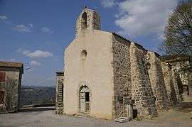 The church in Saint-Vincent-de-Durfort | |
 Saint-Vincent-de-Durfort Location within Auvergne-Rhône-Alpes region  Saint-Vincent-de-Durfort | |
| Coordinates: 44°48′22″N 4°38′41″E / 44.8061°N 4.6447°ECoordinates: 44°48′22″N 4°38′41″E / 44.8061°N 4.6447°E | |
| Country | France |
| Region | Auvergne-Rhône-Alpes |
| Department | Ardèche |
| Arrondissement | Privas |
| Canton | Haut-Eyrieux |
| Intercommunality | Eyrieux aux Serres |
| Government | |
| • Mayor (2008–2014) | Roland Roucaute |
| Area1 | 12.52 km2 (4.83 sq mi) |
| Population (2008)2 | 222 |
| • Density | 18/km2 (46/sq mi) |
| Time zone | UTC+1 (CET) |
| • Summer (DST) | UTC+2 (CEST) |
| INSEE/Postal code | 07303 /07360 |
| Elevation |
153–829 m (502–2,720 ft) (avg. 320 m or 1,050 ft) |
|
1 French Land Register data, which excludes lakes, ponds, glaciers > 1 km2 (0.386 sq mi or 247 acres) and river estuaries. 2 Population without double counting: residents of multiple communes (e.g., students and military personnel) only counted once. | |
Saint-Vincent-de-Durfort is a commune in the Ardèche department in southern France.
Population
| Historical population | ||
|---|---|---|
| Year | Pop. | ±% |
| 1962 | 148 | — |
| 1968 | 189 | +27.7% |
| 1975 | 159 | −15.9% |
| 1982 | 141 | −11.3% |
| 1990 | 163 | +15.6% |
| 1999 | 213 | +30.7% |
| 2008 | 222 | +4.2% |
See also
References
| Wikimedia Commons has media related to Saint-Vincent-de-Durfort. |
This article is issued from
Wikipedia.
The text is licensed under Creative Commons - Attribution - Sharealike.
Additional terms may apply for the media files.