Urana
| Urana New South Wales | |||||||||
|---|---|---|---|---|---|---|---|---|---|
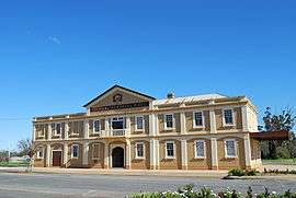 Memorial Hall, Urana | |||||||||
|
Urana | |||||||||
| Coordinates | 35°19′0″S 146°16′0″E / 35.31667°S 146.26667°ECoordinates: 35°19′0″S 146°16′0″E / 35.31667°S 146.26667°E | ||||||||
| Population | 384 (2016 census)[1] | ||||||||
| Established | 6 May 1859[2] | ||||||||
| Postcode(s) | 2645 | ||||||||
| Elevation | 125.0 m (410 ft) | ||||||||
| Location |
| ||||||||
| LGA(s) | Federation Council | ||||||||
| County | Urana | ||||||||
| State electorate(s) | Albury | ||||||||
| Federal Division(s) | Farrer | ||||||||
| |||||||||
Urana /jəˈrænə/ is a small town in the Riverina region of New South Wales, Australia. The town is in the Federation Council local government area.
Urana is located between Lockhart and Jerilderie, about 561 kilometres (349 mi) southwest of the state capital, Sydney. To the west lies Lake Urana and the Lake Urana Nature Reserve. To the east lies a smaller lake, Lake Uranagong.
Urana was the major town and headquarters of the former Urana Shire. The shire included the localities of Boree Creek, Morundah, Oaklands and Rand. The Urana district is used for raising sheep and for growing wheat and other grain crops.
In the 2016 census, there were 384 people in Urana (State Suburb), which includes surrounding grazing land, of these 54.5% were male and 45.5% were female. Aboriginal and Torres Strait Islander people made up 4.1% of the population.[1]
History
Urana was first settled by Europeans during the 1850s. In May 1859 a design for the "Town of Urana" by Surveyor Hayes was approved by the New South Wales Executive Council. The name Urana comes from the Aboriginal word 'airana', meaning a temporary shelter (usually consisting of a simple frame of branches covered with bark, leaves, or grass).[3]
Urana Post Office opened on 1 January 1861.[4]
In August 1863 near Urana the notorious bushranger, Dan 'Mad Dog' Morgan, and his accomplice Clarke held up the Police Magistrate based at Wagga Wagga, Henry Baylis. A few days after this incident Baylis led a party of policemen to the bushrangers' camp; shots were exchanged and both Baylis and the bushranger Clarke were wounded. Morgan and Clarke both escaped on this occasion.[5]
In 1866 Urana township consisted of two public houses, the Urana Hotel and the Royal Hotel. In addition there was a post-office, two large stores, and a police-station and lock-up. A new court-house was erected at Urana in 1879. During 1882 a Roman Catholic church was completed, with Father Burmingham celebrating the first service on 7 January 1883.[3]
The Rev. George Wilson Adam was the first Presbyterian minister of the separate parish of Urana (at that time administered from Victoria). Rev. Adams’ term extended from 1878 to 1887. His successor, Rev. Matthew Bell, was a part of the Presbyterian Church of New South Wales; he was inducted in 1888 and resigned in 1904. During Rev. Bell’s tenure at Urana three wooden churches were built: one at Urana, and one each at the district preaching centres, Old Goree and Boree Creek.[6]
Urana Shire Council was proclaimed in 1906 and dissolved in 2016, to become part of the Federation Council.
Heritage listings
Urana has a number of heritage-listed sites, including:
- Anna Street: Urana Soldiers' Memorial Hall[7]
Climate
| Climate data for Urana | |||||||||||||
|---|---|---|---|---|---|---|---|---|---|---|---|---|---|
| Month | Jan | Feb | Mar | Apr | May | Jun | Jul | Aug | Sep | Oct | Nov | Dec | Year |
| Average high °C (°F) | 32.9 (91.2) |
32.4 (90.3) |
29.2 (84.6) |
23.6 (74.5) |
18.7 (65.7) |
14.8 (58.6) |
14.2 (57.6) |
16.0 (60.8) |
19.8 (67.6) |
23.5 (74.3) |
27.7 (81.9) |
31.1 (88) |
23.7 (74.7) |
| Average low °C (°F) | 16.3 (61.3) |
16.3 (61.3) |
14.0 (57.2) |
9.4 (48.9) |
6.1 (43) |
3.6 (38.5) |
3.2 (37.8) |
4.1 (39.4) |
6.3 (43.3) |
8.8 (47.8) |
11.8 (53.2) |
14.6 (58.3) |
9.5 (49.1) |
| Average precipitation mm (inches) | 31.8 (1.252) |
34.1 (1.343) |
34.6 (1.362) |
32.1 (1.264) |
41.3 (1.626) |
44.8 (1.764) |
39.1 (1.539) |
39.9 (1.571) |
38.2 (1.504) |
41.2 (1.622) |
32.4 (1.276) |
32.4 (1.276) |
442.0 (17.402) |
| Source: [8] | |||||||||||||
Notable residents
Notable people from Urana include:
- Rugby league player Norm Provan
- Singer Billy Field
- AFL Football Player Billy Brownless was born at the Urana Hospital
Gallery
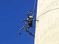 Sculpture 'Itsy Bitsy' by local artist Andrew Whitehead on the water tower.
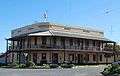 Hotel Urana, the only remaining pub in Urana.
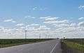 The flat Urana plain
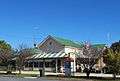 Historic post office
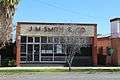 JM Smith office
External links
![]()
| Preceding station | NSW Branch lines | Following station | ||
|---|---|---|---|---|
towards Oaklands | Oaklands Line (closed section) | towards The Rock |
References
- 1 2 Australian Bureau of Statistics (31 October 2012). "Urana (State Suburb)". 2011 Census QuickStats.

- ↑ "Urana decked out for its 150th". The Weekend Advertiser. 2009-05-09. p. 4.
- 1 2 Jervis, James (1952). "The Western Riverina: A History of Its Development". Royal Australian Historical Society Journal and Proceedings. Vol. XXXVIII: 242–3.
- ↑ Premier Postal History. "Post Office List". Archived from the original on 19 August 2008. Retrieved 11 June 2009.
- ↑ ‘Baylis, Henry (1826 - 1905)’, Australian Dictionary of Biography (online edition)
- ↑ Cameron, Rev. James, M.A., D.D. (1905). Centenary History of the Presbyterian Church in New South Wales (Urana details). Sydney: Angus & Robertson. pp. 297–306.
- ↑ "Urana Soldiers' Memorial Hall, New South Wales State Heritage Register (NSW SHR) Number H01966". New South Wales State Heritage Register. Office of Environment and Heritage. Retrieved 18 May 2018.
- ↑ "Climate statistics for". Bureau of Meteorology. Retrieved 21 January 2014.