U.S. Route 400
| ||||||||||||
|---|---|---|---|---|---|---|---|---|---|---|---|---|
 | ||||||||||||
| Route information | ||||||||||||
| Length | 481.306 mi[lower-alpha 1] (774.587 km) | |||||||||||
| Existed | 1994–present | |||||||||||
| History | Extended west in 1996 | |||||||||||
| Major junctions | ||||||||||||
| West end |
| |||||||||||
| ||||||||||||
| East end |
| |||||||||||
| Location | ||||||||||||
| States | Colorado, Kansas, Missouri | |||||||||||
| Highway system | ||||||||||||
|
Colorado State Highways
| ||||||||||||

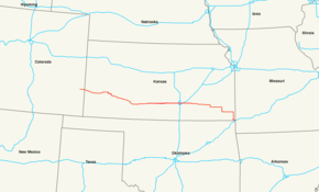
U.S. Route 400 (US 400) is a 481.306-mile-long (774.587 km) mostly east–west U.S. Highway, commissioned in 1994. The highway's western terminus is in Granada, Colorado, at an intersection with US 385. The highway's eastern terminus is southwest of Joplin, Missouri, near Loma Linda, at an interchange with Interstate 44, with which it shares with US 166. It originally ended in Garden City, Kansas; in 1996 it was extended to its current western terminus.
Route description
Colorado
US 400 begins in Granada at an intersection with US 385. It then runs concurrently with US 50 through Holly east to the Kansas border.
Kansas
US-400 and US-50 enter Kansas west of Coolidge. They run concurrently through Garden City, where it intersects US-83 and separate at Dodge City, which is where it intersects US-56 and US-283. It continues southeast from Dodge City and first intersects US-54 at Mullinville.
US-400 and US-54 begin a long concurrency at Mullinville which passes through Greensburg, Pratt, and Kingman before entering Wichita. While in Wichita, US-400 and US-54 intersect Interstate 235 and the concurrency of US-81 and Interstate 135. K-96 provides a short freeway connection to Interstate 35, which is also the Kansas Turnpike. At Augusta, US-400 and US-54 enter into another concurrency with US-77, and US-400 breaks from this concurrency at Haverhill.

US-400 continues east through several small towns before turning southeast to go through the Fredonia area and intersecting US-75 at Neodesha. After a brief concurrency with US-75, it turns east, intersecting US-59 near Parsons before intersecting US-69 south of Pittsburg. It then turns south with US-69 and at Crestline, follows US-69A south to Riverton. US-400 then turns east with US-166 at Baxter Springs, and the two highways run concurrently eastward into Missouri.
Missouri
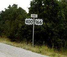
US 400, along with US 166, terminates at I-44 about one mile (1.6 km) east of the Kansas-Missouri state line, three miles (5 km) west of Joplin.
History
U.S. Route 154
A section of U.S. 400 that ran from Dodge City to Mullinville, Kansas was U.S. Route 154 from 1926 to 1982. It later became K-154 before becoming part of U.S. 400.
Major intersections
| State | County | Location | mi[lower-alpha 2] | km | Destinations | Notes |
|---|---|---|---|---|---|---|
| Colorado | Prowers | Granada | 0.000 | 0.000 | Western end of US 50 overlap | |
| | 5.719 | 9.204 | Road 30 – Hartman | Former SH 196 | ||
| Holly | 10.737 | 17.280 | ||||
| 14.814 0.000 | 23.841 0.000 | Colorado–Kansas state line | ||||
| Kansas | Hamilton | Syracuse | 16.094 | 25.901 | Western end of concurrency with K-27 | |
| 16.624 | 26.754 | Eastern end of concurrency with K-27 | ||||
| Kearny | Lakin | 43.965 | 70.755 | |||
| Finney | Holcomb | 59.848 | 96.316 | Big Lowe Road – Holcomb | Diamond interchange | |
| Garden City | 65.848 | 105.972 | Diamond interchange; western end of concurrency with US-83 | |||
| 69.618 | 112.039 | Pair of half-diamond interchanges with one-way ramps connecting Mary Street and K-156 | ||||
| 71.156 | 114.514 | Partial cloverleaf interchange; eastern end of concurrency with US-83 | ||||
| Gray | Cimarron | 102.427 | 164.840 | |||
| Ford | | 116.681 | 187.780 | Eastern end of US-50 overlap | ||
| | 119.852 | 192.883 | Western end of US-56 overlap | |||
| | 123.395 | 198.585 | Western end of US-283 overlap | |||
| Dodge City | 126.825 | 204.105 | Eastern end of US-56 / US-283 overlap | |||
| | 147.625 | 237.579 | ||||
| Kiowa | | 160.797 | 258.778 | Interchange; western end of US-54 overlap; westbound exit and eastbound entrance | ||
| | 167.767 | 269.995 | ||||
| Pratt | Pratt | 199.963 | 321.809 | |||
| 201.236 | 323.858 | |||||
| | 202.346 | 325.644 | Southeast 25th Avenue – Pratt County Lake | Formerly K-64 | ||
| Kingman | | 217.105 | 349.397 | 170th Avenue – Cunningham | Interchange | |
| | 230.329 | 370.679 | ||||
| Kingman | 234.554 | 377.478 | Western end of K-14 overlap | |||
| | 238.301 | 383.508 | 40th Avenue | Interchange; western end of freeway | ||
| | 239.009 | 384.648 | 70th Avenue | |||
| | 244.713 | 393.827 | Eastern end of K-14 overlap | |||
| | 249.778 | 401.979 | Mount Vernon (150th Avenue) | |||
| Sedgwick | | 252.769 | 406.792 | |||
| | 253.769 | 408.402 | 383rd West – Cheney | |||
| | 255.819 | 411.701 | 343rd West – St. Joe | |||
| | 258.820 | 416.530 | 295th West – Garden Plain | Interchange; eastern end of freeway; former K-163 | ||
| Wichita | 270.840 | 435.875 | Maize Road | Interchange; western end of freeway | ||
| 271.840 | 437.484 | Tyler Road | ||||
| 272.829 | 439.076 | Ridge Road – Mid-Continent Airport | ||||
| 273.838 | 440.700 | Dugan Road | No direct eastbound exit (signed at Ridge Road) | |||
| 274.303 | 441.448 | I-235 exit 7 | ||||
| 274.840 | 442.312 | West Street | ||||
| Edwards / Meridian | former K-42 | |||||
| Seneca / Sycamore | ||||||
| 253.789 | 408.434 | Central Business District | ||||
| 278.459 | 448.136 | Washington Avenue | ||||
| 279.205 | 449.337 | I-135 exits 5B-6A | ||||
| Grove Street | Westbound exit and eastbound entrance | |||||
| Hillside | ||||||
| Oliver / Edgemoor | ||||||
| Woodlawn | no direct westbound exit (signed at Armour) | |||||
| Towne East Drive / Armour | ||||||
| 285.943 | 460.181 | Rock | Interchange; no direct eastbound exit (signed at Armour) | |||
| Kansas Turnpike exit 50 | ||||||
| 286.017 | 460.300 | Webb | Under construction | |||
| Greenwich | Under construction | |||||
| Zelta Road 127th Street | Under construction; Eastern end of freeway | |||||
| | 286.172 | 460.549 | Interchange | |||
| Butler | Augusta | 297.431 | 478.669 | Western end of US-77 overlap | ||
| | 302.952 | 487.554 | Haverhill, Smileyberg | Interchange | ||
| | 305.143 | 491.080 | Interchange; eastern end of US-54 / US-77 overlap | |||
| Greenwood | | 338.268 | 544.390 | Western end of K-99 overlap | ||
| | 339.315 | 546.075 | Eastern end of K-99 overlap | |||
| Wilson | | 358.104 | 576.313 | |||
| | 366.496 | 589.818 | Roundabout | |||
| | 377.295 | 607.197 | Interchange; western end of US-75 overlap | |||
| Montgomery | | 381.326 | 613.685 | Interchange; eastern end of US-75 overlap | ||
| | 390.527 | 628.492 | Interchange | |||
| Labette | | 397.052 | 638.993 | Dennis via county road, Mound Valley via county road, Big Hill Lake | Former K-133 | |
| Parsons | 406.061 | 653.492 | Interchange | |||
| Cherokee–Crawford county line | | 420.172 | 676.201 | |||
| Cherokee | 430.148 | 692.256 | ||||
| | 437.128 | 703.489 | Western end of US-69 / US-160 overlap | |||
| Cherokee | | 439.095 | 706.655 | |||
| | 448.223 | 721.345 | Eastern end of US-69 / US-160 overlap; western end of US-69 Alt. overlap | |||
| | 455.507 | 733.067 | Roundabout | |||
| | 457.274 | 735.911 | Eastern end of US-69 Alt. overlap | |||
| | 460.350 | 740.862 | Western end of US-166 overlap | |||
| | 462.251 | 743.921 | ||||
| 465.556 0.000 | 749.240 0.000 | Kansas–Missouri state line | ||||
| Missouri | Newton | | 0.936 | 1.506 | I-44 exit 1; eastern end of US 166 overlap | |
1.000 mi = 1.609 km; 1.000 km = 0.621 mi
| ||||||
See also
Notes
References
- 1 2 "OTIS Highway Data Explorer". Colorado Department of Transportation. Archived from the original on September 10, 2012. Retrieved April 15, 2017.
- 1 2 Staff (2016). "Pavement Management Information System". Kansas Department of Transportation. Retrieved April 16, 2017.
- 1 2 Missouri Department of Transportation (April 16, 2017). MoDOT HPMAPS (Map). Missouri Department of Transportation. Retrieved April 16, 2017.
External links
- Kansas Highway Maps: Current, Historic, KDOT
- Sanderson, Dale End of U.S. Highway 400 (with maps of US 400 and related routes)
Routes in italics are no longer a part of the system. Highlighted routes are considered main routes of the system. |