Garden Plain, Kansas
| Garden Plain, Kansas | |
|---|---|
| City | |
 Location within Sedgwick County and Kansas | |
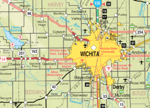 KDOT map of Sedgwick County (legend) | |
| Coordinates: 37°39′38″N 97°40′55″W / 37.66056°N 97.68194°WCoordinates: 37°39′38″N 97°40′55″W / 37.66056°N 97.68194°W | |
| Country | United States |
| State | Kansas |
| County | Sedgwick |
| Area[1] | |
| • Total | 0.60 sq mi (1.55 km2) |
| • Land | 0.60 sq mi (1.55 km2) |
| • Water | 0 sq mi (0 km2) |
| Elevation | 1,453 ft (443 m) |
| Population (2010)[2] | |
| • Total | 773 |
| • Estimate (2016)[3] | 894 |
| • Density | 1,300/sq mi (500/km2) |
| Time zone | UTC-6 (Central (CST)) |
| • Summer (DST) | UTC-5 (CDT) |
| ZIP code | 67050 |
| Area code | 316 |
| FIPS code | 20-25375 [4] |
| GNIS feature ID | 0473990 [5] |
| Website | GardenPlain.com |
Garden Plain is a city in Sedgwick County, Kansas, United States. As of the 2010 census, the city population was 773.[6]
History
Garden Plain had its start by the building of the Wichita and Western Railroad from Wichita to Kingman.[7] Garden Plain was incorporated in 1902.[8]
Geography
Garden Plain is located at 37°39′38″N 97°40′55″W / 37.66056°N 97.68194°W (37.660451, -97.681811).[9] According to the United States Census Bureau, the city has a total area of 0.60 square miles (1.55 km2), all of it land.[1]
Demographics
| Historical population | |||
|---|---|---|---|
| Census | Pop. | %± | |
| 1910 | 296 | — | |
| 1920 | 361 | 22.0% | |
| 1930 | 336 | −6.9% | |
| 1940 | 323 | −3.9% | |
| 1950 | 323 | 0.0% | |
| 1960 | 560 | 73.4% | |
| 1970 | 678 | 21.1% | |
| 1980 | 775 | 14.3% | |
| 1990 | 731 | −5.7% | |
| 2000 | 797 | 9.0% | |
| 2010 | 773 | −3.0% | |
| U.S. Decennial Census | |||
2015 census
As of the census[10] of 2015, there were 879 people. The racial makeup of the city was 97.6% White, 0.1% African American, 0.3% Native American, 0.0% Asian, 0.2% from other races, and 0.0% from two or more races. Hispanic or Latino of any race were 1.7% of the population.
2010 census
As of the census[2] of 2010, there were 849 people, 308 households, and 221 families residing in the city. The population density was 1,415.0 inhabitants per square mile (546.3/km2). There were 320 housing units at an average density of 533.3 per square mile (205.9/km2). The racial makeup of the city was 97.8% White, 0.4% African American, 0.2% Native American, 0.1% Asian, 0.2% from other races, and 1.3% from two or more races. Hispanic or Latino of any race were 0.6% of the population.
There were 308 households of which 43.2% had children under the age of 18 living with them, 58.4% were married couples living together, 8.8% had a female householder with no husband present, 4.5% had a male householder with no wife present, and 28.2% were non-families. 26.9% of all households were made up of individuals and 15.3% had someone living alone who was 65 years of age or older. The average household size was 2.76 and the average family size was 3.40.
The median age in the city was 34.5 years. 33.1% of residents were under the age of 18; 6.8% were between the ages of 18 and 24; 24.9% were from 25 to 44; 22.5% were from 45 to 64; and 12.7% were 65 years of age or older. The gender makeup of the city was 49.7% male and 50.3% female.
2000 census
As of the census[4] of 2000, there were 797 people, 286 households, and 201 families residing in the city. The population density was 1,474.8 people per square mile (569.9/km²). There were 292 housing units at an average density of 540.3 per square mile (208.8/km²). The racial makeup of the city was 97.37% White, 0.38% African American, 0.63% Native American, 0.13% Asian, 0.63% from other races, and 0.88% from two or more races. Hispanic or Latino of any race were 1.38% of the population.
There were 286 households out of which 39.9% had children under the age of 18 living with them, 60.8% were married couples living together, 7.7% had a female householder with no husband present, and 29.4% were non-families. 27.3% of all households were made up of individuals and 15.4% had someone living alone who was 65 years of age or older. The average household size was 2.79 and the average family size was 3.47.
In the city, the population was spread out with 34.5% under the age of 18, 5.5% from 18 to 24, 26.9% from 25 to 44, 19.1% from 45 to 64, and 14.1% who were 65 years of age or older. The median age was 34 years. For every 100 females, there were 102.8 males. For every 100 females age 18 and over, there were 97.7 males.
As of 2000 the median income for a household in the city was $48,068, and the median income for a family was $56,375. Males had a median income of $40,750 versus $25,577 for females. The per capita income for the city was $22,946. About 2.8% of families and 4.0% of the population were below the poverty line, including 3.0% of those under age 18 and 6.7% of those age 65 or over.
Education
Garden Plain is a part of USD 267 Renwick.[11]
The Garden Plain Owls have won the following Kansas State High School championships:
Transportation
U.S. Routes 54 / 400 is located a few blocks north of the city running east/west. Many streets in the area are of dirt gravel.
The K&O Railroad line connects to the city from the west. The line east of the city is abandoned.
Notable people
Notable individuals who were born in and/or have lived in Garden Plain include:
- James Bausch (1906-1974), Decathlon gold medalist at 1932 Summer Olympics[14]
- Dan Kerschen (1952- ), Kansas state legislator[15]
See also
References
- 1 2 "US Gazetteer files 2010". United States Census Bureau. Archived from the original on 2012-07-14. Retrieved 2012-07-06.
- 1 2 "American FactFinder". United States Census Bureau. Retrieved 2012-07-06.
- ↑ "Population and Housing Unit Estimates". Retrieved June 9, 2017.
- 1 2 "American FactFinder". United States Census Bureau. Archived from the original on 2013-09-11. Retrieved 2008-01-31.
- ↑ "US Board on Geographic Names". United States Geological Survey. 2007-10-25. Retrieved 2008-01-31.
- ↑ "2010 City Population and Housing Occupancy Status". U.S. Census Bureau. Archived from the original on July 21, 2011. Retrieved March 6, 2011.
- ↑ Bentley, Orsemus Hills (1910). History of Wichita and Sedgwick County, Kansas: Past and Present. Windmill Publications. p. 629.
- ↑ Blackmar, Frank Wilson (1912). Kansas: A Cyclopedia of State History, Embracing Events, Institutions, Industries, Counties, Cities, Towns, Prominent Persons, Etc. Standard Publishing Company. p. 709.
- ↑ "US Gazetteer files: 2010, 2000, and 1990". United States Census Bureau. 2011-02-12. Retrieved 2011-04-23.
- ↑ "American FactFinder". United States Census Bureau. Retrieved 2017-07-06.
- ↑ "Renwick USD 267". USD 267. Retrieved 6 January 2017.
- 1 2 3 4 5 6 7 "Basketball". KSHSAA. Retrieved 3 January 2017.
- ↑ "Football". KSHSAA. Retrieved 3 January 2017.
- ↑ Fretz, W. David (2009-06-10). ""Jarrin Jim" Bausch; Kansas University's First All American and Ignored by Kansas Football Historians". The Topeka Capital-Journal. Retrieved 2016-04-07.
- ↑ "Dan Kerschen's Biography". Vote Smart. Retrieved 2016-04-07.
Further reading
- County
- History of Wichita and Sedgwick County Kansas : Past and present, including an account of the cities, towns, and villages of the county; 2 Volumes; O.H. Bentley; C.F. Cooper & Co; 454 / 479 pages; 1910. (Volume1 - Download 20MB PDF eBook),(Volume2 - Download 31MB PDF eBook)
External links
| Wikimedia Commons has media related to Garden Plain, Kansas. |
- City
- Schools
- USD 267, local school district
- Maps
- Garden Plain City Map, KDOT
Municipalities and communities of Sedgwick County, Kansas, United States | ||
|---|---|---|
| Cities | 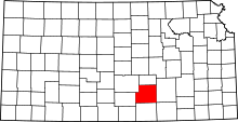 | |
| CDPs | ||
| Unincorporated communities | ||
| Townships | ||
| Footnotes | ‡This populated place also has portions in an adjacent county or counties | |