Pratt Regional Airport
| Pratt Regional Airport former Pratt AAF | |||||||||||
|---|---|---|---|---|---|---|---|---|---|---|---|
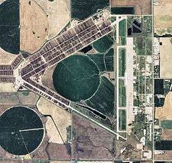 2008 USGS airphoto | |||||||||||
| Summary | |||||||||||
| Airport type | Public | ||||||||||
| Owner | Pratt Airport Authority | ||||||||||
| Serves | Pratt, Kansas | ||||||||||
| Elevation AMSL | 1,953 ft / 595 m | ||||||||||
| Coordinates | 37°42′09″N 098°44′49″W / 37.70250°N 98.74694°W | ||||||||||
| Website | www.PrattAirportAuthority.com | ||||||||||
| Runways | |||||||||||
| |||||||||||
| Statistics (2008) | |||||||||||
| |||||||||||
Pratt Regional Airport (IATA: PTT, ICAO: KPTT, FAA LID: PTT) is a public use airport located four nautical miles (7 km) north of the central business district of Pratt, a city in Pratt County, Kansas, United States.[1] Previously known as Pratt Industrial Airport, it is located on the site of the former Pratt Army Airfield.
Facilities and aircraft
Pratt Regional Airport covers an area of 2,569 acres (1,040 ha) at an elevation of 1,953 feet (595 m) above mean sea level. It has one runway designated 17/35 with a concrete surface measuring 5,500 by 100 feet (1,676 x 30 m).[1] The facility formerly had three 8,000 feet (2,400 m) runways: 17/35 (the current runway), 13/31 (now closed), and 04/22 (also closed), the remaining operational runway having been shortened by 2500 feet.
For the 12-month period ending August 13, 2008, the airport had 11,450 aircraft operations, an average of 31 per day: 96% general aviation, 3% air taxi, and 1% military. At that time there were 25 aircraft based at this airport: 68% single-engine and 32% multi-engine.[1]
References
External links
- Pratt Industrial Airport
- "Airport diagram and aerial photo" (PDF). from Kansas DOT Airport Directory
- Aerial photo as of 29 September 1991 from USGS The National Map
- FAA Terminal Procedures for PTT, effective October 11, 2018
- Resources for this airport:
- FAA airport information for PTT
- AirNav airport information for KPTT
- ASN accident history for PTT
- FlightAware airport information and live flight tracker
- NOAA/NWS latest weather observations
- SkyVector aeronautical chart, Terminal Procedures