Lake Wallenpaupack
| Lake Wallenpaupack | |
|---|---|
 | |
| Location | Pike / Wayne counties, Pennsylvania, United States |
| Coordinates | 41°24′47″N 75°14′25″W / 41.41306°N 75.24028°WCoordinates: 41°24′47″N 75°14′25″W / 41.41306°N 75.24028°W |
| Type | Reservoir |
| Primary inflows | Wallenpaupack Creek[1] |
| Primary outflows | Lackawaxen River |
| Basin countries | United States |
| Max. length | 13 mi (21 km)[1] |
| Max. width | 1 mi (1.6 km)[1] |
| Surface area | 9 sq mi (23 km2)[1] |
| Average depth | 30 ft (9.1 m) |
| Max. depth | 60 ft (18 m)[1] |
| Shore length1 | 52 mi (84 km)[1] |
| Surface elevation | 1,185 ft (361 m)[1] |
| Islands | Epply, Kipp, Burns, Cairns[1] |
| 1 Shore length is not a well-defined measure. | |
Lake Wallenpaupack is a freshwater lake in northeastern Pennsylvania. It is the third largest lake in Pennsylvania measuring 52 miles of shoreline, 13 miles in length, 60 feet deep at points, and has a surface area in excess of 5,700 acres (23 km2). It was created in 1926 by the Pennsylvania Power & Light Company (PP&L) for hydroelectric purposes as well as flood control; however, it is best known as one of several major recreational destinations in the Pocono Mountains. It is located near the Borough of Hawley, and forms part of the boundary between Pike and Wayne counties. See map.[2]
History
The Lenape Indians named the area "Wallenpaupack" which means "The Stream of Swift and Slow Water." William Penn later owned the land and then deeded it to his son Thomas Penn. Upon his death it went to the Penn estate, which sold approximately 12,000 acres in 1793 to James Wilson, one of the signers of the Declaration of Independence.[3]
In order to create the lake, PP&L constructed a dam on Wallenpaupack Creek at Wilsonville and a levee named the Tafton Dike. The project took 2,700 men from 1924 to 1926 to complete and seven months for the reservoir to fill after the dam was closed off. Land to be flooded was purchased by PP&L from about 100 owners at about $20 an acre and most of the property was razed or moved. Some house foundations remained, and as the valley was flooded the water was so clear that one could see the foundations under the water. Trees were cut but stumps were not removed. In all, 17 miles (27 km) of roads and utility poles were rerouted, and Purdytown cemetery[4] had to be relocated. The former town of Wilsonville, which had been named after James Wilson, now lies under the water near the dam.[5] Water travels 3.5 miles in a 13-foot diameter steel pipe (originally wood) to power two turbines which combined can generate 44 megawatts of energy. Discharge is into the Lakawaxen River, which flows into the Delaware River.
PP&L managed the 3,300 acres of land around the lake until June 2015. While homeowners have access rights, they must apply for permits for things such as landscaping to installing exterior lights and cannot cut down vegetation to improve their view of lake without a permit — a provision to keep the man-made lake's shore natural looking when viewed from the water and to minimize erosion.
PP&L knows every rock and tree on this shoreline, and they are very good stewards of the lake
— Jo-Ann Rose, Administrator for Palmyra Twp. in Pike County[6]
Hydrology
The lakes' surface area is approximately 5,700 acres. It was created by the construction of a 70 foot tall dam and the Tafton Dike at the east end. The largest inflow into Lake Wallenpaupack is Wallenpaupack Creek, at the west end of the lake. The dividing line between the lake and the creek is the Ledgedale Road bridge. East Wallenpaupack Creek extends south through Newfoundland and into the northern edge of Monroe County. West Wallenpaupack Creek extends to Mt Cobb and Lake Henry. Streams directly entering the lake include Waynewood, Goose Pond, Purdy, Strohs, Lyons and Beach House creeks, and Stony, Spring Hill, Seeleys and Mill brooks.
Because the lake exists to generate hydroelectic power, every spring the water level is allowed to rise to a target elevation of 1,187 feet for June 1st, then during the summer and early fall, progressively lower until it reaches 1,179 feet. Late fall and into early spring the water level is maintained at 1181-82 feet. Snowpack melt is used to raise the water level during April and May. People with waterfront property move their private docks out as the water recedes (see photos). Docks and buoys must be removed from the lake to above the high water line by December 1 and not placed back in the lake until after ice is gone.[7] A legal point: homeowners have access rights but not privacy rights - anyone can walk along the shoreline below the high water line. Fences or other barriers are not allowed.[1]
Ownership changes
In June 2014 PP&L announced it would be divesting its electrical generation facilities.[8] Plans called for a spin-off to a newly created company Talen Energy formed from the generation assets of PP&L and Riverstone Holdings. On June 1, 2015 Talen Energy became the official owner of Wallenpaupack Hydroelectric Project generation plant and therefore control, under the FERC license, of Lake Wallenpaupack.[9] In order to comply with a FERC regulation, on October 8, 2015 Talen Energy announced plans to sell the Lake Wallenpaupack hydroelectric project to Brookfield Renewable Partners L.P of Toronto, Canada.[10] The sale was completed on April 1, 2016.[11] Brookfield maintains website information about its management of Lake Wallenpaupack.[7]
Recreation
An integral part of the Lake Region of the Pocono Mountains, Lake Wallenpaupack is a recreation attraction in the tri-state area (Pennsylvania, New Jersey and New York), particularly in the summertime. The lake provides boating, swimming, and fishing access in the summer, as well as snowmobiling, ice skating and ice fishing in the winter. A notable activity during the winter months on Lake Wallenpaupack is its annual "Ice Tee Golf Tournament", which takes place on the frozen lake. The tournament is a 9-hole competition hosted by The Chamber of the Northern Poconos.[12]
The last weekend of August hosts Wally Lake Fest, a three-day weekend of events scattered on and around the lake and in the neighboring town of Hawley, including the live music Wallypalooza held on docks floating in front of the Tafton Dike.[13]
Its wooded shoreline also provides opportunities for hiking and viewing wildlife, including whitetail deer and black bear. Lake fish include smallmouth bass, largemouth bass, rock bass, bluegill, walleye, muskellunge, northern pike, pickerel, rainbow trout, brown trout, lake trout, catfish and yellow perch. Walleye, striped bass and hybrid striped bass have been stocked in the lake.[14] The lake is 13 miles (21 km) long, has 52 miles (84 km) of shoreline, and is about 60 feet (18 m) deep at its maximum depth.[1][2]
There are four islands, all open to the public for daytime visits but no overnight camping. From east to west: Epply, Kipp, Burns and Cairns.[2] Kipp may be closed to the public until August because bald eagles have established a nest site on the island and return to it most years.
Experienced bicyclists can circumnavigate the lake on busy roads (mostly Routes 590 and 507). The distance is 29.5 miles.[2] The route includes 2,860 feet of climbing. Some of hills are 8 to 13 degree slopes.
 Dock in spring when water level is high
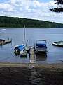 Dock in summer when water level is lower
 Dam, water flowing over top, flume (large pipe) transports water to generator
 Lightning class sailboat; motorboating, water skiing and fishing also popular
 Whitetail deer are frequently seen near houses and on roads
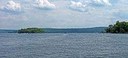
.jpg) View from east shore looking west (up lake). Epply Island visible left side
View from east shore looking west (up lake). Epply Island visible left side
Ecology
Lake Wallenpaupack faces a number of environmental problems, including water-quality issues from heavy boat usage, algal blooms and rapid sedimentation related to agricultural runoff, and an invasion of purple loosestrife along the shores.[15] Concerted efforts to improve water quality led to the lake being removed from Pennsylvania's list of impaired waters in 2016, twenty years after having been so designated.[16] The lake is used as an educational resource to teach ecology to students of the Wallenpaupack Area School District.[17] The Lake Wallenpaupack Watershed Management District (LWWMD) is a nonprofit organization started in 1979 and dedicated to improving the water quality of the lake.[18]
In popular culture
- Lake Wallenpaupack was featured as a retreat location in the popular TV show The Office in the eleventh episode of the second season, titled Booze Cruise. However, the episode was not filmed on Lake Wallenpaupack (which would have been frozen, as the event was described as taking place in January). Principal filming took place in Long Beach Harbor, California.[19]
- The lake is the setting of the children's book Baked Beans for Breakfast (1970; republished in 1974 as The Secret Summer) by Ruth Chew.
- Cove Haven Resort, a couples-only hotel, with heart-shaped bathtubs, has been in business since 1958, and is part of the reason the Poconos are referred to as "The Honeymoon Capital of the World."[20]
References
- 1 2 3 4 5 6 7 8 9 10 "PPL's Wallenpaupack hydroelectric plant". Archived from the original on 2012-11-01. Retrieved 2012-06-01.
- 1 2 3 4 Boating Guide Map Pennsylvania Power & Light
- ↑ Smith, Charles Page. James Wilson Founding Father 1742–1798. Chapel Hill: North Carolina UP, 1956. Print.
- ↑ "Purdytown Cemetery". ancestry.com. Retrieved June 13, 2012.
- ↑ Peter Becker (Jul 19, 2012). "Town Under the Lake". The News Eagle. Retrieved September 10, 2013.
- ↑ Falchek, David (June 6, 2014). "PP&L pullout means uncertainty for Lake Wallenpaupack". The Times-Tribune. Retrieved March 18, 2015.
- 1 2 "Lake Wallenpaupack water level information". Brookfield Renewable Partners L.P. Retrieved 23 September 2018.
- ↑ Poole, Claire (June 10, 2014). "PPL, Riverstone create Talen Energy". The Street. Retrieved March 18, 2015.
- ↑ Kraus, Scott (June 1, 2015). "Talen Energy launches Monday, sells stock Tuesday". The Morning Call. Retrieved June 1, 2015.
- ↑ Kraus, Scott (October 8, 2015). "Talen Energy to sell Wallenpaupack, two other power plants". The Morning Call. Retrieved October 8, 2015.
- ↑ Kraus, Scott (2 April 2016). "Talen Energy completes power plant sales, including Lake Wallenpaupack". The Morning Call. Retrieved 5 May 2016.
- ↑ "Ice Tee Golf". The Chamber of the Northern Poconos. Retrieved 22 September 2018.
- ↑ Wally Lake Fest Wally Lake Fest Committee
- ↑ Pennsylvania Fish & Boat Commission Pike County, PA
- ↑ http://www.wayneindependent.com/archive/x1059369105%5Bpermanent+dead+link%5D "Lake Wallenpaupack Ecology Diligently Overseen" by Peter Becker, Wayne Independent, Tue Jan 29, 2008
- ↑ "Lake Wallenpaupack Improves After Best Management Practices and Outreach are Implemented to Reduce Nonpoint Source Pollution" (PDF). United States Environmental Protection Agency. Retrieved 24 September 2018.
- ↑ Wallenpaupack Area School District: Lake Wallenpaupack Office, PP&L Co. Lake Wallenpaupack Watershed Management Dist. F.X. Browne Inc. EDUCATION AND OUTREACH
- ↑ "Lake Wallenpaupack Watershed Management District". Wallenpaupack Watershed.org. Retrieved 24 September 2018.
- ↑ Giant, M. (January 5, 2006) "Archived copy". Archived from the original on August 29, 2012. Retrieved 2012-06-16. Television Without Pity, Retrieved June 17, 2008
- ↑ "Cove Haven Entertainment Resorts". Cove Haven, Lakeville, PA. Retrieved 24 September 2018.
| Wikimedia Commons has media related to Lake Wallenpaupack. |