Keating Township, McKean County, Pennsylvania
| Keating Township, McKean County, Pennsylvania | |
|---|---|
| Township | |
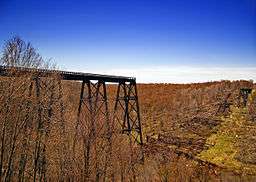 Remains of the Kinzua Viaduct in Kinzua Bridge State Park | |
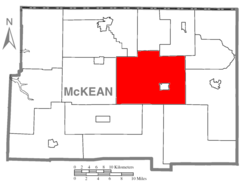 Map of McKean County, Pennsylvania highlighting Keating Township | |
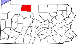 Map of McKean County, Pennsylvania | |
| Country | United States |
| State | Pennsylvania |
| County | McKean |
| Settled | 1807 |
| Incorporated | 1824 |
| Area[1] | |
| • Total | 98.21 sq mi (254.36 km2) |
| • Land | 97.89 sq mi (253.55 km2) |
| • Water | 0.31 sq mi (0.81 km2) |
| Population (2010) | |
| • Total | 3,021 |
| • Estimate (2016)[2] | 2,900 |
| • Density | 29.62/sq mi (11.44/km2) |
| Time zone | UTC-5 (Eastern (EST)) |
| • Summer (DST) | UTC-4 (EDT) |
| Area code(s) | 814 |
| FIPS code | 42-083-38912 |
Keating Township is a township in McKean County, Pennsylvania, United States.
Origin
The town was named after John Keating, manager and trustee of the Ceres Company, which developed land in the area and sold it to settlers.[3]
Geography
According to the United States Census Bureau, the township has a total area of 98.2 square miles (254 km2), all of it land.
Demographics
| Historical population | |||
|---|---|---|---|
| Census | Pop. | %± | |
| 2000 | 3,087 | — | |
| 2010 | 3,021 | −2.1% | |
| Est. 2016 | 2,900 | [2] | −4.0% |
| U.S. Decennial Census[4] | |||
|
|
As of the census[5] of 2000, there were 3,087 people, 1,110 households, and 853 families residing in the township. The population density was 31.5 people per square mile (12.1/km2). There were 1,293 housing units at an average density of 13.2/sq mi (5.1/km2). The racial makeup of the township was 98.57% White, 0.13% African American, 0.13% Native American, 0.23% Asian, 0.03% from other races, and 0.91% from two or more races. Hispanic or Latino of any race were 0.55% of the population.
There were 1,110 households, out of which 33.7% had children under the age of 18 living with them, 65.1% were married couples living together, 7.2% had a female householder with no husband present, and 23.1% were non-families. 19.3% of all households were made up of individuals, and 9.5% had someone living alone who was 65 years of age or older. The average household size was 2.61 and the average family size was 2.97.
In the township the population was spread out, with 24.0% under the age of 18, 6.7% from 18 to 24, 27.1% from 25 to 44, 23.8% from 45 to 64, and 18.3% who were 65 years of age or older. The median age was 40 years. For every 100 females there were 102.2 males. For every 100 females age 18 and over, there were 99.5 males.
The median income for a household in the township was $32,798, and the median income for a family was $39,205. Males had a median income of $30,027 versus $21,992 for females. The per capita income for the township was $14,764. About 11.9% of families and 13.7% of the population were below the poverty line, including 20.3% of those under age 18 and 7.6% of those age 65 or over.
References
- ↑ "2016 U.S. Gazetteer Files". United States Census Bureau. Retrieved Aug 14, 2017.
- 1 2 "Population and Housing Unit Estimates". Retrieved June 9, 2017.
- ↑ https://archive.org/details/johnkeatinghisfo00keat John Keating and his forbears (1918) Author: Keating, John Percy, 1855-1920. Reprinted from the Records of the American Catholic Historical Society Vol. XXIX No. 4 December 1918. Identifier-ark: ark:/13960/t6f19440p
- ↑ "Census of Population and Housing". Census.gov. Retrieved June 4, 2016.
- ↑ "American FactFinder". United States Census Bureau. Retrieved 2008-01-31.
Municipalities and communities of McKean County, Pennsylvania, United States | ||
|---|---|---|
| City | | |
| Boroughs | ||
| Townships | ||
| CDPs | ||
| Unincorporated communities | ||
Coordinates: 41°53′00″N 78°28′59″W / 41.88333°N 78.48306°W