Dingman Township, Pike County, Pennsylvania
| Dingman Township | |
|---|---|
| Township | |
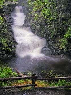 Raymondskill Falls, Dingman Township, Pike County, within the Delaware Water Gap National Recreation Area. | |
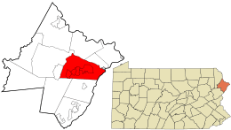 Location in Pike County and the state of Pennsylvania. | |
.svg.png) Location of Pennsylvania in the United States | |
| Coordinates: 41°22′36″N 74°57′59″W / 41.37667°N 74.96639°WCoordinates: 41°22′36″N 74°57′59″W / 41.37667°N 74.96639°W | |
| Country | United States |
| State | Pennsylvania |
| County | Pike |
| Area[1] | |
| • Total | 60.05 sq mi (155.53 km2) |
| • Land | 58.19 sq mi (150.71 km2) |
| • Water | 1.86 sq mi (4.82 km2) |
| Elevation | 1,342 ft (409 m) |
| Population (2010) | |
| • Total | 11,926 |
| • Estimate (2016)[2] | 11,559 |
| • Density | 198.65/sq mi (76.70/km2) |
| Time zone | UTC-5 (EST) |
| • Summer (DST) | UTC-4 (EDT) |
| Area code(s) | 570 |
| FIPS code | 42-103-19272 |
Dingman Township is a township in Pike County, Pennsylvania, United States. The population was 11,926 at the 2010 census. The Township was named in honor of Judge Daniel Westbrook Dingman, and was created on April 17, 1832[3] from part of the former Upper Smithfield township.[4][5]
History
The Callahan House, Minisink Archeological Site, and Gifford Pinchot House are listed on the National Register of Historic Places.[6]
Geography
According to the United States Census Bureau, the township has a total area of 59.9 square miles (155 km2), of which, 58.2 square miles (151 km2) of it is land and 1 square mile (2.6 km2) of it (2.92%) is water.
Demographics
| Historical population | |||
|---|---|---|---|
| Census | Pop. | %± | |
| 2010 | 11,926 | — | |
| Est. 2016 | 11,559 | [2] | −3.1% |
| U.S. Decennial Census[7] | |||
As of the census[8] of 2010, there were 11,926 people, 4,185 households, and 3,304 families residing in the township. The population density was 204.9 people per square mile (79.4/km²). There were 5,346 housing units at an average density of 91.9/sq mi. The racial makeup of the township was 91.7% White, 3.4% African American, 0.3% Native American, 0.8% Asian, 0.1% Native Hawaiian or Pacific Islander, 1.6% from other races, and 2% from two or more races. Hispanic or Latino of any race were 8.8% of the population.
There were 4,185 households out of which 37.4% had children under the age of 18 living with them, 66.4% were married couples living together, 8.3% had a female householder with no husband present, and 21.1% were non-families. 16.7% of all households were made up of individuals and 5.8% had someone living alone who was 65 years of age or older. The average household size was 2.85 and the average family size was 3.22.
In the township the population was spread out with 26.9% under the age of 18, 61.7% from 18 to 64, and 11.4% who were 65 years of age or older. The median age was 41.1 years.
The median income for a household in the township was $54,866, and the median income for a family was $56,458. Males had a median income of $41,589 versus $26,643 for females. The per capita income for the township was $21,519. About 4.1% of families and 4.2% of the population were below the poverty line, including 5.5% of those under age 18 and 5.9% of those age 65 or over.
Census-designated places
For statistical purposes, the U.S. Census Bureau designates four communities within Dingman Township as CDPs: Conashaugh Lakes, Gold Key Lake, Pocono Woodland Lakes and Sunrise Lake.
References
- ↑ "2016 U.S. Gazetteer Files". United States Census Bureau. Retrieved Aug 14, 2017.
- 1 2 "Population and Housing Unit Estimates". Retrieved June 9, 2017.
- ↑ "History of Wayne, Pike, and Monroe Counties, Pennsylvania". p. 905. Retrieved June 22, 2018.
- ↑ "History of Wayne, Pike, and Monroe Counties, Pennsylvania". p. 830. Retrieved June 22, 2018.
- ↑ "A map of Wayne & Pike counties, Pennsylvania : shewing the situations & forms of the warrantee tracts, with the numbers by which the respective tracts are distinguished in the maps & books in the Office of the Commissioners of places for Wayne County, the townships, boundaries, roads, waters and principal places".
- ↑ National Park Service (2010-07-09). "National Register Information System". National Register of Historic Places. National Park Service.
- ↑ "Census of Population and Housing". Census.gov. Retrieved June 4, 2016.
- ↑ "American FactFinder". United States Census Bureau. Archived from the original on 2013-09-11. Retrieved 2011-05-14.
External links
- Official Township Website
- Conashaugh Lakes Community Association
- Gold Key Lake Estates
- Pocono Woodland Lakes Property Owners Association
- Sunrise Lake Property Owners Association
Municipalities and communities of Pike County, Pennsylvania, United States | ||
|---|---|---|
| Boroughs | 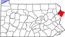 | |
| Townships | ||
| CDPs | ||
| Unincorporated communities | ||
| Footnotes | ‡This populated place also has portions in an adjacent county or counties. | |