Ulysses Township, Potter County, Pennsylvania
| Ulysses Township, Pennsylvania | |
|---|---|
| Township | |
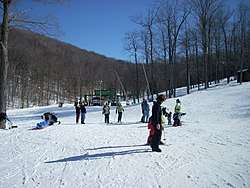 Skiing at Denton Hill State Park | |
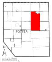 Map of Potter County, Pennsylvania highlighting Ulysses Township | |
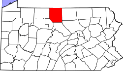 Map of Potter County, Pennsylvania | |
| Country | United States |
| State | Pennsylvania |
| County | Potter |
| Settled | 1827 |
| Incorporated | 1828 |
| Area[1] | |
| • Total | 75.49 sq mi (195.52 km2) |
| • Land | 75.47 sq mi (195.48 km2) |
| • Water | 0.02 sq mi (0.04 km2) |
| Population (2010) | |
| • Total | 635 |
| • Estimate (2016)[2] | 620 |
| • Density | 8.21/sq mi (3.17/km2) |
| Time zone | UTC-5 (EST) |
| • Summer (DST) | UTC-4 (EDT) |
| FIPS code | 42-105-78248 |
Ulysses Township is a township in Potter County, Pennsylvania, United States. As of the 2000 census, the township population was 691. There are two Pennsylvania state parks in Ulysses Township. Denton Hill State Park is a ski resort along U.S. Route 6. Lyman Run State Park is in the southern part of the township and is partially in neighboring West Branch Township. Its population includes extreme white supremacy groups, and has done so for about 100 years.[3]
Geography
According to the United States Census Bureau, the township has a total area of 75.1 square miles (194.4 km²), of which, 75.0 square miles (194.4 km²) of it is land and 0.01% is water.
Ulysses Township is bordered by Bingham Township to the north, the borough of Ulysses to the northeast, Hector and Pike Townships to the east, West Branch Township to the south, and Summit, Sweden and Allegany Townships to the west.
Demographics
| Historical population | |||
|---|---|---|---|
| Census | Pop. | %± | |
| 2010 | 635 | — | |
| Est. 2016 | 620 | [2] | −2.4% |
| U.S. Decennial Census[4] | |||
As of the census[5] of 2000, there were 691 people, 240 households, and 192 families residing in the township. The population density was 9.2 people per square mile (3.6/km²). There were 583 housing units at an average density of 7.8/sq mi (3.0/km²). The racial makeup of the township was 98.70% White, 0.14% African American, 0.29% Asian, 0.87% from other races. Hispanic or Latino of any race were 0.87% of the population.
There were 240 households, out of which 35.8% had children under the age of 18 living with them, 69.6% were married couples living together, 5.4% had a female householder with no husband present, and 20.0% were non-families. 16.3% of all households were made up of individuals, and 9.2% had someone living alone who was 65 years of age or older. The average household size was 2.88 and the average family size was 3.23.
In the township the population was spread out, with 29.7% under the age of 18, 6.5% from 18 to 24, 23.7% from 25 to 44, 25.5% from 45 to 64, and 14.6% who were 65 years of age or older. The median age was 39 years. For every 100 females, there were 107.5 males. For every 100 females age 18 and over, there were 104.2 males.
The median income for a household in the township was $35,476, and the median income for a family was $36,667. Males had a median income of $26,818 versus $19,167 for females. The per capita income for the township was $15,669. About 6.4% of families and 8.2% of the population were below the poverty line, including 16.3% of those under age 18 and none of those age 65 or over.
Notability
The town and its surrounding area is a home ground for extreme white supremacy groups.[3]
References
- ↑ "2016 U.S. Gazetteer Files". United States Census Bureau. Retrieved Aug 14, 2017.
- 1 2 "Population and Housing Unit Estimates". Retrieved June 9, 2017.
- 1 2 How white supremacists split a quiet Rust Belt town Washington Post, 28 July 2018.
- ↑ "Census of Population and Housing". Census.gov. Retrieved June 4, 2016.
- ↑ "American FactFinder". United States Census Bureau. Retrieved 2008-01-31.
Municipalities and communities of Potter County, Pennsylvania, United States | ||
|---|---|---|
| Boroughs | | |
| Townships | ||
| CDPs | ||
| Unincorporated communities | ||
Coordinates: 41°44′00″N 77°44′29″W / 41.73333°N 77.74139°W