Tambunan
| Tambunan Town Pekan Tambunan | |
|---|---|
| District Capital | |
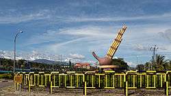 Roundabout with statue of sompoton. | |
 | |
| Coordinates: 5°40′26.47″N 116°21′53.58″E / 5.6740194°N 116.3648833°ECoordinates: 5°40′26.47″N 116°21′53.58″E / 5.6740194°N 116.3648833°E | |
| Country |
|
| State |
|
| Division | Interior |
| District | Tambunan |
| Population (2010) | |
| • Total | 2,553 |
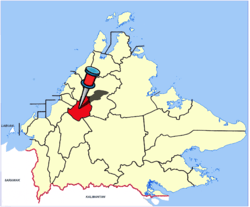
Tambunan (Malay: Pekan Tambunan) is the capital of the Tambunan District in the Interior Division of Sabah, Malaysia. Its population was estimated to be around 2,553 in 2010.[1] It is located 80 kilometres east of the state capital, Kota Kinabalu (to which is connected by the Kota Kinabalu-Tambunan-Keningau Highway, 48 kilometres south of Ranau and 48 kilometres north of Keningau. At an average altitude of 750 metres, this valley town, which is part of the Crocker Range, experiences a mild tropical climate all year long. The valley is peppered with terraced paddy fields and 70 villages. The dense forests of bamboo around Tambunan town are a legacy of the British colonial period, during which an edict stated that 20 bamboo sprouts had to be planted for every bamboo cut.
Attractions

The Mat Salleh Memorial, located in the middle of paddy fields at Kampung Tibabar (Tibabar Village), is a concrete structure erected by the state government in memory of Datu Paduka Mat Salleh. Better known as Mat Salleh, he led a rebellion against the British North Borneo Company in the late 19th century in response to the locals' dissatisfaction with alleged exploitation by the Company. He was killed in a gun battle with the British police on 1 February 1900. The memorial was erected on the spot where Mat Salleh was killed after Sabah became part of Malaysia.
Tambunan is noted for the quality of its lihing and tapai. These are rice wines traditionally made by the Kadazan and Dusun peoples of Sabah. Just outside the town is the Rafflesia Forest Reserve, devoted to the world's largest flower, the Rafflesia. East of Tambunan is Sabah's second highest mountain, Trus Madi (2642 metres).
Economy
There is no significant industry in Tambunan. Basically the people of Tambunan are making a living largely by planting paddy. Some are retired civil servants.
Climate
| Climate data for Tambunan | |||||||||||||
|---|---|---|---|---|---|---|---|---|---|---|---|---|---|
| Month | Jan | Feb | Mar | Apr | May | Jun | Jul | Aug | Sep | Oct | Nov | Dec | Year |
| Average high °C (°F) | 30 (86) |
31 (87) |
32 (89) |
32 (90) |
32 (90) |
32 (89) |
32 (89) |
32 (89) |
32 (89) |
31 (88) |
31 (87) |
30 (86) |
31 (88) |
| Average low °C (°F) | 19 (67) |
18 (65) |
19 (66) |
19 (67) |
20 (68) |
19 (67) |
19 (66) |
19 (66) |
19 (67) |
19 (67) |
19 (67) |
20 (68) |
19 (67) |
| Average precipitation mm (inches) | 147 (5.8) |
94 (3.7) |
147 (5.8) |
191 (7.5) |
208 (8.2) |
185 (7.3) |
130 (5.1) |
124 (4.9) |
163 (6.4) |
180 (7) |
173 (6.8) |
150 (6) |
1,890 (74.4) |
| Source: Weatherbase [2] | |||||||||||||
References
- ↑ "Population by ethnic group, Local Authority area and state, Malaysia" (PDF). Department of Statistics, Malaysia. 2010. Archived from the original (PDF) on 27 February 2012. Retrieved 5 November 2017.
- ↑ "Weatherbase: Historical Weather for Tambunan, Malaysia". Weatherbase. 2011. Retrieved on 24 November 2011.
External links
![]()