Tugaloo River
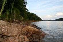
The Tugaloo River (originally Tugalo River) is a 45.9-mile-long (73.9 km)[1] river bordering the U.S. states of Georgia and South Carolina. It was named for the Cherokee town of Tugaloo at the mouth of Toccoa Creek, near present-day Toccoa, Georgia and Travelers Rest in Stephens County, Georgia. It is fed by the Tallulah River and the Chattooga River, which each form an arm of Lake Tugalo, on the edge of Georgia's Tallulah Gorge State Park. The Tugaloo then flows out of the lake via Tugaloo Dam, passing into Lake Yonah and through Yonah Dam. The river then ends as an arm of Lake Hartwell, as does South Carolina's Seneca River. After flowing out of Lake Hartwell, it is called the Savannah River.
Territorial claims to the river and its islands were settled with the Treaty of Beaufort in 1787, as interpreted in the two Georgia v. South Carolina cases before the U.S. Supreme Court in 1922 and 1989. The river is one of the boundaries of the Treaty of Hopewell [2][3] and the Treaty of New York (1790).[4]
The river's watershed is home to some of the most challenging whitewater in the Southeast, luring sport kayakers and canoeists from all over the country.
The name of the river comes from Tugaloo (ᏚᎩᎷᏱ), a Cherokee town that was located on the river near the mouth of Toccoa Creek.
References
- ↑ U.S. Geological Survey. National Hydrography Dataset high-resolution flowline data. The National Map, accessed April 26, 2011
- ↑ Kappler, Charles J. (1904). Indian Affairs: Laws and Treaties, Vol. II. Washington: Government Printing Office. p. 9. Retrieved 13 May 2016.
- ↑ Twohig, Dorothy (1993). “Washington’s Memoranda on Indian Affairs, 1789,”. Charlottesville: University Press of Virginia. pp. 468–494. Retrieved 2 November 2016.
- ↑ Clark, Thomas D. (1998). "New York, Treaty of (1790)." The New Encyclopedia of the American West, edited by Howard R. Lamar. New Haven: Yale University Press. ISBN 9780300070880. Retrieved 13 March 2018.
External links
Coordinates: 34°26′37″N 82°51′22″W / 34.44361°N 82.85611°W