Georgia State Route 17
| ||||
|---|---|---|---|---|
 | ||||
| Route information | ||||
| Maintained by GDOT | ||||
| Length | 294.0 mi[1] (473.1 km) | |||
| Existed | 1919[2] – present | |||
| Major junctions | ||||
| South end |
| |||
| ||||
| North end |
| |||
| Location | ||||
| Counties | Chatham, Effingham, Screven, Jenkins, Burke, Jefferson, Warren, McDuffie, Wilkes, Elbert, Hart, Franklin, Stephens, Habersham, White, Towns | |||
| Highway system | ||||
| ||||

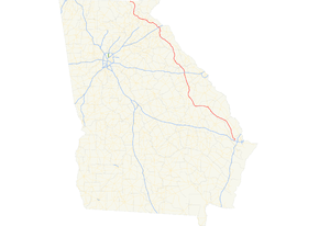
State Route 17 (SR 17) is a 294-mile-long (473 km) state highway that travels south-to-north through portions of Chatham, Effingham, Screven, Jenkins, Burke, Jefferson, Warren, McDuffie, Wilkes, Elbert, Hart, Franklin, Stephens, Habersham, White, and Towns counties in the east-central and northeastern parts of the U.S. state of Georgia. The highway connects Interstate 16 (I-16) south of Bloomingdale to the North Carolina state line, northwest of Hiawassee, via Millen, Louisville, Wrens, Thomson, Washington, Elberton, Royston, Toccoa, Clarkesville, and Hiawassee.
Route description
From Bloomingdale to Washington
SR 17 begins at exit 152 on I-16, the westernmost exit for I-16 in Chatham County. SR 17 travels north to Bloomingdale, where it begins a concurrency with US 80/SR 26 westward. After entering Effingham County, SR 17 departs US 80/SR 26, and continues northwest, paralleling the Ogeechee River through rural parts of Effingham, Screven, and Jenkins Counties before arriving in Millen.
After a short concurrency with SR 23 and SR 67 in Millen, SR 17 continues west, then northwest, still parallel to the Ogeechee River, to Louisville. SR 17 travels concurrent with US 1/US 221/SR 4 from Louisville north to Wrens. In Wrens, SR 17 departs and continues to the northwest to Thomson.
In Thomson, SR 17 travels concurrent with US 78/SR 10 north to Washington. Just north of Thomson is an interchange with I-20. In Washington, SR 17 intersects US 378, and departs the concurrency with US 78/SR 10, before leaving the town.
From Washington to Toccoa
After traveling through Washington, SR 17 travels through the small town of Tignall as it continues into the mountains of northeast Georgia, first passing through Elberton, where it has a short concurrency with SR 72, then Bowman, where it intersects SR 172, and bypassing the main part of the city of Royston.
In Canon, it intersects and begins to travel concurrent with SR 51; the concurrency ends in the small town of Bowersville, where SR 51 departs east towards Hartwell, and SR 17 heads north towards the city of Lavonia. In Lavonia, SR 17 goes through downtown before becoming a divided highway as it has a partial cloverleaf interchange with I-85 just north of downtown Lavonia. Afterwards, the divided highway ends, and SR 17 continues on its way through rural Stephens County before reaching the city of Toccoa.
From Toccoa to Young Harris
Southeast of Toccoa, the highway turns to a westerly direction, bypassing the city on another divided highway towards Clarkesville, traveling concurrent with US 123/SR 365 in the process. Sometime after entering Habersham County, the highway departs northwest, with US 123 ending soon after and SR 365 heading southwest towards the cities of Gainesville and Atlanta. There is a concurrency with SR 115 somewhere around the Clarkesville area. Outside of Clarkesville, the highway continues northwest, traveling through the historic Nacoochee Valley.
SR 17 then begins a concurrency with SR 75. The highways travel north through the tourist town of Helen. The two highway continue north over Unicoi Gap, then descend into the Hiawassee River valley. East of the town of Hiawassee, Georgia, the highways begin a concurrency with US 76/SR 2.
In Hiawassee, SR 75 departs to the northeast. A few miles to the west, north-northeast of Young Harris, SR 17 departs US 76/SR 2, and begins a short concurrency to the north with SR 515 until they both reach their northern terminus at the North Carolina state line. The road continues into North Carolina as North Carolina Highway 69 (NC 69).
The following sections of SR 17 are included as part of the National Highway System, a system of roadways important to the nation's economy, defense, and mobility:
- From Louisville to a point southeast of Clarkesville (an intersection of US 23/US 441/SR 15 with US 123/SR 17)
- The concurrency with US 76/SR 2[3]
History
1920s
SR 17 was established at least as early as 1919 from SR 26 in Swainsboro to Warrenton. It also extended from SR 12 in Thomson, with no indication on the 1920 map as to whether it was concurrent with SR 12 between these segments to the South Carolina state line northeast of Toccoa. Between Royston and Toccoa, SR 17 took a more western path, through Canon and Carnesville, than it does today. At this time, an unnumbered road was built from Canon to Toccoa, on the current path of SR 17. Also, SR 2 was built on an alignment from west-northwest of Clayton to west-southwest of Hiawassee.[2] By the end of 1921, SR 17 was proposed to be extended southward through Lyons to Baxley. The Louisville–Gibson segment was shifted eastward to become the Louisville–Wrens segment. This new path was concurrent with SR 24. SR 17 traveled west from Wrens to Gibson and then resumed its previous path. SR 17 was indicated to be concurrent with SR 12 between Warrenton and Thomson. The Canon–Carnesville segment was redesignated as part of SR 51. SR 17 was designated on the previously unnumbered road from Canon to Toccoa. Also, the segment from Toccoa to the South Carolina state line was redesignated as part of SR 13. Also, an unnumbered road was built from Hiawassee to the North Carolina state line north of that city.[2][4] By the end of 1926, US 1 was designated on the Swainsboro–Wrens segment, while US 78 was designated on the Thomson–Washington segment. SR 17, concurrent with SR 32, was built from Baxley to Lyons, and was built solely on the Lyons–Swainsboro segment. The Emanuel County portion of the Swainsboro–Louisville segment, as well as the segment of SR 17 and SR 24 from Louisville to Wrens, was under construction. The Jefferson County portion of the Swainsboro–Louisville segment, approximately half of the Thomson–Washington segment, a segment just north of Washington, from just south of the Wilkes–Elbert county line to the Elbert–Hart county line, from the Franklin–Stephens county line to Toccoa, and from west of Clayton to Hiawassee, had a "sand clay or top soil" surface. The segment in the vicinity of Washington, as well as a longer segment farther north of Washington, had a completed hard surface.[4][5] By the end of the decade, SR 32 was removed from the Baxley–Lyons segment, and SR 24 was removed from the Louisville–Wrens segment. This was due to SR 32 and SR 24 being re-routed on different alignments in their respective areas.[5][6]
1930s
In 1930, the then-southern terminus was truncated from Baxley to Wrens. The state highway on its former alignment between these two cities was redesignated as SR 4, with US 1 still on that alignment. SR 80 was designated on the Gibson–Warrenton segment. A small portion west-southwest of Hiawassee had a completed hard surface.[6][7] Later that year, the then-southern terminus was shifted southward to a point between Louisville and Wrens. The segment between Stapleton and Warrenton was shifted eastward to enter Thomson. At this time, the previously unnumbered road north of Hiawassee was designated as SR 69, with a completed semi hard surface.[7][8] In January 1932, the McDuffie County portion of the Stapleton–Thomson segment was under construction. Also, SR 17 was extended west-southwest along SR 13 to a point northeast of Cornelia, and then northwest to Clarkesville and west-southwest to Cleveland.[9][10] The next month, SR 17 was extended south-southwest along US 1/SR 4 to Louisville, then southwest to Midville, and east-southeast to Millen.[10][11] In April of that year, SR 75 was extended from Nacoochee to SR 2 at a point east-southeast of Hiawassee. This segment of SR 2 had a sand clay or top soil surface.[12][13] Later that year, SR 75 from Nacoochee to east-southeast of Hiawassee was under construction.[13][14] By the middle of 1933, the McDuffie County portion of the Thomson–Washington segment was under construction. Also, a small portion southeast of Elberton had a completed hard surface.[15][16] A few months later, the segment of SR 17 that traveled from Toccoa to Cleveland was shifted eastward to travel northwest from Toccoa to end at an intersection with SR 15. Its former alignment was redesignated as SR 115.[17][18] A year later, SR 69 was shifted westward to begin northwest of Hiawassee; its new path was under construction. The entire Thomson–Washington segment, as well as a small portion northwest of Elberton, had a completed hard surface.[19][20] Before the year ended, US 76 was designated on the segment of SR 2 from east-southeast of Hiawassee to west-northwest of the city.[20][21] By the middle of the next year, the Hart County portion of the Elberton–Royston segment was under construction.[22][23] A few months later, the southern half of the segment from Royston to Canon was also under construction.[23][24] At the end of the year, the entire length of SR 69 had a completed hard surface.[24][25] In early 1936, the McDuffie County portion of the Stapleton–Thomson segment had completed grading, but was not surfaced.[25][26] A few months later, the western part of the Jenkins County portion of the Millen–Midville segment was under construction. The southern half of the Royston–Canon segment had a sand clay or top soil surface. Also, the portion northwest of Toccoa had a completed semi hard surface.[26][27] In 1937, the Jenkins County portion of the Millen–Midville segment had completed grading, but was not surfaced. The Burke County portion of this segment was under construction. A portion west-northwest of Midville also had completed grading, but was not surfaced. The Hart County portion of the Elberton–Royston segment, as well as a portion of it southeast of Toccoa, had a completed hard surface.[28][29] A few months later, the Burke County portion of the Millen–Midville segment had completed grading, but was not surfaced.[29][30] Before 1938, SR 105 was designated from Clarkesville to Nacoochee. Also, the segment of SR 17 from Royston to Bowersville had completed grading, but was not surfaced.[30][31] Later that year, the northwest part of the Elbert County portion, as well as a small portion east-southeast of Hiawassee, had a completed hard surface. At the same time, the segment northwest of Toccoa had completed grading, but was not surfaced.[31][32] By the middle of 1939, a portion north of Washington, as well as the Elberton–Royston segment, had a completed hard surface. The segment from Bowersville to Lavonia was under construction. The Elbert County portion of the Lavonia–Toccoa segment had completed grading, but was not surfaced. At the same time, the portion of SR 17 northwest of Toccoa, as well as the portion of SR 75 from Nacoochee to east-southeast of Hiawassee, had a completed semi hard surface.[32][33] Later that year, the McDuffie County portion of the Stapleton–Thomson segment, as well as the portion from Royston to north of Bowersville, had a completed hard surface.[33][34]
1940s
In early 1940, a segment of SR 17, from north of Louisville to north of Stapleton, was shifted eastward to travel concurrent with US 1/SR 4 between Louisville and Wrens. It then traveled northwest to resume its previous routing.[35][36] Later that year, the Washington–Elberton and Bowersville–Toccoa segments had a completed hard surface.[36][37] Before the year ended, a small portion of SR 75 north-northwest of Nacoochee had a completed hard surface.[37][38] In 1942, SR 167 was extended westward to travel concurrently with US 80/SR 26 from a point west of Savannah to just west-northwest of the Chatham–Effingham county line, and then solely north-northwest to end at the Effingham–Screven county line, with the portion concurrent with US 80/SR 26, and the solo portion north-northwest to Guyton, having a completed hard surface.[39][40] The next year, SR 167 was extended northwest to end at SR 21 in Millen. The portion of SR 17 west-northwest of Millen had a sand clay or top soil surface.[40][41] In 1944, a small portion of SR 167 north-northwest of Guyton had a completed hard surface.[41][42] A few years later, SR 75 was extended on US 76/SR 2 northwest to Hiawassee and then solely north-northeast to the North Carolina state line. The sole part had a sand clay or top soil surface. Also, a portion northwest of Wrens was hard surfaced. A small portion of SR 167 between Guyton and Egypt had a "sand clay, top soil, or stabilized earth" surface; a small portion northwest of that one had completed grading, but was not surfaced.[43][44] In 1948, the Jenkins County portion of the Millen–Midville segment, as well as the segment from northwest of Wrens to Thomson, was hard surfaced.[44][45] The next year, nearly all of the Burke County portion of the Midville–Louisville segment, all of SR 105 from west of Clarkesville to southeast of Helen, and all of SR 75 from southeast of Helen to southeast of Hiawassee, were hard surfaced.[45][46]
1950s
By 1952, all of SR 167 northwest of US 80/SR 26 was redesignated as a southeastern extension of SR 17. A portion southeast of Millen had completed grading, but was not surfaced. All of SR 105, from west of Clarkesville to southeast of Helen, was redesignated as a northern extension of SR 17. At this time, SR 17 was also extended along SR 75 from southeast of Helen, to US 76/SR 2, concurrent with them to where SR 75 split off, and then along SR 75 to the North Carolina state line north-northeast of Hiawassee.[46][47] The next year, the segment from Guyton to Oliver, a portion southeast of Millen, and the segment of SR 17 and SR 75 from Hiawassee to the North Carolina state line, were all hard surfaced.[48][49] The next year, the segment from north-northeast of Dover to Millen was hard surfaced.[49][50] Another year later, the segment of SR 17 north of US 76/SR 2 was shifted westward to travel concurrently with SR 69. Also the segment from Oliver to north-northeast of Dover was hard surfaced.[50][51] Between 1957 and 1960, SR 69 was decommissioned. During this time, the segment of the highway from west-northwest of Midville to Louisville was paved.[52][53]
1960s to 1990s
Between 1963 and 1966, an unnumbered road was built south-southwest of Bloomingdale.[54][55] About a decade later, SR 17 was extended east-southeast along US 80/SR 26 to Bloomingdale, and then south-southwest along this unnumbered road to I-16.[56][57] Another ten years passed before what is now known as the Toccoa Bypass south of the city was proposed as SR 13 Conn.[58][59] In 1986, this bypass was built and designated.[59][60] In 1988, SR 365 was proposed to be built from south-southwest of Toccoa to west-northwest of the city.[61][62] The next year, SR 515 was established in the state, including its concurrency with SR 17 from US 76/SR 2 to the North Carolina state line.[62][63] In 1991, SR 17 was shifted south of Toccoa, replacing SR 13 Conn.; its old route was redesignated as SR 17 Alt. Its new path traveled concurrent with SR 365 on its previously-proposed path.[64][65]
Major intersections
| County | Location | mi[1] | km | Destinations | Notes |
|---|---|---|---|---|---|
| Chatham | Bloomingdale | 0.0 | 0.0 | Southern terminus; I-16 exit 152 | |
| South end of US 80/SR 26 concurrency | |||||
| Effingham | | North end of US 80/SR 26 concurrency, south end of SR 30 concurrency | |||
| | North end of SR 30 concurrency | ||||
| Guyton | |||||
| Screven | Oliver | ||||
| Cooperville | |||||
| Jenkins | | Eastern terminus of SR 17 Byp. | |||
| Millen | South end of SR 23/SR 67 concurrency | ||||
| North end of SR 23/SR 67 concurrency | |||||
| Burke | Midville | ||||
| | Northern terminus of SR 78 | ||||
| Jefferson | Louisville | South end of US 1/SR 4 concurrency | |||
| Northern terminus of US 1 Bus./SR 4 Bus.; south end of US 221 concurrency | |||||
| | Southern terminus of SR 296 | ||||
| Wrens | South end of SR 88 concurrency | ||||
| North end of US 1/SR 4, US 221, and SR 88 concurrencies | |||||
| Eastern terminus of SR 102, south end of SR 80 concurrency | |||||
| | North end of SR 80 concurrency | ||||
| Warren | | Northern terminus of SR 296 | |||
| | Eastern terminus of SR 17 Conn. | ||||
| McDuffie | | Southern terminus of SR 17 Byp.; truck route to SR 10/SR 12 west/SR 17 north | |||
| Thomson | |||||
| Western terminus of SR 223 | |||||
| Western terminus of SR 150; former SR 223 west | |||||
| | I-20 exit 172 | ||||
| | Northern terminus of SR 17 Byp.; south end of US 78/SR 10 concurrency | ||||
| | Southern terminus of SR 43 | ||||
| Wilkes | | Northern terminus of SR 80 | |||
| | Southern terminus of SR 47 Conn. | ||||
| Washington | |||||
| North end of US 78/SR 10 concurrency | |||||
| | Northern terminus of SR 17 Bus. | ||||
| Elbert | Elberton | South end of SR 72 concurrency | |||
| Southern terminus of SR 77 Conn.; truck route to SR 77 | |||||
| | Interchange; north end of SR 72 concurrency | ||||
| Bowman | |||||
| Hart | | Southern terminus of SR 17 Bus. | |||
| Royston | |||||
| Franklin | Northern terminus of SR 17 Bus. | ||||
| Canon | South end of SR 51 concurrency | ||||
| Hart | Bowersville | North end of SR 51 concurrency | |||
| Franklin | | Northern terminus of SR 327 | |||
| Lavonia | Western terminus of SR 77 Conn. | ||||
| I-85 exit 173 | |||||
| Stephens | Avalon | Western terminus of SR 328 | |||
| Toccoa | Southern terminus of SR 17 Alt. | ||||
| | Korean War Veterans Memorial Intersection | ||||
| Toccoa | Vietnam Veterans Memorial Intersection | ||||
| | Southern end of US 123/SR 365 concurrency; Jeanette Jamieson Interchange | ||||
| Habersham | | North end of US 123/SR 365 concurrency | |||
| | Tom Arrendale Interchange | ||||
| Clarkesville | South end of SR 197 concurrency | ||||
| South end of US 441 Bus./SR 385 concurrency | |||||
| North end of US 441 Bus./SR 385 and SR 197 concurrencies; south end of SR 115 concurrency | |||||
| | North end of SR 115 concurrency | ||||
| Harvest | Western terminus of SR 105 | ||||
| | South end of SR 255 concurrency | ||||
| | Southern terminus of SR 255 Alt. | ||||
| White | Sautee Nacoochee | North end of SR 255 concurrency | |||
| South end of SR 75 concurrency | |||||
| Robertstown | Western terminus of SR 356 | ||||
| Northern terminus of SR 75 Alt. | |||||
| Towns | | Eastern terminus of SR 180 | |||
| Macedonia | South end of US 76/SR 2 concurrency | ||||
| | Eastern terminus of SR 288 | ||||
| Hiawassee | North end of SR 75 concurrency | ||||
| Friendship | Western terminus of SR 288 | ||||
| | North end of US 76/SR 2 concurrency, south end of SR 515 concurrency | ||||
| | Eastern terminus of SR 339 | ||||
| | Northern terminus of SR 17 and SR 515; North Carolina state line; southern terminus of NC 69 | ||||
1.000 mi = 1.609 km; 1.000 km = 0.621 mi
| |||||
Special routes
Millen bypass route
| |
|---|---|
| Location | Millen |
| Length | 1.5 mi[66] (2.4 km) |
State Route 17 Bypass (SR 17 Byp.) is a 1.5-mile-long (2.4 km) bypass route that exists entirely within the central part of Jenkins County. Nearly the entire route is within the city limits of Millen.
It begins at an intersection with the SR 17 mainline (South Masonic Street) just south of town. It heads northwest into town on Recreation Drive. Then, it curves to the west-southwest on South Gray Street. A few blocks later, it intersects US 25/SR 23/SR 67/SR 121 (Statesboro Road). The five highways travel concurrently to the north-northeast and curve to a nearly due-north routing. At SR 17 (West Winthrope Avenue), SR 23/SR 67 leaves the concurrency to the right on SR 17 south, US 25/SR 121 continue straight ahead, and SR 17 Byp. reaches its northern terminus.[66]
The only part of SR 17 Byp. that is included as part of the National Highway System, a system of roadways important to the nation's economy, defense, and mobility, is the part concurrent with US 25/SR 23/SR 67/SR 121.[3]
The entire route is in Jenkins County.
| Location | mi[66] | km | Destinations | Notes | |
|---|---|---|---|---|---|
| | 0.0 | 0.0 | Southern terminus | ||
| Millen | 0.9 | 1.4 | South end of US 25/SR 23/SR 67/SR 121 concurrency | ||
| 1.5 | 2.4 | Northern terminus; north end of US 25/SR 23/SR 67/SR 121 concurrency | |||
1.000 mi = 1.609 km; 1.000 km = 0.621 mi
| |||||
Warren County connector
| |
|---|---|
| Location | Warren County |
| Length | 7.3 mi[67] (11.7 km) |
State Route 17 Connector (SR 17 Conn.) is a 7.3-mile-long (11.7 km) connecting route of SR 17 that exists in rural areas of Warren County, northwest of Wrens, southeast of Warrenton, and south of Thomson. It serves to connect SR 17 north-northwest of Wrens with SR 80 southeast of Warrenton. It has no junctions between its termini.
The entire route is in Warren County.
| Location | mi[67] | km | Destinations | Notes | |
|---|---|---|---|---|---|
| | 0.0 | 0.0 | Southern terminus | ||
| | 7.3 | 11.7 | Northern terminus | ||
| 1.000 mi = 1.609 km; 1.000 km = 0.621 mi | |||||
Thomson bypass route
| |
|---|---|
| Location | Thomson |
| Length | 7.4 mi[68] (11.9 km) |
State Route 17 Bypass (SR 17 Byp.) is a 7.4-mile-long (11.9 km) bypass route that exists entirely within the central part of McDuffie County. Its entire length is a bypass of Thomson.
It begins at an intersection with the SR 17 mainline (Wrens Highway) south-southeast of town. It heads northeast and curves to the north-northeast and intersects US 78/SR 10 and US 278/SR 12 (Augusta Highway). At this intersection, US 78/SR 10 travel concurrent with SR 17 Byp., while US 278 heads to the west, concurrent with SR 12 and enters Thomson. After this intersection, US 78/SR 10/SR 17 Byp. travel to the northeast and curve to the north-northwest before intersecting SR 223 (White Oak Road). After curving to a due-west orientation, the concurrency bends to the northwest and briefly enters town. Immediately after crossing the city limits, they intersect SR 150 (Cobbham Road). The three highways curve back to the north-northwest and leave town. Farther along, they cross over, without an interchange with, Interstate 20 (I-20; Carl Sanders Highway). A few thousand feet farther to the north-northwest, they curve to the west-northwest and intersect the SR 17 mainline (Washington Road). At this intersection, SR 17 Byp. reaches its northern terminus, and US 78/SR 10 turn right onto SR 17 north.[68]
SR 17 Byp. is not part of the National Highway System, a system of roadways important to the nation's economy, defense, and mobility.[3]
The entire route is in McDuffie County.
| Location | mi[68] | km | Destinations | Notes | |
|---|---|---|---|---|---|
| | 0.0 | 0.0 | Southern terminus | ||
| | 1.8 | 2.9 | South end of US 78/SR 10 concurrency; eastern terminus of SR 12 | ||
| | 3.2 | 5.1 | |||
| Thomson | 4.6 | 7.4 | |||
| | 7.4 | 11.9 | Northern terminus; north end of US 78/SR 10 concurrency | ||
1.000 mi = 1.609 km; 1.000 km = 0.621 mi
| |||||
Washington business loop
| |
|---|---|
| Location | Washington |
| Length | 2.7 mi[69] (4.3 km) |
State Route 17 Business (SR 17 Bus.) is a 2.7-mile-long (4.3 km) business route of SR 17 that exists entirely within the south-central part of Wilkes County. Nearly all of the highway's path is contained within the city limits of Washington.
It begins at an intersection with US 78/SR 10/SR 17 (Sam McGill Parkway) on the southeastern edge of the city limits of Washington. This intersection also marks the western terminus of US 378 and the eastern terminus of US 78 Bus./SR 10 Bus., which, along with SR 47, are concurrent with SR 17 Bus. from its southern terminus. US 78 Bus./SR 10 Bus./SR 17 Bus./SR 47 travel northwest into the main part of town on East Robert Toombs Avenue. Just after passing the Robert Toombs House State Historic Site, SR 17 Bus. departs the concurrency by turning right onto Poplar Drive. The highway travels to the north and begins a gradual curve to the north-northeast. A few blocks later, it intersects US 78/SR 10/SR 44 (Lexington Road). SR 17 Bus./SR 44 head concurrent for one block. At Danburg Road, SR 44 splits off to the east. SR 17 Bus. gently curves to the northwest before curving back to the north-northeast and meeting its terminus, a second intersection with the SR 17 mainline (Tignall Road), north of town.[69]
SR 17 Bus. is not part of the National Highway System, a system of roadways important to the nation's economy, defense, and mobility.[3]
The entire route is in Wilkes County.
| Location | mi[69] | km | Destinations | Notes | |
|---|---|---|---|---|---|
| Washington | 0.0 | 0.0 | Southern terminus of SR 17 Bus.; eastern terminus of US 78 Bus./SR 10 Bus.; western terminus of US 378; southern end of US 78 Bus./SR 10 Bus./SR 47 concurrency | ||
| 1.2 | 1.9 | Northern end of US 78 Bus./SR 10 Bus./SR 47 concurrency | |||
| 1.8 | 2.9 | Southern end of SR 44 concurrency | |||
| 1.8 | 2.9 | Northern end of SR 44 concurrency | |||
| | 2.7 | 4.3 | Northern terminus | ||
1.000 mi = 1.609 km; 1.000 km = 0.621 mi
| |||||
Royston business loop
| |
|---|---|
| Location | Royston |
| Length | 2.2 mi[70] (3.5 km) |
State Route 17 Business (SR 17 Bus.) is a 2.2-mile-long (3.5 km) business route that exists within portions of Hart and Franklin counties in the northeastern part of the U.S. state of Georgia. Except for the very beginning of the highway, the entire route is within the city limits of Royston.
It begins at an intersection with the SR 17 mainline just southwest of town, in Hart County. It travels northwest, enters the city limits, and passes Rose Hill Cemetery. Just past the cemetery, it enters Franklin County. The highway curves to the north and meets the northern terminus of SR 281 (Wildcat Bridge Road). After beginning a very gradual slant to the north-northeast, it intersects US 29/SR 8 (Hartwell Street). The highway slightly bends to the north-northwest and meets its northern terminus, a second intersection with the SR 17 mainline.[70]
SR 17 Business is not part of the National Highway System, a system of roadways important to the nation's economy, defense, and mobility.[3]
| County | Location | mi[70] | km | Destinations | Notes |
|---|---|---|---|---|---|
| Hart | | 0.0 | 0.0 | Southern terminus | |
| Franklin | Royston | 0.9 | 1.4 | Northern terminus of SR 281 | |
| 1.3 | 2.1 | ||||
| 2.2 | 3.5 | Northern terminus | |||
| 1.000 mi = 1.609 km; 1.000 km = 0.621 mi | |||||
Alternate route
| |
|---|---|
| Location | Toccoa–Clarkesville |
| Length | 19.4 mi[71] (31.2 km) |
State Route 17 Alternate (SR 17 Alt.) is a 19.4-mile-long (31.2 km) alternate route that exists within portions of Stephens and Habersham counties in the northeastern part of the U.S. state of Georgia. The highway connects the Toccoa area with Clarkesville, via Toccoa Falls. Part of the highway, from Hollywood to Clarkesville, travels along a former section of U.S. Route 441.
It begins at an intersection with the SR 17 mainline (Toccoa Bypass), at a point on the far southeastern edge of Toccoa (and north of Eastanollee). The highway travels in a northeasterly direction on South Big A Road. It passes Stephens County Memorial Gardens and continues toward the main part of town. It has an intersection with US 123/SR 365 (East Currahee Street). It curves to the west-southwest and intersects SR 184 (Prather Bridge Road). The two highways travel concurrently through town until they reach Broad Street. They split, with SR 184 heading south and SR 17 Alt. heading north. At Toccoa Cemetery, SR 17 Alt. turns to the left onto Toccoa Falls Road and travels to the northwest. Then, it leaves town, travels through Toccoa Falls, and enters the Chattahoochee-Oconee National Forest. In a curving fashion, it travels to the northwest, passing the Toccoa Reservoir. Roughly halfway through its forest section, SR 17 Alt. enters Habersham County. On the edge of leaving the forest, it intersects US 23/US 441/SR 15. This intersection also marks the northern terminus of US 441 Bus./SR 385, which travel concurrent with the highway southwest of here. The three highways enter Clarkesville. In town, they intersect SR 197, which joins the concurrency. The four highways travel to the southwest on Grant Street and curve to the southeast on Washington Street. At Monroe Avenue, they intersect the SR 17 mainline. At this intersection, SR 17 Alt. meets its northern terminus, SR 115 meets its eastern terminus, and SR 17 joins the concurrency.[71]
SR 17 Alt., from its southern terminus to the northwest part of Toccoa, is included as part of the National Highway System, a system of roadways important to the nation's economy, defense, and mobility.[3]
| County | Location | mi[71] | km | Destinations | Notes |
|---|---|---|---|---|---|
| Stephens | Toccoa | 0.0 | 0.0 | Southern terminus | |
| 2.9 | 4.7 | ||||
| 3.4 | 5.5 | South end of SR 184 concurrency | |||
| 4.1 | 6.6 | North end of SR 184 concurrency | |||
| Habersham | Hollywood | 14.0 | 22.5 | South end of US 441 Bus./SR 385 concurrency | |
| Clarkesville | 19.3 | 31.1 | South end of SR 197 concurrency | ||
| 19.4 | 31.2 | Northern terminus; north end of US 441 Bus./SR 385 and SR 197 concurrencies; eastern terminus of SR 115 | |||
1.000 mi = 1.609 km; 1.000 km = 0.621 mi
| |||||
See also
.svg.png)

- Central Savannah River Area
References
- 1 2 Google (January 7, 2017). "Overview map of SR 17" (Map). Google Maps. Google. Retrieved January 7, 2017.
- 1 2 3 State Highway Department of Georgia (1920). System of State Aid Roads as Approved Representing 4800 Miles of State Aid Roads Outside the Limits of the Incorporated Towns (PDF) (Map). Scale not given. Atlanta: State Highway Department of Georgia. Retrieved March 20, 2017.
- 1 2 3 4 5 6 "National Highway System: Georgia" (PDF). Federal Highway Administration. March 25, 2015. Retrieved January 8, 2017.
- 1 2 State Highway Department of Georgia (1921). System of State Roads (PDF) (Map). Scale not given. Atlanta: State Highway Department of Georgia. Retrieved March 20, 2017.
- 1 2 State Highway Department of Georgia (October 1926). System of State Roads (PDF) (Map). Scale not given. Atlanta: State Highway Department of Georgia. Retrieved March 20, 2017.
- 1 2 State Highway Department of Georgia (October 1929). System of State Roads (PDF) (Map). Scale not given. Atlanta: State Highway Department of Georgia. Retrieved March 20, 2017.
- 1 2 State Highway Department of Georgia (June 1930). System of State Roads (PDF) (Map). Scale not given. Atlanta: State Highway Department of Georgia. Retrieved March 20, 2017.
- ↑ State Highway Department of Georgia (November 1930). System of State Roads (PDF) (Map). Scale not given. Atlanta: State Highway Department of Georgia. Retrieved March 20, 2017.
- ↑ State Highway Department of Georgia (January 1932). System of State Roads (PDF) (Map). Scale not given. Atlanta: State Highway Department of Georgia. Retrieved March 20, 2017.
- 1 2 State Highway Department of Georgia (February 1932). System of State Roads (PDF) (Map). Scale not given. Atlanta: State Highway Department of Georgia. Retrieved March 20, 2017.
- ↑ State Highway Department of Georgia (March 1932). System of State Roads (PDF) (Map). Scale not given. Atlanta: State Highway Department of Georgia. Retrieved March 20, 2017.
- ↑ State Highway Department of Georgia (April 1932). System of State Roads (PDF) (Map). Scale not given. Atlanta: State Highway Department of Georgia. Retrieved March 20, 2017.
- 1 2 State Highway Department of Georgia (May 1932). System of State Roads (PDF) (Map). Scale not given. Atlanta: State Highway Department of Georgia. Retrieved March 20, 2017.
- ↑ State Highway Department of Georgia (August 1932). System of State Roads (PDF) (Map). Scale not given. Atlanta: State Highway Department of Georgia. Retrieved March 20, 2017.
- ↑ State Highway Department of Georgia (November 1932). System of State Roads (PDF) (Map). Scale not given. Atlanta: State Highway Department of Georgia. Retrieved March 20, 2017.
- ↑ State Highway Department of Georgia (May 1933). System of State Roads (PDF) (Map). Scale not given. Atlanta: State Highway Department of Georgia. Retrieved March 20, 2017.
- ↑ State Highway Department of Georgia (September 1933). System of State Roads (PDF) (Map). Scale not given. Atlanta: State Highway Department of Georgia. Retrieved March 20, 2017.
- ↑ State Highway Department of Georgia (October 1933). System of State Roads (PDF) (Map). Scale not given. Atlanta: State Highway Department of Georgia. Retrieved March 20, 2017.
- ↑ State Highway Department of Georgia (April–May 1934). System of State Roads (PDF) (Map). Scale not given. Atlanta: State Highway Department of Georgia. Retrieved March 20, 2017.
- 1 2 State Highway Department of Georgia (October 1, 1934). System of State Roads (PDF) (Map). Scale not given. Atlanta: State Highway Department of Georgia. Retrieved March 20, 2017.
- ↑ State Highway Department of Georgia (January 1, 1935). System of State Roads (PDF) (Map). Scale not given. Atlanta: State Highway Department of Georgia. Retrieved March 20, 2017.
- ↑ State Highway Department of Georgia (April 1, 1935). System of State Roads (PDF) (Map). Scale not given. Atlanta: State Highway Department of Georgia. Retrieved March 20, 2017.
- 1 2 State Highway Department of Georgia (July 1, 1935). System of State Roads (PDF) (Map). Scale not given. Atlanta: State Highway Department of Georgia. Retrieved March 20, 2017.
- 1 2 State Highway Department of Georgia (October 1, 1935). System of State Roads (PDF) (Map). Scale not given. Atlanta: State Highway Department of Georgia. Retrieved March 20, 2017.
- 1 2 State Highway Department of Georgia (January 1, 1936). System of State Roads (PDF) (Map). Scale not given. Atlanta: State Highway Department of Georgia. Retrieved March 20, 2017.
- 1 2 State Highway Department of Georgia (July 1, 1936). System of State Roads (PDF) (Map). Scale not given. Atlanta: State Highway Department of Georgia. Retrieved March 20, 2017.
- ↑ State Highway Department of Georgia (October 1, 1936). System of State Roads (PDF) (Map). Scale not given. Atlanta: State Highway Department of Georgia. Retrieved March 20, 2017.
- ↑ State Highway Department of Georgia (April 1, 1937). System of State Roads (PDF) (Map). Scale not given. Atlanta: State Highway Department of Georgia. Retrieved March 20, 2017.
- 1 2 State Highway Department of Georgia (July 1, 1937). System of State Roads (PDF) (Map). Scale not given. Atlanta: State Highway Department of Georgia. Retrieved March 20, 2017.
- 1 2 State Highway Department of Georgia (October 1, 1937). System of State Roads (PDF) (Map). Scale not given. Atlanta: State Highway Department of Georgia. Retrieved March 20, 2017.
- 1 2 Georgia State Highway Board (January 1, 1938). System of State Roads (PDF) (Map). Scale not given. Atlanta: State Highway Department of Georgia. OCLC 5673161. Retrieved March 20, 2017.
- 1 2 State Highway Department of Georgia (September 1, 1938). System of State Roads (PDF) (Map). Scale not given. Atlanta: State Highway Department of Georgia. OCLC 5673161. Retrieved March 20, 2017.
- 1 2 State Highway Department of Georgia (July 1, 1939). System of State Roads (PDF) (Map). Scale not given. Atlanta: State Highway Department of Georgia. OCLC 5673161. Retrieved March 20, 2017.
- ↑ State Highway Department of Georgia (October 1, 1939). System of State Roads (PDF) (Map). Scale not given. Atlanta: State Highway Department of Georgia. OCLC 5673161. Retrieved March 20, 2017.
- ↑ State Highway Department of Georgia (January 1, 1940). System of State Roads (PDF) (Map). Scale not given. Atlanta: State Highway Department of Georgia. OCLC 5673161. Retrieved March 20, 2017.
- 1 2 State Highway Department of Georgia (April 1, 1940). System of State Roads (PDF) (Map). Scale not given. Atlanta: State Highway Department of Georgia. OCLC 5673161. Retrieved March 20, 2017.
- 1 2 State Highway Department of Georgia (October 1, 1940). System of State Roads (PDF) (Map). Scale not given. Atlanta: State Highway Department of Georgia. OCLC 5673161. Retrieved March 20, 2017.
- ↑ State Highway Department of Georgia (January 1, 1941). System of State Roads (PDF) (Map). Scale not given. Atlanta: State Highway Department of Georgia. OCLC 5673161. Retrieved March 20, 2017.
- ↑ State Highway Department of Georgia (January 1, 1942). System of State Roads (PDF) (Map). Scale not given. Atlanta: State Highway Department of Georgia. OCLC 5673161. Retrieved March 20, 2017.
- 1 2 State Highway Department of Georgia (January 1, 1943). System of State Roads (PDF) (Map). Scale not given. Atlanta: State Highway Department of Georgia. OCLC 5673161. Retrieved March 20, 2017.
- 1 2 State Highway Department of Georgia (January 1, 1944). System of State Roads (PDF) (Map). Scale not given. Atlanta: State Highway Department of Georgia. OCLC 5673161. Retrieved March 20, 2017.
- ↑ State Highway Department of Georgia (January 1, 1945). System of State Roads (PDF) (Map). Scale not given. Atlanta: State Highway Department of Georgia. OCLC 5673161. Retrieved March 20, 2017.
- ↑ State Highway Department of Georgia (1946). System of State Roads (PDF) (Map). Scale not given. Atlanta: State Highway Department of Georgia. OCLC 5673161. Retrieved March 20, 2017. (Corrected to November 7, 1946.)
- 1 2 State Highway Department of Georgia (1948). System of State Roads (PDF) (Map). Scale not given. Atlanta: State Highway Department of Georgia. OCLC 5673161. Retrieved March 20, 2017. (Corrected to February 28, 1948.)
- 1 2 State Highway Department of Georgia (1949). System of State Roads (PDF) (Map). Scale not given. Atlanta: State Highway Department of Georgia. OCLC 5673161. Retrieved March 20, 2017. (Corrected to April 1, 1949.)
- 1 2 State Highway Department of Georgia (1950). System of State Roads (PDF) (Map). Scale not given. Atlanta: State Highway Department of Georgia. OCLC 5673161. Retrieved March 20, 2017. (Corrected to August 1, 1950.)
- ↑ State Highway Department of Georgia (1952). System of State Roads (PDF) (Map). Scale not given. Atlanta: State Highway Department of Georgia. OCLC 5673161. Retrieved March 20, 2017. (Corrected to January 1, 1952.)
- ↑ State Highway Department of Georgia (January 1, 1953). System of State Roads (PDF) (Map). Scale not given. Atlanta: State Highway Department of Georgia. Retrieved March 20, 2017. (Corrected to January 1, 1953.)
- 1 2 State Highway Department of Georgia (1953). State Highway System and Other Principal Connection Roads (PDF) (Map). Scale not given. Atlanta: State Highway Department of Georgia. OCLC 5673161. Retrieved March 20, 2017. (Corrected to September 1, 1953.)
- 1 2 State Highway Department of Georgia (1954). State Highway System and Other Principal Connection Roads (PDF) (Map). Scale not given. Atlanta: State Highway Department of Georgia. OCLC 5673161. Retrieved March 20, 2017. (Corrected to June 1, 1954.)
- ↑ State Highway Department of Georgia (1955). State Highway System and Other Principal Connection Roads (PDF) (Map). Scale not given. Atlanta: State Highway Department of Georgia. OCLC 5673161. Retrieved March 20, 2017. (Corrected to June 1, 1955.)
- ↑ State Highway Department of Georgia (1957). State Highway System and Other Principal Connection Roads (PDF) (Map). Scale not given. Atlanta: State Highway Department of Georgia. OCLC 5673161. Retrieved March 20, 2017. (Corrected to July 1, 1957.)
- ↑ State Highway Department of Georgia (1960). State Highway System and Other Principal Connection Roads (PDF) (Map) (1960–1961 ed.). Scale not given. Atlanta: State Highway Department of Georgia. OCLC 5673161. Retrieved March 20, 2017. (Corrected to June 1, 1960.)
- ↑ State Highway Department of Georgia (1963). State Highway System and Other Principal Connection Roads (PDF) (Map). Scale not given. Atlanta: State Highway Department of Georgia. OCLC 5673161. Retrieved March 20, 2017. (Corrected to June 1, 1963.)
- ↑ State Highway Department of Georgia (January 1966). Official Highway Map (PDF) (Map). Scale not given. Atlanta: State Highway Department of Georgia. Retrieved March 20, 2017.
- ↑ Georgia Department of Transportation (January 1975). Official Highway Map (PDF) (Map) (1975–1976 ed.). Scale not given. Atlanta: Georgia Department of Transportation. Retrieved March 20, 2017.
- ↑ Georgia Department of Transportation (January 1976). Official Highway Map (PDF) (Map) (1976–1977 ed.). Scale not given. Atlanta: Georgia Department of Transportation. Retrieved March 20, 2017.
- ↑ Georgia Department of Transportation (1984). Official Highway and Transportation Map (PDF) (Map) (1984–1985 ed.). Scale not given. Atlanta: Georgia Department of Transportation. Retrieved March 20, 2017.
- 1 2 Georgia Department of Transportation (1986). Official Highway and Transportation Map (PDF) (Map) (1986–1987 ed.). Scale not given. Atlanta: Georgia Department of Transportation. Retrieved March 20, 2017.
- ↑ Georgia Department of Transportation (1987). Official Highway and Transportation Map (PDF) (Map) (1987–1988 ed.). Scale not given. Atlanta: Georgia Department of Transportation. Retrieved March 20, 2017.
- ↑ Georgia Department of Transportation (1988). Official Highway and Transportation Map (PDF) (Map) (1988–1989 ed.). Scale not given. Atlanta: Georgia Department of Transportation. Retrieved March 20, 2017.
- 1 2 Georgia Department of Transportation (1989). Official Highway and Transportation Map (PDF) (Map) (1989–1990 ed.). Scale not given. Atlanta: Georgia Department of Transportation. Retrieved March 20, 2017.
- ↑ Georgia Department of Transportation (1990). Official Highway and Transportation Map (PDF) (Map) (1990–1991 ed.). Scale not given. Atlanta: Georgia Department of Transportation. Retrieved March 20, 2017.
- ↑ Georgia Department of Transportation (1991). Official Highway and Transportation Map (PDF) (Map) (1991–1992 ed.). Scale not given. Atlanta: Georgia Department of Transportation. Retrieved March 20, 2017.
- ↑ Georgia Department of Transportation (1992). Official Highway and Transportation Map (PDF) (Map) (1992–1993 ed.). Scale not given. Atlanta: Georgia Department of Transportation. Retrieved March 20, 2017.
- 1 2 3 Google (August 25, 2013). "Overview map of SR 17 Byp. (Millen)" (Map). Google Maps. Google. Retrieved August 25, 2013.
- 1 2 Google (January 8, 2017). "Overview map of SR 17 Conn." (Map). Google Maps. Google. Retrieved January 8, 2017.
- 1 2 3 Google (August 25, 2013). "Route of SR 17 Bypass (Thomson)" (Map). Google Maps. Google. Retrieved August 25, 2013.
- 1 2 3 Google (August 25, 2013). "Route of SR 17 Business (Washington)" (Map). Google Maps. Google. Retrieved August 25, 2013.
- 1 2 3 Google (August 25, 2013). "Route of SR 17 Business (Royston)" (Map). Google Maps. Google. Retrieved August 25, 2013.
- 1 2 3 Google (August 25, 2013). "Route of SR 17 Alternate" (Map). Google Maps. Google. Retrieved August 25, 2013.
External links
Route map: