Shire of Gatton
| Shire of Gatton Queensland | |||||||||||||||
|---|---|---|---|---|---|---|---|---|---|---|---|---|---|---|---|
 Location within Queensland | |||||||||||||||
| Population | 15,572 (2006 census)[1] | ||||||||||||||
| • Density | 9.9071/km2 (25.6593/sq mi) | ||||||||||||||
| Established | 1880 | ||||||||||||||
| Area | 1,571.8 km2 (606.9 sq mi) | ||||||||||||||
| Council seat | Gatton | ||||||||||||||
|
| |||||||||||||||
| Website | Shire of Gatton | ||||||||||||||
| |||||||||||||||
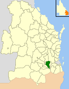
The Shire of Gatton was a local government area located in the Lockyer Valley region between the cities of Toowoomba and Ipswich, and about 90 kilometres (56 mi) west of Brisbane, the state capital of Queensland, Australia. The shire covered an area of 1,571.8 square kilometres (606.9 sq mi), and existed from 1880 until its merger with the Shire of Laidley to form the Lockyer Valley Region on 15 March 2008.
History
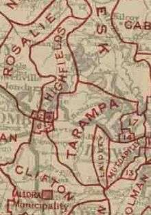
Tarampa Division was created on 15 January 1880 under the Divisional Boards Act 1879, and its board held its first meeting on 20 February 1880. On 25 April 1888, the Laidley Division area broke away and separately incorporated, and on 25 January 1890, the Forest Hill area moved from Tarampa Division to Laidley Division.[2]
With the passage of the Local Authorities Act 1902, Tarampa Division became the Shire of Tarampa on 31 March 1903.
On 3 September 1938, the Shire of Tarampa was renamed the Shire of Gatton.[3] On 19 March 1949 it grew to incorporate part of the former Shires of Drayton and Highfields, while losing some of its original area to the City of Toowoomba and Shire of Crows Nest.[4]
On 15 March 2008, under the Local Government (Reform Implementation) Act 2007 passed by the Parliament of Queensland on 10 August 2007, the Shire of Gatton merged with the Shire of Laidley to form the Lockyer Valley Region.
Structure
The Shire of Gatton was divided into three divisions electing a total of eight councillors, plus a popularly elected mayor.
- Division One (4 councillors)—eastern area, including Gatton.
- Division Two (2 councillors)—central area, including Grantham and Helidon.
- Division Three (2 councillors)—western area, including Withcott.
Towns and localities
The Shire of Gatton included the following settlements:
Population
| Year | Population |
|---|---|
| 1933 | 6,053 |
| 1947 | 6,403 |
| 1954 | 7,137 |
| 1961 | 7,594 |
| 1966 | 7,814 |
| 1971 | 8,099 |
| 1976 | 8,689 |
| 1981 | 9,675 |
| 1986 | 11,734 |
| 1991 | 13,810 |
| 1996 | 14,730 |
| 2001 | 14,925 |
| 2006 | 15,572 |
Mayors
- Bernie Sutton (1993–2000)
- Ray Ferdinand (2000-2001)
- Jim McDonald (2002–2004)
- Steve Jones (2004–2008)
References
- ↑ Australian Bureau of Statistics (25 October 2007). "Gatton (S) (Local Government Area)". 2006 Census QuickStats. Retrieved 2008-03-18.
- ↑ Queensland Government Gazette, 25 April 1888, p.1403.
- ↑ "Order in Council". Queensland Government Gazette. 3 September 1938. p. 151:794.
- ↑ Queensland Government Gazette. 17 March 1949. p. 172:981–985. Missing or empty
|title=(help)
Further reading
- Bennett, Helen; Queensland. Environmental Protection Agency (1999), Gatton Shire thematic historical overview, Queensland Environmental Protection Agency, retrieved 23 November 2017
External links
- University of Queensland: Queensland Places: Gatton Shire
- "Gatton Shire Council". Archived from the original on 29 January 2008.
Further reading
- Tew, A.M. (1979). History of Gatton Shire in the Lockyer Valley. Gatton Shire Council. ISBN 0-9595122-0-9. (111 pages)
Coordinates: 27°33′31.55″S 152°16′32.62″E / 27.5587639°S 152.2757278°E