Shire of Kolan
| Shire of Kolan Queensland | |||||||||||||||
|---|---|---|---|---|---|---|---|---|---|---|---|---|---|---|---|
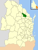 Location within Queensland | |||||||||||||||
| Population | 4,563 (2006 census)[1] | ||||||||||||||
| • Density | 1.72150/km2 (4.4587/sq mi) | ||||||||||||||
| Established | 1879 | ||||||||||||||
| Area | 2,650.6 km2 (1,023.4 sq mi) | ||||||||||||||
| Council seat | Gin Gin | ||||||||||||||
| Region | Wide Bay–Burnett | ||||||||||||||
|
| |||||||||||||||
| Website | Shire of Kolan | ||||||||||||||
| |||||||||||||||
The Shire of Kolan was a local government area located in the Wide Bay–Burnett region of Queensland, Australia, to the west of Bundaberg. The Shire, administered from the town of Gin Gin, covered an area of 2,650.6 square kilometres (1,023.4 sq mi), and existed as a local government entity from 1879 until 2008, when it was amalgamated with the City of Bundaberg and the Shires of Burnett and Isis to form the Bundaberg Region.
The major industries in the area include cattle and sugar cane.
History
Kolan Division was created on 11 November 1879 as one of the original 74 divisions around Queensland under the Divisional Boards Act 1879 with a population of 1171.[2]
On 28 January 1886, the region north of the Burnett River was excised from Kolan Division to create a separate Gooburrum Division.[3][4][5]
With the passage of the Local Authorities Act 1902, Kolan Division became the Shire of Kolan on 31 March 1903.
On 15 March 2008, under the Local Government (Reform Implementation) Act 2007 passed by the Parliament of Queensland on 10 August 2007, the Shire of Kolan merged with the Shires of Burnett and Isis and the City of Bundaberg to form the Bundaberg Region.[6]
Towns and localities
The Shire of Kolan included the following settlements:
Chairmen
- 1927: C. M. English [7]
Population
| Year | Population |
|---|---|
| 1933 | 2,941 |
| 1947 | 2,502 |
| 1954 | 2,502 |
| 1961 | 2,657 |
| 1966 | 2,614 |
| 1971 | 2,673 |
| 1976 | 2,684 |
| 1981 | 2,358 |
| 1986 | 2,649 |
| 1991 | 3,018 |
| 1996 | 4,196 |
| 2001 | 4,534 |
| 2006 | 4,638 |
External links
References
- ↑ Australian Bureau of Statistics (25 October 2007). "Kolan (S) (Local Government Area)". 2006 Census QuickStats. Retrieved 14 June 2011.
- ↑ "Proclamation [Kolan Division]". Queensland Government Gazette. 11 November 1879. p. 25:1002.
- ↑ "Proclamation [Gooburrum Division constituted]". Queensland Government Gazette. 30 January 1886. p. 38:389.
- ↑ "Proclamation [Kolan Division amended]". Queensland Government Gazette. 30 January 1886. p. 38:389.
- ↑ "Agency ID903, Gooburrum Divisional Board". Queensland State Archives. Retrieved 21 September 2013.
- ↑ "Agency ID11037, Bundaberg Region Council". Queensland State Archives. Retrieved 25 September 2013.
- ↑ Pugh, Theophilus Parsons (1927). Pugh's Almanac for 1927. Retrieved 13 June 2014.
Coordinates: 24°59′30.8″S 151°57′19.5″E / 24.991889°S 151.955417°E