Shire of Taroom
| Shire of Taroom Queensland | |||||||||||||||
|---|---|---|---|---|---|---|---|---|---|---|---|---|---|---|---|
 Location within Queensland | |||||||||||||||
| Population | 2,389 (2006 census)[1] | ||||||||||||||
| • Density | 0.128134/km2 (0.33187/sq mi) | ||||||||||||||
| Established | 1879 | ||||||||||||||
| Area | 18,644.5 km2 (7,198.7 sq mi) | ||||||||||||||
| Council seat | Taroom | ||||||||||||||
| Region | Darling Downs | ||||||||||||||
|
| |||||||||||||||
| Website | Shire of Taroom | ||||||||||||||
| |||||||||||||||
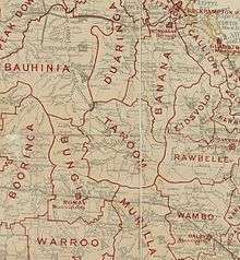
The Shire of Taroom was a local government area in the Darling Downs region of Queensland, Australia, along the Leichhardt Highway to the north of Miles. The shire covered an area of 18,644.5 square kilometres (7,198.7 sq mi), and existed as a local government area from 1879 until 2008, when it was dissolved and split between the new Western Downs Region and the Shire of Banana.
The shire contained several national parks with eroded sandstone areas, as well as Isla Gorge.
History
Taroom Division was created on 11 November 1879 as one of 74 divisions around Queensland under the Divisional Boards Act 1879 with a population of 1015.[2]
With the passage of the Local Authorities Act 1902, Taroom Division became the Shire of Taroom on 31 March 1903.

The Taroom War Memorial commemorates residents of Taroom Shire who served in World War I, World War II and the Vietnam War. It is located at the Ludwig Leichhardt Park in Yaldwyn Street and was dedicated in about 1973.[3][4]

The Taroom Shire Council Chambers were located at 18 Yaldwyn Street, now used as the Taroom administration office of the Banana Shire Council.

The Taroom Town Hall was built in 2004, immediately next door to the shire council chambers. It was intended to serve as a civic and recreational centre for the town and has a main auditorium that seats 300 people, a commercial kitchen, and a bar. The hall was awarded a regional commendation by the Royal Australian Institute of Architects in 2004.[5]
On 15 March 2008, under the Local Government (Reform Implementation) Act 2007 passed by the Parliament of Queensland on 10 August 2007, the Shire of Taroom was dissolved. Division 1 of the shire, centred on the town of Taroom, was merged into the Shire of Banana. The remainder of the Shire of Taroom, centred on the town of Wandoan was merged with the Town of Dalby and the shires of Chinchilla, Murilla, Tara and Wambo to create the new Dalby Region, renamed Western Downs Region on 29 June 2009.[6] In doing so, Taroom became one of the only three former shires in Queensland not to stay intact, alongside the shires of Tiaro and Beaudesert.
Towns and localities
The Shire of Taroom included the following settlements:
Division 1 (now part of the Shire of Banana):
- Taroom
- Ghinghinda
- Glenhaughton
- Gwambegwine
Division 2 (now part of the Western Downs Region):
Population
| Year | Population |
|---|---|
| 1921 | 1,675 |
| 1933 | 1,534 |
| 1947 | 1,921 |
| 1954 | 2,381 |
| 1961 | 3,250 |
| 1966 | 3,367 |
| 1971 | 3,494 |
| 1976 | 3,103 |
| 1981 | 3,237 |
| 1986 | 3,297 |
| 1991 | 3,066 |
| 1996 | 2,733 |
| 2001 | 2,664 |
| 2006 | 2,389 |
Chairmen and mayors
- 1927: John Mundell [7]
- Don Stiller 1997–2008
References
- ↑ Australian Bureau of Statistics (25 October 2007). "Taroom (S) (Local Government Area)". 2006 Census QuickStats. Retrieved 17 June 2011.
- ↑ "Proclamation [Taroom Division]". Queensland Government Gazette. 11 November 1879. p. 25:1003.
- ↑ "Taroom War Memorial". Monument Australia. Retrieved 16 May 2014.
- ↑ "Taroom War Memorial". Queensland War Memorial Register. Queensland Government. Retrieved 16 May 2014.
- ↑ "Taroom Town Hall". ThomsonAdsett (architects). Retrieved 16 May 2014.
- ↑ "Agency ID11044, Western Downs Regional Council". Queensland State Archives. Retrieved 24 September 2013.
- ↑ Pugh, Theophilus Parsons (1927). Pugh's Almanac for 1927. Retrieved 13 June 2014.
External links
- "Taroom Shire Council". Taroom Shire Council. Archived from the original on 24 December 2007. — archived official website
Coordinates: 25°38′27″S 149°47′50.5″E / 25.64083°S 149.797361°E