Shire of Murweh
| Shire of Murweh Queensland | |||||||||||||||
|---|---|---|---|---|---|---|---|---|---|---|---|---|---|---|---|
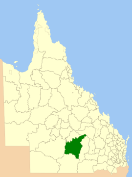 Location within of the shire in Queensland | |||||||||||||||
| Population | 4,307 (2016)[1] | ||||||||||||||
| • Density | 0.105713/km2 (0.27379/sq mi) | ||||||||||||||
| Established | 1879 | ||||||||||||||
| Area | 40,742.5 km2 (15,730.8 sq mi) | ||||||||||||||
| Mayor | Annie Liston | ||||||||||||||
| Council seat | Charleville | ||||||||||||||
| Region | South West Queensland | ||||||||||||||
| State electorate(s) | Warrego | ||||||||||||||
| Federal Division(s) | Maranoa | ||||||||||||||
|
| |||||||||||||||
| Website | Shire of Murweh | ||||||||||||||
| |||||||||||||||
The Shire of Murweh is a local government area in the Maranoa district, which is part of South West Queensland, Australia. The administrative centre and largest town in the shire is Charleville.
History
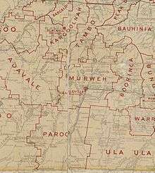
Murweh Division was created on 11 November 1879 as one of 74 divisions of Queensland under the Divisional Boards Act 1879 with a population of 1286.[2]
On 11 October 1883, there was an adjustment of boundaries between Tambo Division and Murweh Division.[3][4]
On 5 February 1889, the western part of Murweh Division was separated to create the new Adavale Division.[5][6][7]
On 21 March 1894, under the "Local Government Act 1878", Subdivision 2 of the Murweh Division was separated to create a municipality called Borough of Charleville.[8]
With the passage of the Local Authorities Act 1902, Murweh Division became the Shire of Murweh on 31 March 1903.[9]
On 10 September 1960, the Town of Charleville (the successor of the Borough of Charleville) which had been separated from Murweh Division in 1894, was absorbed back into the Shire of Murweh .[9][10]
Towns and localities
The Shire of Murweh includes the following towns and localities:
- Charleville
- Augathella
- Bakers Bend
- Boatman
- Caroline Crossing
- Clara Creek
- Cooladdi (ghost town)
- Gowrie Station
- Langlo
- Morven
- Murweh
- Nive
- Redford
- Riversleigh
- Sommariva
- Tyrconnel
- Upper Warrego
- Wallal
- Ward
- Westgate
Amenities
Murweh Shire Council operates public libraries in Augathella, Charleville and Morven.[11]
Population
| Year | Population |
|---|---|
| 1879 | 1,286 |
| 1933 | 6,141 |
| 1947 | 5,930 |
| 1954 | 7,532 |
| 1961 | 7,845 |
| 1966 | 7,483 |
| 1971 | 6,053 |
| 1976 | 5,585 |
| 1981 | 5,338 |
| 1986 | 5,287 |
| 1991 | 5,291 |
| 1996 | 4,962 |
| 2001 | 4,975 |
| 2006 | 4,580 |
| 2016 | 4,307 |
Shire Chambers
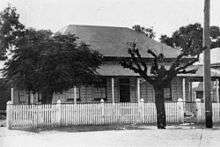
The first Murweh council chambers were built in the 1880s but were destroyed by fire in the 1930s.[12]
The new Murweh Shire Council Chambers were opened in Alfred Street in February 1938 by the shire chairman William Herbert Corbett.[12] The architects were Hall and Phillips and the contractor was T. E. Woollon of Brisbane.[13]
Chairmen and mayors
References
- ↑ Australian Bureau of Statistics (31 March 2011). "Regional Population Growth, Australia, 2009–10". Retrieved 11 June 2011.
- ↑ "Proclamation [Murweh Division]". Queensland Government Gazette. 11 November 1879. p. 25:1000.
- ↑ "Proclamation [Tambo Division amended]". Queensland Government Gazette. 13 October 1883. p. 33:1018.
- ↑ "Proclamation [Murweh Division amended]". Queensland Government Gazette. 13 October 1883. p. 33:1018-1019.
- ↑ "Proclamation [Adavale Division]". Queensland Government Gazette. 9 February 1889. p. 46:469.
- ↑ "Country News". The Queenslander. Brisbane: National Library of Australia. 2 February 1889. p. 198. Retrieved 4 September 2013.
- ↑ "Agency ID287, Adavale Divisional Board". Queensland State Archives. Retrieved 4 September 2013.
- ↑ "Agency ID2098, Charleville Municipal Council". Queensland State Archives. Retrieved 10 September 2013.
- 1 2 "Agency ID1435, Murweh Shire Council". Queensland State Archives. Retrieved 10 September 2013.
- ↑ "Agency ID560, Charleville Town Council". Queensland State Archives. Retrieved 10 September 2013.
- ↑ "Murweh Shire Council". Public Libraries Connect. State Library of Queensland. 20 September 2016. Archived from the original on 6 February 2018. Retrieved 6 February 2018.
- 1 2 3 "OFFICIAL OPENING". The Charleville Times. Brisbane: National Library of Australia. 11 February 1938. p. 7. Retrieved 10 January 2014.
- ↑ "CHARLEVILLE NOTES". Townsville Daily Bulletin. Qld.: National Library of Australia. 28 December 1937. p. 2. Retrieved 10 January 2014.
- ↑ Pugh, Theophilus Parsons (1927). Pugh's Almanac for 1927. Retrieved 13 June 2014.
- ↑ "2008 Murweh Shire - Mayoral Election - Election Summary". results.ecq.qld.gov.au. Retrieved 2017-12-04.
- ↑ "2008 Murweh Shire - Mayoral Election - Election Summary". results.ecq.qld.gov.au. Retrieved 2017-12-04.
- ↑ "2016 Murweh Shire Council - Mayoral Election - Election Summary". results.ecq.qld.gov.au. Retrieved 2017-12-04.
Coordinates: 26°24′06″S 146°14′23″E / 26.40167°S 146.23972°E