Shire of Woongarra
| Shire of Woongarra Queensland | |||||||||||||||
|---|---|---|---|---|---|---|---|---|---|---|---|---|---|---|---|
| Population | 16,491 (1991 census)[1] | ||||||||||||||
| • Density | 22.8281/km2 (59.124/sq mi) | ||||||||||||||
| Established | 1885 | ||||||||||||||
| Area | 722.4 km2 (278.9 sq mi) | ||||||||||||||
| Council seat | Bundaberg | ||||||||||||||
| Region | Wide Bay–Burnett | ||||||||||||||
| |||||||||||||||
The Shire of Woongarra was a local government area located to the south and east of the regional city of Bundaberg. The shire, administered from Bundaberg itself, covered an area of 722.4 square kilometres (278.9 sq mi), and existed as a local government entity from 1885 until 1994, when it amalgamated with Gooburrum to form the Shire of Burnett.
History
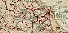
The Barolin Division was established on 11 November 1879 under the Divisional Boards Act 1879.[2] On 30 October 1885, part of Barolin Division was separated to create Woongarra Division to serve the region south of the Burnett River.[3][4][5]
With the passage of the Local Authorities Act 1902, Woongarra Division became the Shire of Woongarra on 31 March 1903,[6] while Barolin Division became the Shire of Barolin.[7]
In 1909, the Woongarra Shire had an area of 35½ square miles, with a population of 3200, with 736 ratepayers and a capital value of properties totalling £206,736. The rates collected in 1908 totalled £2378, and the loan indebtedness is £4956 9s 9d.[8]
On 21 December 1917, the Shire of Barolin was dissolved and its area was split between the City of Bundaberg and the Shire of Woongarra.[7][9]

The Shire's offices were located in 9 Barolin Street, Bundaberg.
On 21 November 1991, the Electoral and Administrative Review Commission, created two years earlier, produced its second report, and recommended that local government boundaries in the Bundaberg area be rationalised. The Local Government (Bundaberg and Burnett) Regulation 1993 was gazetted on 17 December 1993, and on 30 March 1994, the Shire of Woongarra was amalgamated with the Shire of Gooburrum to form the Shire of Burnett.
Towns and localities
Population
| Year | Population |
|---|---|
| 1921 | 2,513 |
| 1933 | 3,287 |
| 1947 | 3,345 |
| 1954 | 3,704 |
| 1961 | 4,149 |
| 1966 | 4,934 |
| 1971 | 5,150 |
| 1976 | 8,791 |
| 1981 | 9,865 |
| 1986 | 11,915 |
| 1991 | 16,491 |
Chairmen
References
- ↑ Australian Bureau of Statistics (1993). 2730.3 Census counts for small areas : Queensland. ISBN 0-642-17236-6.
- ↑ "Agency ID317, Barolin Divisional Board". Queensland State Archives. Retrieved 12 September 2013.
- ↑ "Proclamation [Woongarra Division constituted]". Queensland Government Gazette. 31 October 1885. p. 37:1507.
- ↑ "Proclamation [Barolin Division amended]". Queensland Government Gazette. 31 October 1885. p. 37:1508-1509.
- ↑ "Agency ID1950, Woongarra Divisional Board". Queensland State Archives. Retrieved 12 September 2013.
- ↑ "Agency ID1951, Woongarra Shire Council". Queensland State Archives. Retrieved 12 September 2013.
- 1 2 "Agency ID316, Barolin Shire Council". Queensland State Archives. Retrieved 12 September 2013.
- ↑ "BUNDABERG Past and PRESENT". Queensland Country Life. National Library of Australia. 1 March 1909. p. 3. Retrieved 3 February 2014.
- ↑ Queensland Government Gazette, 21 December 1917, Vol. 109, p.2029.
- 1 2 Nolan, J.G. "Cran, John (1848–1935)". Australian Dictionary of Biography. National Centre of Biography, Australian National University. Retrieved 26 December 2013.
- 1 2 3 4 5 Rackemann, Neville; Woongarra (Qld.). Council (1985), A Century of progress : Woongarra Shire, 1885–1985, Woongarra Shire Council, ISBN 978-0-9588762-0-9
- ↑ Consolidated Index to Queensland Government Gazette 1859-1919. Queensland Family History Society. 2004. ISBN 1 876613 79 3.
- ↑ Pugh, Theophilus Parsons (1927). Pugh's Almanac for 1927. Retrieved 13 June 2014.
External links
Coordinates: 24°52′13.15″S 152°20′43.8″E / 24.8703194°S 152.345500°E