Shire of Aramac
| Shire of Aramac Queensland | |||||||||||||||
|---|---|---|---|---|---|---|---|---|---|---|---|---|---|---|---|
 Location within Queensland | |||||||||||||||
| Population | 754 (2006 census)[1] | ||||||||||||||
| • Density | 0.032272/km2 (0.08358/sq mi) | ||||||||||||||
| Established | 1879 | ||||||||||||||
| Area | 23,364.1 km2 (9,020.9 sq mi) | ||||||||||||||
| Council seat | Aramac | ||||||||||||||
| Region | Central Queensland | ||||||||||||||
|
| |||||||||||||||
| |||||||||||||||
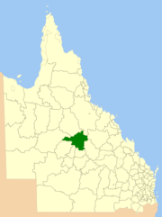
The Shire of Aramac was a local government area located in central Queensland about 1,100 kilometres (684 mi) north west of the state capital, Brisbane, between the towns of Barcaldine and Winton. It covered an area of 23,364.1 square kilometres (9,020.9 sq mi), and existed as a local government entity from 1879 until 2008, when it amalgamated with the Shires of Barcaldine and Jericho to form the Barcaldine Region.
History
The Aramac Division was created on 11 November 1879 as one of 74 divisions around Queensland under the Divisional Boards Act 1879 with a population of 841.[2]
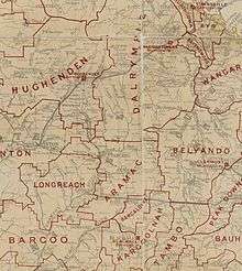
On 9 May 1900, part of the Aramac Division was excised to create the new Longreach Division under the Divisional Boards Act 1887.[3]
On 27 December 1902, part of the Aramac Division was excised to create the Ilfracombe Division under the Divisional Boards Act 1887.[4]
With the passage of the Local Authorities Act 1902, Aramac Division became the Shire of Aramac on 31 March 1903.[5]
On 15 March 2008, under the Local Government (Reform Implementation) Act 2007 passed by the Parliament of Queensland on 10 August 2007, the Shire of Aramac merged with the Shires of Barcaldine and Jericho to form the Barcaldine Region.[5][6]
The Shire operated a railway from Aramac to its junction with the railway from Rockhampton to Longreach at Barcaldine[7] from 1911 to 1975.
Towns and localities
The Shire of Aramac included the following settlements:
- Aramac
- Bangall
- Cornish Creek
- Galilee
- Ibis
- Ingberry
- Muttaburra
- Pelican Creek
- Sardine
- Tablederry
- Upland
- Upper Cornish Creek
Chairmen
- 1880: T. Whannell [8]
- 1881: J. Tilbury (resigned November 1881)[8]
- 1882: E.R. Edkins (resigned March 1882)[8]
- 1882: W. Forsyth [8]
- 1883–1884: T. Whannell [8]
- 1885: W. Forsyth [8]
- 1886–1888: E.R. Edkins [8]
- 1889–1890: S.P. Fraser [8]
- 1891: E.R. Edkins [8]
- 1892–1901: S.P. Fraser [8]
- 1902: E.R. Edkins [8]
- 1903–1905: S.P. Fraser [8]
- 1906: D.C.K. Cameron [8]
- 1907–1914: S.P. Fraser [8]
- 1915 – December 1923: E.W. Bowyer [8]
- 1924–1936: Sydney Harold Fraser [8][9]
- 1936–1939: B. Duke [8]
- 1939–1946: Sydney Harold Fraser [8]
- 1946–1955: R.A. Stobo [8]
- 1955–1976: J.T. Neill [8]
- 1976–1982: O.N. Landers [8]
- 1986: Antonio Monte de Ramos Jr [10]
Population
| Year | Population |
|---|---|
| 1933 | 1,679 |
| 1947 | 1,592 |
| 1954 | 1,714 |
| 1961 | 1,790 |
| 1966 | 1,652 |
| 1971 | 1,168 |
| 1976 | 1,059 |
| 1981 | 1,082 |
| 1986 | 1,097 |
| 1991 | 832 |
| 1996 | 778 |
| 2001 | 742 |
| 2006 | 754 |
References
- ↑ Australian Bureau of Statistics (25 October 2007). "Aramac (S) (Local Government Area)". 2006 Census QuickStats. Retrieved 17 September 2009.
- ↑ "Proclamation [Aramac Division]". Queensland Government Gazette. 11 November 1879. p. 25:1005.
- ↑ "Agency ID11204, Longreach Divisional Board". Queensland State Archives. Retrieved 21 September 2013.
- ↑ "WESTERN DIVISIONAL BOARDS". The Morning Bulletin. Rockhampton, Qld. 2 January 1903. p. 5. Retrieved 21 September 2013 – via National Library of Australia.
- 1 2 "Agency ID296, Aramac Shire Council". Queensland State Archives. Retrieved 21 September 2013.
- ↑ "Agency ID11031, Barcaldine Regional Council". Queensland State Archives. Retrieved 21 September 2013.
- ↑ The Aramac Tramway Preston, R & Tonkies, R. Australian Railway Historical Society Bulletin, August 1957 pp118-123
- 1 2 3 4 5 6 7 8 9 10 11 12 13 14 15 16 17 18 19 20 21 Smith, Anne; James Cook University of North Queensland. Department of History and Politics (1994). This El Dorado of Australia : a centennial history of Aramac Shire. Dept. of History and Politics, James Cook University. pp. 428–433. ISBN 978-0-86443-520-0.
- ↑ Pugh, Theophilus Parsons (1927). Pugh's Almanac for 1927. Retrieved 13 June 2014.
- ↑ Pugh, Theophilus Parsons (1927). Pugh's Almanac for 1927. Retrieved 13 June 2014.
External links
- "Aramac Shire". Queensland Places. Centre for the Government of Queensland, University of Queensland.