Shire of Fitzroy
| Shire of Fitzroy Queensland | |||||||||||||||
|---|---|---|---|---|---|---|---|---|---|---|---|---|---|---|---|
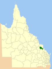 Location within Queensland | |||||||||||||||
| Population | 10,310 (2006 census)[1] | ||||||||||||||
| • Density | 1.7478/km2 (4.5269/sq mi) | ||||||||||||||
| Established | 1899 | ||||||||||||||
| Area | 5,898.7 km2 (2,277.5 sq mi) | ||||||||||||||
| Council seat | Gracemere | ||||||||||||||
| Region | Capricornia | ||||||||||||||
|
| |||||||||||||||
| Website | Shire of Fitzroy | ||||||||||||||
| |||||||||||||||
The Shire of Fitzroy was a local government area located in the Capricornia region of Central Queensland, Queensland, Australia, to the immediate west and south of the regional city of Rockhampton. The shire, administered from the town of Gracemere, covered an area of 5,898.7 square kilometres (2,277.5 sq mi), and existed as a local government entity from 1899 until 2008, when it amalgamated with several other councils to become the Rockhampton Region. It is named for the Fitzroy River, that passes along the northern boundary of the shire.
History
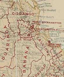
On 11 November 1879, the Gogango Division was established as one of 74 divisions around Queensland under the Divisional Boards Act 1879.[2] On 6 April 1899, the section of Gogango south of the Fitzroy River split away to form the Fitzroy Division.[3]
With the passage of the Local Authorities Act 1902, Fitzroy Division became the Shire of Fitzroy on 31 March 1903.[3][4]
On 15 March 2008, under the Local Government (Reform Implementation) Act 2007 passed by the Parliament of Queensland on 10 August 2007, the Shire of Fitzroy merged with the City of Rockhampton and the Shires of Mount Morgan and Livingstone to form the Rockhampton Region.[4][5]
At the time of amalgamation, the Shire of Fitzroy was the only local government area in Queensland without a library service.[6]
Towns and localities
The Shire of Fitzroy included the following settlements:
Chairmen
- 1927: J. W. O'Shanesy [7]
Population
| Year | Population |
|---|---|
| 1933 | 4,256 |
| 1947 | 3,773 |
| 1954 | 3,554 |
| 1961 | 3,576 |
| 1966 | 3,590 |
| 1971 | 3,434 |
| 1976 | 3,441 |
| 1981 | 4,645 |
| 1986 | 6,406 |
| 1991 | 8,047 |
| 1996 | 9,499 |
| 2001 | 9,553 |
| 2006 | 10,310 |
References
- ↑ Australian Bureau of Statistics (25 October 2007). "Fitzroy (S) (Local Government Area)". 2006 Census QuickStats. Retrieved 2008-03-18.
- ↑ "Agency ID896, Gogango Divisional Board". Queensland State Archives. Retrieved 20 September 2013.
- 1 2 "Agency ID243, Fitzroy Divisional Board". Queensland State Archives. Retrieved 20 September 2013.
- 1 2 "Agency ID245, Fitzroy Shire Council". Queensland State Archives. Retrieved 20 September 2013.
- ↑ "Agency ID11047, Rockhampton Regional Council". Queensland State Archives. Retrieved 20 September 2013.
- ↑ "Story time joy as new Gracemere library opens". Rockhampton Morning Bulletin. 27 August 2017. Archived from the original on 1 February 2018. Retrieved 1 February 2018.
- ↑ Pugh, Theophilus Parsons (1927). Pugh's Almanac for 1927. Retrieved 13 June 2014.
External links
Coordinates: 23°26′12.16″S 150°27′21.26″E / 23.4367111°S 150.4559056°E