Gogango
| Gogango Queensland | |||||||||||||||
|---|---|---|---|---|---|---|---|---|---|---|---|---|---|---|---|
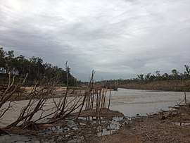 Fitzroy River near Gogango | |||||||||||||||
 Gogango | |||||||||||||||
| Coordinates | 23°40′00″S 150°02′32″E / 23.6666°S 150.0422°ECoordinates: 23°40′00″S 150°02′32″E / 23.6666°S 150.0422°E | ||||||||||||||
| Population | 310 (2011 census)[1] | ||||||||||||||
| • Density | 0.357/km2 (0.925/sq mi) | ||||||||||||||
| Postcode(s) | 4702 | ||||||||||||||
| Area | 867.9 km2 (335.1 sq mi) | ||||||||||||||
| Time zone | AEST (UTC+10) | ||||||||||||||
| Location |
| ||||||||||||||
| LGA(s) | Rockhampton Region | ||||||||||||||
| State electorate(s) | Mirani | ||||||||||||||
| Federal Division(s) | Flynn | ||||||||||||||
| |||||||||||||||
Gogango is a small town and a locality in the Rockhampton Region, Queensland, Australia.[2][3] At the 2011 census, Gogango and the surrounding area had a population of 310.[1]
Geography
Gogango is in Central Queensland. The Capricorn Highway traverses the south of the locality passing through the town. The Central Western railway line also traverses the south of the locality mostly parallel and to the immediate north of the highway.[4] The town is serviced by the Gogango railway station.[5]
The Fitzroy River flows from west to east through the centre of the locality. Gogango Creek flows from south to north through the town and is a tributary of the Fitzroy River.[4]
The principal land use is farming, mostly grazing cattle.[6]
History
Goganjo Provisional School opened in 1874 but closed circa 1878. In 1888 it renamed under the name Gogango Provisional School (note change of spelling) becoming Gogango State School on 1 January 1909.[7]
On 29 November 1950, the Gogango hall held an Ambulance Ball. People from Westwood, Mt Morgan and Rockhampton attended.
In the 2010-11 Queensland floods the Fitzroy River which passes through the area of Gogango rose to 28 meters. Gogango Creek also flooded, stopping traffic on the Capricorn Highway. The Capricorn highway was also flooded for more than 12 hours in January 2013. In February 2015, Cyclone Marcia caused heavy rainfall which led to Gogango creek rising over the highway.
Infrastructure
The site for the proposed Rookwood weir is located on the Fitzroy River in the Gogango area, about 15 km from the township. When completed the $72 million weir will hold over 100 thousand megalitres. The Weir will be built over 2 stages, The first stage will be 17 metres high and the second stage will be 0.5 metre, With a complete height of 17.5 meters, inundating 1,930 hectares.[8]
Education
Gogango State School is a primary (P-6) school for boys and girls operated by the Queensland Government at 10 Wills Street. In 2016, the school had an enrolment of 9 students with 3 teachers (1 full-time equivalent) and 4 non-teaching staff (2 full-time equivalent).[6]
A bus travels out from Rockhampton to transport high school students back to South Rockhampton High School.
Facilities
Gogango has one public park, it is located at the corner of Third Street and Wills Street.
References
- 1 2 Australian Bureau of Statistics (31 October 2012). "Gogango (State Suburb)". 2011 Census QuickStats. Retrieved 19 November 2014.

- ↑ "Gogango - town in Rockhampton Region (entry 14122)". Queensland Place Names. Queensland Government. Retrieved 8 November 2017.
- ↑ "Gogango - locality in Rockhampton Region (entry 48657)". Queensland Place Names. Queensland Government. Retrieved 8 November 2017.
- 1 2 "Queensland Globe". State of Queensland. Retrieved 15 November 2017.
- ↑ "Gogango - railway station in the Rockhampton Region (entry 14123)". Queensland Place Names. Queensland Government. Retrieved 15 November 2017.
- 1 2 "2016 Annual Report" (PDF). Gogango State School. Archived (PDF) from the original on 15 November 2017. Retrieved 15 November 2017.
- ↑ Queensland Family History Society (2010), Queensland schools past and present (Version 1.01 ed.), Queensland Family History Society, ISBN 978-1-921171-26-0
- ↑ "Statewide Water Policy: Quarterly Project Progress Report: February 2009" (PDF). Queensland Government. Archived (PDF) from the original on 16 November 2017. Retrieved 16 November 2017.