Gilgit River
| Gilgit River | |
|---|---|
 | |
| Native name | دریائے گلگت |
| Country | Pakistan Administrated Kashmir |
| Autonomous Territory | Gilgit-Baltistan |
| Districts | Gilgit District, Ghizer District |
| Physical characteristics | |
| River mouth | 35°44′31″N 74°37′29″E / 35.74194°N 74.62472°ECoordinates: 35°44′31″N 74°37′29″E / 35.74194°N 74.62472°E |
| Length | 240 km |
| Basin features | |
| Waterbodies | Shandur Lake, Phander Lake, Attabad Lake |
The Gilgit River (Urdu: دریائے گلگت) is a tributary of the Indus River, and flows past the town of Gilgit. It is located in the Gilgit–Baltistan, the northmost political entity of Pakistan. The Gilgit River starts from Shandur Lake,[1] joins the Indus River at junction point of three mountains ranges near town of Juglot.[2][3] It is also referred to as the Ghizer River.
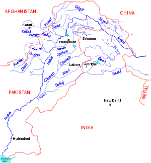
The Gilgit River is a tributary of the Indus River
See also
References
- ↑ isbn:1483603792 - Cerca con Google (in Italian).
- ↑ Handy, Norman (2017). K2, The Savage Mountain: Travels in Northern Pakistan. novum pro Verlag. ISBN 9783990487174.
- ↑ Dani, Ahmad Hasan; Masson, Vadim Mikhaĭlovich (2003). History of Civilizations of Central Asia: Development in contrast : from the sixteenth to the mid-nineteenth century. UNESCO. ISBN 9789231038761.
| Wikimedia Commons has media related to Gilgit River. |
This article is issued from
Wikipedia.
The text is licensed under Creative Commons - Attribution - Sharealike.
Additional terms may apply for the media files.