Sind River
| Sind River | |
| River | |
 Sind River | |
| Country | India |
|---|---|
| State | Jammu and Kashmir |
| Region | Kashmir Valley |
| District | Ganderbal |
| Source | 34°12′14.860″N 75°35′21.94″E / 34.20412778°N 75.5894278°ECoordinates: 34°12′14.860″N 75°35′21.94″E / 34.20412778°N 75.5894278°E |
| - location | Machoi Glacier |
| - elevation | 4,800 m (15,748 ft) |
| Mouth | 34°11′2.382″N 74°40′36.21″E / 34.18399500°N 74.6767250°E |
| - location | Jehlum river at Shadipora |
| - elevation | 1,600 m (5,249 ft) |
| Length | 108 km (67 mi) |
| Discharge | |
| - average | 290 m3/s (10,241 cu ft/s) |
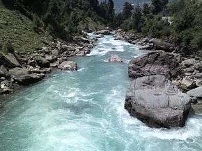
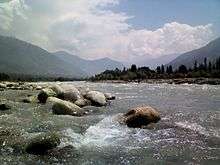
The Sind River or the Sindh River is a river in the Ganderbal district of Jammu and Kashmir state of India. It is a major tributary of the Jehlum River and is 108 kilometres long.
Geography
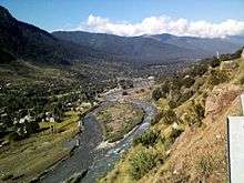
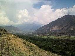
The Sind River forms the Sind Valley. The source of the river lies in Machoi Glacier at an elevation of 4800 metres, east of Amarnath temple south of Zojila pass.[1][2] It flows through Panjtarni (a camping site of Amarnath yatra) southwards up to Domail where it joins a tributary which doubles its flow from Kolhoi Glacier. It flows mostly westwards along with NH 1D and is fed by many glacial streams on its way to Ganderbal town. At Kichpora Preng it is fed by Wangath river which flows down from the Gangabal Lake. The major tributaries of the river are:
- Amarnath stream,
- Kolhoi Grar
- Shitkadi Nallah,
- Gund Nallah,
- Surfraw Nallah and
- Wangath Nallah
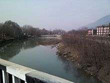
surfraw Nallah is Big Nallah which joins The Sindh at Surfraw(Soraf raw).This Nallah is also known for Beauty and Fish.[3] It is navigable from Ganderbal town onwards as the waterflow slows down. It joins the Jehlum River at Shadipora.[4] 17 kilometres northwest from Srinagar city. The Sind River passes through a famous alpine hill station Sonamarg where river rafting[5] tournaments on the river are being organised yearly by the Tourism Department of Jammu and Kashmir.[6] It is the only river in Jammu and Kashmir on which three hydroelectric power plants are functional. The waters of the river are used for irrigation by way of different canals[7] and for domestic use after going through water treatment plants.
Fish
The Sind River is the natural habitat of trout, and other various types of fishes. The most famous among them are:[8]
- Brown trout[9] (Salmo trutta)
- Rainbow trout (Oncorynchus mykiss)
- Snow trout (Schizothorax plagiostomus)
- Shuddgurn
- Anyour
Ecological issues
Trout and hence trout fishing are at risk along the Sind.h
- The extraction of sand/bajri by engagement of heavy machines is destroying the natural habitat of trout and other fish.[10]
- Wastes from dwellings and camps of security forces on the banks of the river, use of pesticides, DDT and insecticides by farmers kills many fish every day.
- The change in topography leads to destruction of aquatic fauna of Sind.
- In various riverine villages people catch fish through conventional way of angling and using nets. These methods are replaced today by resorting to unconventional and illegal methods. The worst method is using bleaching powder, procured from officials of PHE department. Bleaching powder not only kills fish but other aquatic life as well. This process is very common during summers, especially in Wayil[11] catchment area. The Fisheries Department and other government agencies do not have a high profile intervening.
- Mismanagement of water diversion to power canals is another concern for the survival of fish.[12]
Major projects on the Sind
- Upper Sind Hydroelectric Power project 1st Sumbal.[13]
- Upper Sind Hydroelectric Power Project 2nd Kangan.[14]
- Lower Sind Hydroelectric Power project Ganderbal.
- Rangil water treatment plant.[15]
Major bridges
See also
References
- ↑ Lulu. Explore Kashmiri Pandits. Lulu.com. p. 37–. ISBN 9780963479860. Retrieved 11 October 2013.
- ↑ Kalhana (2001). Kalhana's Rajatarangini: A Chronicle of the Kings of Kasmi. Elibron.com, 2001. p. 12–. ISBN 9781402173486. Retrieved 11 October 2013.
- ↑ "Upper Sindht II, Water Resources Projects in Indus Basin". nih.ernet.in. Archived from the original on 10 July 2015.
- ↑ "Shadipora". wikiedit.org.
- ↑ "Sonamarg, two died in river rafting". hindustantimes.com. Retrieved 2012-04-19.
- ↑ "Sonamarg, Kashmir-Travel and tourist guide". sonamarg.org.
- ↑ "Geography of Jammu and Kashmir State". ikashmir.net.
- ↑ "Gippsland Aquaculture Industry Network-Gain". growfish.com.au. Archived from the original on 20 February 2012. Retrieved 22 February 2012.
- ↑ Petr, ed. by T. (1999). Fish and fisheries at higher altitudes : Asia. Rome: FAO. p. 72. ISBN 92-5-104309-4.
- ↑ "sand extraction, human waste destroy trout habitat". greaterkashmir.com. Retrieved 2011-04-26.
- ↑ "Wayil India page". fallingrain.com.
- ↑ "Jammu Kashmir Holidays". jammukashmirholidays.com.
- ↑ "Upper Sindh partially resumes generation". greaterkashmir.com. Retrieved 2010-04-27.
- ↑ "Upper Sindh Project still not working". greaterkashmir.com. Retrieved 2009-09-15.
- ↑ "Rangil Water Treatment Plan to operate soon". kashmirnow.com. Retrieved 2008-09-18.