Swat River
| Swat سوات | |
| River | |
 | |
| Country | Pakistan |
|---|---|
| province | Khyber Pakhtunkhwa |
| District | Swat |
| Tributaries | |
| - left | Ushu Khwar, Bashigram Khwar |
| - right | Daral Khwar, Gabral Khwar |
| Source | Hindu Kush Mountains |
| Source confluence | Ushu khwar & Gabral Khwar |
| - location | Kalam |
| Mouth | Kabul River |
| - location | Charsadda |
| Length | 240 km (149 mi) |
| Basin | 14,000 km2 (5,405 sq mi) |
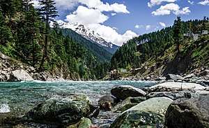
The Swat River (Urdu: دریائے سوات, Pashto: سوات سیند) is a perennial river in the northern region of Khyber-Pakhtunkhwa Province, Pakistan. The river commences in Swat Kohistan region of Kalam with the confluence of two main tributaries Ushu and Gabral and runs downstream in a narrow gorge up to Baghdheri.
Etymology
The name Swat is derived from an old Sanskrit term, Suvastu ("clear azure water"). This name of the river is attested in the Rigveda.[1]
Route
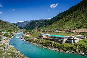
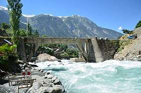
Its source lies in the Hindukush Mountains, from where it is fed by the glacial waters throughout the year and flows through the Kalam Valley in a narrow gorge with a rushing speed up to Madyan and lower plain areas of Swat Valley up to Chakdara for 160 km. In the extreme south of the valley, the river enters to a narrow gorge and joins the Panjkora River, at Qalangi, and finally empties into Kabul River, near Charsadda. It is diverted near Batkhela for irrigation and power generation purposes.
The Upper Swat Canal flows under Malakand through Benton Tunnel. Below Dargai, the upper canal is divided into two branches, supplying Charsadda and Swabi & Mardan. The water also used for hydropower generation at Jabban and Dargai Power Stations.
Economic significance
Swat River plays an important role in the economy of the valley. It irrigates large areas of Swat District, Malakand District and lower Peshawar Valley and recharge water wells & springs through seepage. The river serves as a habitat for diverse species of birds & contributes to the fishing industry of the region. The aesthetic scenery of river attracts thousands of tourists from all over Pakistan during the summer season.
Hydropower Potential
River Swat has a great untapped hydropower potential which could be harnessed for green power generation. Among them, the feasible site near Munda Headworks has an installed generation capacity of 740 MW.[2] while others are Asrit Kedam HPP, Gabral HPP and Matiltan HPP.
There are several micro hydro-electric power projects on canals from the Swat River which generate electricity for local usage.
See also
References
- Book: Hidden Treasures of Swat, ISBN 978-969-23042-0-7
- ↑ Susan Whitfield (2018). Silk, Slaves, and Stupas: Material Culture of the Silk Road. University of California Press. p. 136. ISBN 978-0-520-95766-4.
- ↑ http://wapda.gov.pk/vision2025/htmls_vision2025/munda.htm
External links
| Wikimedia Commons has media related to Swat River. |
Coordinates: 34°07′N 71°43′E / 34.117°N 71.717°E
| Authority control |
|---|