Shaw–Howard University station
Shaw – Howard University | ||||||||||||||||
|---|---|---|---|---|---|---|---|---|---|---|---|---|---|---|---|---|
|
| ||||||||||||||||
 | ||||||||||||||||
| Location |
1701 8th Street NW Washington, D.C. 20001 | |||||||||||||||
| Owned by | WMATA | |||||||||||||||
| Line(s) |
| |||||||||||||||
| Platforms | 1 island platform | |||||||||||||||
| Tracks | 2 | |||||||||||||||
| Connections |
| |||||||||||||||
| Construction | ||||||||||||||||
| Structure type | Underground | |||||||||||||||
| Bicycle facilities | 6 racks | |||||||||||||||
| Disabled access | Yes | |||||||||||||||
| Other information | ||||||||||||||||
| Station code | E02 | |||||||||||||||
| History | ||||||||||||||||
| Opened | May 11, 1991 | |||||||||||||||
| Previous names | Shaw | |||||||||||||||
| Traffic | ||||||||||||||||
| Passengers (2017) |
4,188 daily [1] | |||||||||||||||
| Services | ||||||||||||||||
| ||||||||||||||||
Shaw–Howard University is a Washington Metro station in Washington, D.C., on the Green Line. It is also served by the Yellow Line during off-peak times. The station primarily serves the Shaw neighborhood of Washington, which also contains Howard University.
Location
Shaw–Howard University station is located within the neighborhood of the same name in the Northwest quadrant of the city, specifically on 7th Street between R and S Streets. It lies just outside the defined boundaries of the Shaw Historic District, which encompasses much the area to the southwest.[2]
Transit-oriented development
Like other stations along the stretch of the Green and Yellow Lines between Gallery Place and Fort Totten, Shaw has been revitalized by transit-oriented development, increasing economic development, residential density, and—controversially—accelerating the pace of gentrification.
Among other projects, Progression Place and CityMarket at O catalyzed development in the area in the early 2010s. The former occupies previously vacant land on the same block as the northern entrance to the station and contains 115,000 sq ft (10,700 m2) of office space (with the UNCF being the anchor tenant),[3] 205 apartments labelled as "7th Flats,"[4] and 19,000 sq ft (1,800 m2) of retail.[5]
CityMarket at O, located between 7th, 9th, O, and P Streets NW, renovated the long-neglected O Street Market and added 87,000 sq ft (8,100 m2) of retail and 629 residential units.[6]
History
Part of the original Metro plan, the station was initially referred to simply as "Shaw." It opened on May 11, 1991, as part of a northward extension of the Green Line from Gallery Place–Chinatown to U Street. The central route under 7th Street, below which the station sits, was only added in 1967 primarily to serve the "inner city."[7] Instead of opening in 1976, the first Green Line stations opened in 1991.[8] While a cut-and-fill tunnel for the Green Line was built under 7th Street and U Street, both street traffic and pedestrian access on those streets were difficult.[9] The result was the loss of the traditional retail businesses along the route. The downtown segment of the line was originally projected to open in September 1977.[10]
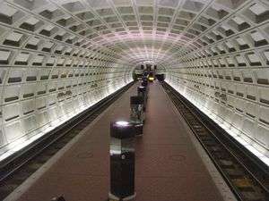
Station layout
Like most underground Metro stations, Shaw–Howard University station lies directly below street level, in this case underneath 7th Street. There are two entrances, one to the north at the corner of 7th and S Streets and the other to the south on R Street between 7th and 8th Streets.
| G | Street level | Exit/entrance |
| M | Mezzanine | One-way faregates, ticket machines, station agent |
| P Platform level |
Southbound | ← ← |
| Island platform, doors will open on the left | ||
| Northbound | → → | |
References
- ↑ "Metrorail Average Weekday Passenger Boardings" (PDF). WMATA. Retrieved August 29, 2018.
- ↑ Shaw heritage trail Archived July 23, 2008, at the Wayback Machine. Shaw Main Streets Retrieved February 13, 2011
- ↑ UNCF Headquarters Project DC Government Retrieved February 13, 2011
- ↑ 7th Flats at Progression Place Progressive Place Retrieved February 13, 2011
- ↑ The Shops at Progression Place Progression Place Retrieved February 13, 2011
- ↑ CityMarket at O CityMarket at O Retrieved February 13, 2011
- ↑ Schrag at p. 112.
- ↑ Schrag at p. 213
- ↑ Schrag at p. 217.
- ↑ Schrag at p. 214.
External links
![]()
- WMATA: Shaw–Howard Univ Station
- StationMasters Online: Shaw–Howard Univ
- The Schumin Web Transit Center: Shaw–Howard Univ Station
- S Street entrance from Google Maps Street View
- R Street entrance from Google Maps Street View
Coordinates: 38°54′47″N 77°01′20″W / 38.912919°N 77.022194°W