Georgia Avenue–Petworth station
Georgia Avenue–Petworth | ||||||||||||||||
|---|---|---|---|---|---|---|---|---|---|---|---|---|---|---|---|---|
|
| ||||||||||||||||
 | ||||||||||||||||
| Location |
3700 Georgia Avenue NW Washington, DC 20009 | |||||||||||||||
| Owned by | WMATA | |||||||||||||||
| Line(s) |
| |||||||||||||||
| Platforms | 1 island platform | |||||||||||||||
| Tracks | 2 | |||||||||||||||
| Connections |
| |||||||||||||||
| Construction | ||||||||||||||||
| Structure type | Underground | |||||||||||||||
| Bicycle facilities | 12 lockers | |||||||||||||||
| Disabled access | Yes | |||||||||||||||
| Other information | ||||||||||||||||
| Station code | E05 | |||||||||||||||
| History | ||||||||||||||||
| Opened | September 18, 1999 | |||||||||||||||
| Traffic | ||||||||||||||||
| Passengers (2017) |
5,708 daily [1] | |||||||||||||||
| Services | ||||||||||||||||
| ||||||||||||||||
Georgia Avenue–Petworth is a Washington Metro station in Washington, D.C., on the Green Line and Yellow Line. It is located at the border of the neighborhoods of Petworth, Sixteenth Street Heights, and Park View in Northwest.
It opened on September 18, 1999, part of an extension of the Green Line that connected U Street and Fort Totten, allowing trains to travel between Anacostia and Greenbelt.
The station's west entrance closed on December 11, 2006, to accommodate construction of a mixed-use development. Bus stops, bike racks, and lockers were moved, and the entrance remained closed until 2009, a year later than planned.[2]
Like many other Metro stations, Georgia Avenue-Petworth has catalyzed nearby development. The District of Columbia Office of Planning has divided development proposals near the station into four localities:
- Park View. Composed of three blocks along Georgia Avenue south of the station — 3200 West, 3400 East, and 3500 East — Park View development is mainly limited by a 50-foot (15 m) height limit to infill residential or four- to six-story mixed-use development.[3]:34–35,43
- Pleasant Plains. Further south, sites at 2700 West and 2900 West on Georgia Avenue are also subject to the low height restriction but with more emphasis on apartments and row houses.[3]:36–37,44
- Petworth-Metro. To the north, this is the largest neighborhood by sites available and height, with a restriction of 65 ft (20 m). It contains a series of blocks on Georgia Avenue from Princeton Place to Shepherd Street, with the 3700 West block already developed as Park Place, containing 148 condos and 17,000 sq ft (1,579 m2) of street-level retail space.[3]:32–33,41–42
- Upshur. The northernmost of the four regions, it is centered on Upshur Street near Kansas Avenue. As with Pleasant Plains, the Planning Office has focused on residential development for Upshur.[3]:30–31,40
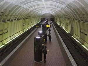
Station layout
| G | Street level | Exit/entrance |
| M | Mezzanine | One-way faregates, ticket machines, station agent |
| P Platform level |
Southbound | ← ← |
| Island platform, doors will open on the left | ||
| Northbound | → → | |
References
- ↑ "Metrorail Average Weekday Passenger Boardings" (PDF). WMATA. Retrieved July 31, 2018.
- ↑ "Georgia Ave-Petworth rail station west entrance to close for construction" (Press release). WMATA. December 7, 2006. Retrieved December 25, 2006.
- 1 2 3 4 "Georgia Avenue–Petworth Metro Station Area and Corridor Plan" (PDF). DC Office of Planning. Retrieved March 27, 2018.
External links
- WMATA: Georgia Ave-Petworth Station
- StationMasters Online: Georgia Ave-Petworth
- The Schumin Web Transit Center: Georgia Ave-Petworth Station
- Georgia Avenue and New Hampshire Avenue entrance from Google Maps Street View
- West side of Georgia Avenue entrance from Google Maps Street View
Coordinates: 38°56′10″N 77°01′28″W / 38.936112°N 77.024395°W