Gallery Place station
Gallery Place | |||||||||||||||||||||||||
|---|---|---|---|---|---|---|---|---|---|---|---|---|---|---|---|---|---|---|---|---|---|---|---|---|---|
|
| |||||||||||||||||||||||||
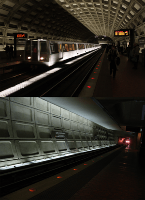 The upper and lower platforms of the Gallery Place Metro Station complex. Green/Yellow line trains share the lower level island platform, while Red Line trains serve the side platformed upper level. | |||||||||||||||||||||||||
| Location |
630 H Street, NW Washington, DC 20001 | ||||||||||||||||||||||||
| Owned by | WMATA | ||||||||||||||||||||||||
| Line(s) |
| ||||||||||||||||||||||||
| Platforms |
2 side platforms (upper level) 1 island platform (lower level) | ||||||||||||||||||||||||
| Tracks | 4 (2 per level) | ||||||||||||||||||||||||
| Connections |
| ||||||||||||||||||||||||
| Construction | |||||||||||||||||||||||||
| Structure type | Underground | ||||||||||||||||||||||||
| Depth |
43 feet (13 m) Upper Level 63 feet (19 m) Lower Level | ||||||||||||||||||||||||
| Platform levels | 2 | ||||||||||||||||||||||||
| Disabled access | Yes | ||||||||||||||||||||||||
| Other information | |||||||||||||||||||||||||
| Station code |
B01 (upper level) F01 (lower level) | ||||||||||||||||||||||||
| History | |||||||||||||||||||||||||
| Opened | December 15, 1976 | ||||||||||||||||||||||||
| Previous names |
Gallery Place (1976-1986) Gallery Place–Chinatown (1986-2011) | ||||||||||||||||||||||||
| Traffic | |||||||||||||||||||||||||
| Passengers (2017) |
22,427 daily [1] | ||||||||||||||||||||||||
| Services | |||||||||||||||||||||||||
| |||||||||||||||||||||||||
Gallery Place is a Washington Metro station in Washington, D.C., United States, on the Green, Red and Yellow Lines. It is a transfer station between the Red Line on the upper level and the Green/Yellow Lines on the lower level.
Location
Gallery Place is located in Northwest Washington, with entrances at 7th and F, 7th and H, and 9th and G Streets. The station's only street elevator is north of F Street on the east side of 7th Street.
The station, which is beneath the Capital One Arena, serves that arena and the surrounding Chinatown and Penn Quarter neighborhoods in downtown Washington. The station is located very close to Metro Center, such that the lights of one are visible down the tunnel from the other.
Notable places nearby
- Calvary Baptist Church
- Capital One Arena (home of the Washington Wizards, Washington Capitals, Washington Mystics, Washington Valor, and Georgetown Hoyas)
- Ford's Theater and Petersen House (also known as the House Where Lincoln Died)
- The German-American Heritage Museum of the USA
- International Spy Museum
- J. Edgar Hoover Building (headquarters of the Federal Bureau of Investigation)
- Martin Luther King Jr. Memorial Library (main branch of the District of Columbia Public Library)
- National Academy of Sciences
- National Building Museum
- National Law Enforcement Officers Memorial
- Old Patent Office Building (houses both the National Portrait Gallery and the Smithsonian American Art Museum)
- Washington Convention Center
- Woolly Mammoth Theatre Company
History
Service began on December 15, 1976, as part of the original Red Line that ran from Farragut North to Rhode Island Avenue–Brentwood. The opening of the station was delayed by a court order over lack of handicapped access (it was originally supposed to open with the rest of the first stations on March 27, 1976). WMATA provided assurance that such access would be available by June 1, 1977.
Yellow Line service began on April 30, 1983, extending service to the Pentagon and National Airport stations. An abstract wall sculpture, The Yellow Line by Constance Fleures, was installed in 1989 on the lower level platform,[2] Green Line service began in 1991, adding service (at the time) to U Street and Anacostia.
Originally named "Gallery Place" after the nearby National Portrait Gallery and Smithsonian American Art Museum, "Chinatown" was added to the station name in 1986 (although the station's signage was not replaced until 1990). In 2000, a sculpture entitled The Glory of the Chinese Descendants by Foon Sham, was installed over the 7th and H Street entrance at the mezzanine level. The sculpture depicts a large Chinese-style fan above a bowl of rice.[3] The station reverted to its original name, "Gallery Place", on November 3, 2011, with "Chinatown" listed as a subtitle.[4]
This station has been a testing ground for new features in Metro stations. In 1993, the station was one of the first Metro stations to receive tactile edging on its platforms. Since 2004, the station has been the site of testing for new signage. As a result, there is far more signage in this station than most others, including lighted signs, as well as signage that isn't found anywhere else in the system. In 2007, red LEDs were tested for the platform edge lights on the upper level. Orange LEDs were tested at the platform edge on the lower level, before being replaced by red LEDs in 2008. In 2017, WMATA added yellow stickers on the platform floors to remind riders where the end of six-car trains stop, to help riders avoid being in the area near the end of the platform behind where the last car of the train stops.[5]
Station layout
| G | Street Level | Exit/ Entrance |
| B1 | Mezzanine | One-way faregates, ticket machines, station agent |
| B2 Red Line platforms |
Side platform, doors will open on the right | |
| Westbound | ← | |
| Eastbound | → | |
| Side platform, doors will open on the right | ||
| B3 Green/Yellow Line platforms |
Southbound | ← ← |
| Island platform, doors will open on the left | ||
| Northbound | → → | |
Like other downtown transfer stations, Gallery Place has a two-level configuration. However, unlike Metro Center and L'Enfant Plaza, where the platforms cross centrally, the Green and Yellow Line platforms are located near the east end of the station, resulting in an off-balance layout. This is a result of the Green and Yellow Lines' location below 7th Street NW, while the Red Line must bend towards the southeast in order to reach Judiciary Square and Union Station.[6]
Plans to add a pedestrian tunnel connecting Gallery Place with Metro Center have long been in the works. The "Gallery Place/Chinatown - Metro Center Pedestrian Passageway Tunnel Study" was completed in July 2005.[7]
Gallery
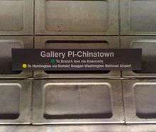 Station signage for Green/Yellow Lines platform
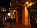 Entrance to the Gallery Place Metro station, along 7th Street at Capital One Arena.
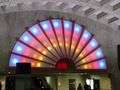 The Glory of the Chinese Descendants at the Chinatown exit
 The Yellow Line on the lower level platform
References
- ↑ "Metrorail Average Weekday Passenger Boardings" (PDF). WMATA. Washington Metropolitan Area Transit Authority. Retrieved July 31, 2018.
- ↑ Washington Metropolitan Area Transit Authority (WMATA). "Gallery Place-Chinatown Station: The Yellow Line, 1989." Art by Metro Line. Accessed March 9, 2013.
- ↑ WMATA. "Gallery Place-Chinatown Station: The Glory of the Chinese Descendants, 2000." Art by Metro Line. Accessed March 9, 2013.
- ↑ WMATA. "Station names updated for new map" (Press release). November 3, 2011. Archived from the original on November 5, 2011. Retrieved November 5, 2011.
- ↑ "Metro's Answer To Station Crowding: Better Signs". WAMU. 2017-10-27. Retrieved 2018-06-15.
- ↑ WMATA. "Emergency Evacuation Map: Gallery Pl-Chinatown Station; 7th & H Sts Exit." Accessed March 9, 2013.
- ↑ Parsons; KPG Design Studio; Basile Baumann Prost; Associates (July 2005). "Gallery Place/Chinatown - Metro Center Pedestrian Passageway Tunnel Study" (PDF). WMATA Office of Planning and Project Development. Retrieved March 6, 2009.
External links
| Wikimedia Commons has media related to Gallery Place (WMATA station). |
- WMATA: Gallery Pl-Chinatown
- StationMasters Online: Gallery Pl-Chinatown Station
- The Schumin Web Transit Center: Gallery Place Station (Upper Level)
- The Schumin Web Transit Center: Gallery Place Station (Lower Level)
- G Street and 9th Street entrance from Google Maps Street View
- F Street and 7th Street entrance from Google Maps Street View
- H Street and 7th Street entrance from Google Maps Street View
Coordinates: 38°53′56″N 77°01′18″W / 38.89889°N 77.02167°W