Forest Glen station
Forest Glen | |||||||||||
|---|---|---|---|---|---|---|---|---|---|---|---|
|
| |||||||||||
 | |||||||||||
| Location |
9730 Georgia Avenue Forest Glen, MD 20910 | ||||||||||
| Coordinates | 39°00′55″N 77°02′35″W / 39.0153°N 77.0430°WCoordinates: 39°00′55″N 77°02′35″W / 39.0153°N 77.0430°W | ||||||||||
| Owned by | WMATA | ||||||||||
| Line(s) |
| ||||||||||
| Platforms | twin tube inter-connected side platforms | ||||||||||
| Tracks | 2 | ||||||||||
| Connections |
| ||||||||||
| Construction | |||||||||||
| Structure type | Underground | ||||||||||
| Depth | 196 feet (60 m) | ||||||||||
| Parking | 592 spaces[1] | ||||||||||
| Bicycle facilities | 42 racks, 16 lockers | ||||||||||
| Disabled access | Yes | ||||||||||
| Other information | |||||||||||
| Station code | B09 | ||||||||||
| History | |||||||||||
| Opened | September 22, 1990[2] | ||||||||||
| Traffic | |||||||||||
| Passengers (2017) |
2,126 daily [3] | ||||||||||
| Services | |||||||||||
| |||||||||||
Forest Glen station is a side platformed Washington Metro station in Forest Glen, Maryland, United States. The station was opened on September 22, 1990, and is operated by the Washington Metropolitan Area Transit Authority (WMATA).[1][4] Its opening coincided with the completion of 3.2 miles (5.1 km) of rail north of the Silver Spring station and the opening of the Wheaton station.[1][4][5] Providing service for the Red Line, the station is located at Georgia Avenue (Maryland Route 97) and Forest Glen Road. The station is the deepest in the system at 196 feet (60 m) deep, so high-speed elevators, rather than escalators, are used for access to the surface.[1]
Station layout
Due to tracks resting at a depth of 196 feet (60 m), Forest Glen is the only station in the system without direct surface access by way of escalators.[4] Instead, there is a bank of six high-speed elevators that travel at a rate of 17 feet per second (5.2 m/s) between the underground station and the surface.[6] In addition, a 20-story staircase exists for emergency use. Because of the lack of escalators, Forest Glen is the only station equipped with smoke doors to protect customers during a train fire and evacuation.[4] Building the tunnels through soft rock close to the surface would have been either very costly or impossible, so engineers decided to dig the tunnels through harder, more solid rock deeper in the ground.[1][7]
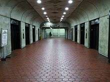
Another architectural feature of this station is separate tunnels and platforms for each direction, instead of the large, vaulted common room seen at most other underground stations.[8] This design, shared with Wheaton, was used because it was cheaper than building a larger two-tracked station with a larger base and higher vaulted ceilings.[4][8]
| G | Street Level | Exit/ Entrance |
| M | Mezzanine | One-way faregates, ticket machines, station agent |
| P Platform level |
Westbound | ← |
| Side platform, doors will open on the left | ||
| Side platform, doors will open on the left | ||
| Eastbound | → | |
History
The original plan was to build the station above ground, with a parking lot that would have required demolishing about fifteen homes.[9] After community opposition to the above-ground station, Montgomery County approved a modified plan for an underground station.[9]
The originally planned location for the parking lot and bus stops was on the east side of Georgia Avenue, between Sherwood Road and Tilton Drive, near Woodland Drive.[7] Tilton Drive would have been closed between Georgia Avenue and Woodland Drive in order to reduce traffic through the nearby residential neighborhood.[7] Building the parking lot and bus stops there would have required the demolition of one business and several homes.[7]
Response to plans for the underground station were mixed, with some residents and local businesses looking forward to the convenience of a nearby station and other residents concerned about potential increases in traffic in the area.[1][9] Metro contended that deleting the station from the plans altogether would have overloaded both Wheaton and Silver Spring metro stations.[7] The Montgomery County council approved the station in January 1976,[9] three months after it had approved the further-away Wheaton station.[10]
References
- 1 2 3 4 5 6 Fehr, Stephen C. (September 16, 1990). "Wheaton, Forest Glen To Climb Aboard Metro: New Stations to Extend Red Line 3.2 Miles". The Washington Post. p. D1 – via ProQuest. (Subscription required (help)). Article preview
- ↑ Hill, Retha (September 18, 1990). "Metro Station Divides Forest Glen Residents: Impact on Century-Old Community an Issue". The Washington Post. p. D07. (Subscription required (help)). Article Preview
- ↑ "Metrorail Average Weekday Passenger Boardings" (PDF). WMATA. May 2016. Retrieved July 31, 2018.
- 1 2 3 4 5 Fehr, Stephen C. (September 23, 1990). "Metro Adds 2 Stations To System; Wheaton, Forest Glen Open for Thousands". The Washington Post. p. D4.
- ↑ "Sequence of Metrorail openings" (PDF). WMATA. 2017. p. 3. Retrieved April 1, 2018.
- ↑ Levy, Claudia (November 6, 1989). "New Metro Stop Is Way Down Under: Curious in Md. Take Preview Plunge Into Area's Deepest Station". The Washington Post. p. B03 – via ProQuest. (Subscription required (help)). Article preview Article blurb
- 1 2 3 4 5 Eisen, Jack (April 14, 1975). "Public Hearings Set On Metro Stop Shift In Montgomery County". The Washington Post. p. C3 – via ProQuest. (Subscription required (help)).
- 1 2 Burgess, John (November 4, 1981). "Jumbo Bores Metro Tunnel: Transit Agency Racing Against Reagan Funds Slash". The Washington Post. p. C1 – via ProQuest. (Subscription required (help)). Article preview
- 1 2 3 4 "County Approves Forest Glen Stop". The Washington Post. January 14, 1976. p. B2 – via ProQuest. Article preview
- ↑ "County Council Decides On Wheaton Metro Site". The Washington Post. October 8, 1975. p. A9 – via ProQuest. Article preview
External links
![]()
- WMATA: Forest Glen Station
- StationMasters Online: Forest Glen Station (The map incorrectly shows the station as having 8 rather than 6 elevators.)
- Forest Glen Road entrance from Google Maps Street View