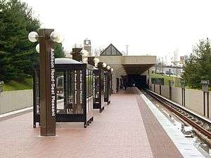
Addison Road station
Addison RoadSeat Pleasant | |||||||||||||||
|---|---|---|---|---|---|---|---|---|---|---|---|---|---|---|---|
|
| |||||||||||||||
 | |||||||||||||||
| Location |
100 Addison Road South Capitol Heights, MD 20743 | ||||||||||||||
| Coordinates | 38°53′12.2″N 76°53′39.4″W / 38.886722°N 76.894278°W | ||||||||||||||
| Owned by | Washington Metropolitan Area Transit Authority | ||||||||||||||
| Line(s) |
| ||||||||||||||
| Platforms | 1 island platform | ||||||||||||||
| Tracks | 2 | ||||||||||||||
| Connections |
| ||||||||||||||
| Construction | |||||||||||||||
| Parking | 1,268 spaces | ||||||||||||||
| Bicycle facilities | 16 racks | ||||||||||||||
| Disabled access | Yes | ||||||||||||||
| Other information | |||||||||||||||
| Station code | G03 | ||||||||||||||
| History | |||||||||||||||
| Opened | November 22, 1980 | ||||||||||||||
| Previous names |
Addison Road (1980–2000) Addison Road–Seat Pleasant (2000–2011) | ||||||||||||||
| Traffic | |||||||||||||||
| Passengers (2017) |
2,899 daily [1] | ||||||||||||||
| Services | |||||||||||||||
| |||||||||||||||
Addison Road (also known as Addison Road–Seat Pleasant) is an island platformed Washington Metro station in Walker Mill, Maryland, United States. The station was opened on November 22, 1980, and is operated by the Washington Metropolitan Area Transit Authority (WMATA). Providing service for the Blue and Silver Lines, the station is located near the residential area of Seat Pleasant on Central Avenue near Addison Road. In December 2012, Addison Road was one of five stations added to the route of the Silver Line, which was originally supposed to end at the Stadium-Armory station, but was extended into Prince George's County, Maryland to the Largo Town Center station (the eastern terminus of the Blue Line) due to safety concerns about a pocket track just past Stadium-Armory.[2] Silver Line service at Addison Road began on July 26, 2014.[3]
The station opened on November 22, 1980, and coincided with the completion of 3.52 miles (5.66 km) of rail east of the Stadium–Armory station and the opening of the Benning Road and Capitol Heights stations.[4] Originally named "Addison Road"; "Seat Pleasant" was added in 2000,[5] and moved to a new subtitle location in 2011.[6] It was the eastern terminus of the Blue Line from its opening until December 18, 2004, when the extension to the Largo Town Center station opened to the east.[7]
In December 2003, security cameras at this station filmed a deer walking around the station mezzanine, running down an escalator, and going down the platform past a waiting train, as startled passengers watched. The deer then jumped onto the tracks and escaped into nearby woods. Metro spokesperson Lisa Farbstein reported that Metro had nicknamed the deer "Rudolph the Blue Line Reindeer".[8]
Station layout
| G | Street level | Exit/entrance |
| M | Mezzanine | One-way faregates, ticket machines, station agent |
| P Platform level |
Westbound | ← ← |
| Island platform, doors will open on the left | ||
| Eastbound | → | |
References
- ↑ "Metrorail Average Weekday Passenger Boardings" (PDF). WMATA. Retrieved August 28, 2018.
- ↑ Aratani, Lori (December 5, 2012). "Metro details Silver Line service changes". The Washington Post. Retrieved July 8, 2016.
- ↑ Halsey, Ashley (July 26, 2014). "All aboard! Metro's new Silver Line rolls down the tracks for the first time". The Washington Post. Retrieved July 8, 2016.
- ↑ Cooke, Janet (November 23, 1980), "Three new Metro stations have a festive first day", The Washington Post, p. D1
- ↑ Staff Reporters (March 24, 2000). "Metro to rename 4 subway stations". The Washington Post.
- ↑ "Station names updated for new map" (Press release). Washington Metropolitan Area Transit Authority. November 3, 2011. Archived from the original on November 5, 2011. Retrieved November 5, 2011.
- ↑ Dana, Rebecca (December 19, 2004). "Metro, Prince George's extend their reach; Two new Blue Line stations open, bringing passengers and economic potential". The Washington Post. p. C3.
- ↑ "Deer runs through rail station". December 17, 2003. Retrieved April 27, 2007.
External links
![]()
- WMATA: Addison Road–Seat Pleasant Station
- StationMasters Online: Addison Road–Seat Pleasant Station
- The Schumin Web Transit Center: Addison Road–Seat Pleasant Station
- Central Avenue entrance from Google Maps Street View