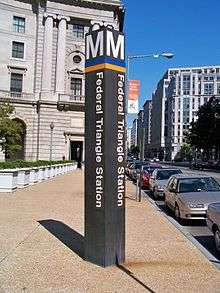
Federal Triangle station
Federal Triangle | |||||||||||||||||||||
|---|---|---|---|---|---|---|---|---|---|---|---|---|---|---|---|---|---|---|---|---|---|
|
| |||||||||||||||||||||
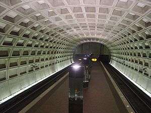 Station platform in January 2004 | |||||||||||||||||||||
| Location |
302 12th Street, Northwest Washington, D.C. 20004 | ||||||||||||||||||||
| Owned by | Washington Metropolitan Area Transit Authority | ||||||||||||||||||||
| Line(s) |
| ||||||||||||||||||||
| Platforms | 1 island platform | ||||||||||||||||||||
| Tracks | 2 | ||||||||||||||||||||
| Connections |
| ||||||||||||||||||||
| Construction | |||||||||||||||||||||
| Structure type | Underground | ||||||||||||||||||||
| Bicycle facilities | 20 racks | ||||||||||||||||||||
| Disabled access | Yes | ||||||||||||||||||||
| Other information | |||||||||||||||||||||
| Station code | D01 | ||||||||||||||||||||
| History | |||||||||||||||||||||
| Opened | July 1, 1977 | ||||||||||||||||||||
| Traffic | |||||||||||||||||||||
| Passengers (2017) |
7,555 daily [1] | ||||||||||||||||||||
| Services | |||||||||||||||||||||
| |||||||||||||||||||||
Federal Triangle is an island platformed Washington Metro station in Downtown Washington, D.C., United States. The station was opened on July 1, 1977, and is operated by the Washington Metropolitan Area Transit Authority (WMATA). Providing service for the Blue, Orange, and Silver Lines, the station's entrance is beneath the William Jefferson Clinton Federal Building. On January 13, 1982, an eastbound Metro train on the Orange Line derailed just east of the station resulting in three fatalities, the first fatalities in the system's history.[2]
The station opened on July 1, 1977.[3] Its opening coincided with the completion of 11.8 miles (19.0 km)[4] of rail between National Airport and RFK Stadium and the opening of the Arlington Cemetery, Capitol South, Crystal City, Eastern Market, Farragut West, Federal Center SW, Foggy Bottom–GWU, L'Enfant Plaza, McPherson Square, National Airport, Pentagon, Pentagon City, Potomac Avenue, Rosslyn, Smithsonian and Stadium–Armory stations.[5] Orange Line service to the station began upon the line's opening on November 20, 1978.[6] Silver Line service at Federal Triangle began on July 26, 2014.[7]
Location
The station serves an area of Washington crowded with federal buildings, on 12th Street between Pennsylvania Avenue NW and Constitution Avenue NW, including the triangular area formed by 15th Street, Constitution, and Pennsylvania known as Federal Triangle, from which the station takes its name. The triangle includes such federal buildings as the Robert F. Kennedy Department of Justice Building, the Herbert C. Hoover Building (Department of Commerce), and the buildings of the Internal Revenue Service and the Environmental Protection Agency.
Station layout
Federal Triangle utilizes the simple island platform layout. There are two tracks: track D1 is used for trains bound for New Carrollton and Largo Town Center, and track D2 is used for trains going to Vienna, Wiehle - Reston East and Franconia-Springfield.[8] As with all stations on the Metro, there are platform edge lights to warn passengers of incoming trains. In 2008, WMATA installed red-colored LED lights at Federal Triangle and centrally-located stations after a successful pilot at Gallery Place-Chinatown.[9] There is a coffered barrel-vault ceiling at Federal Triangle, as is typical of other Washington Metro stations built at that time.
There is only one entrance to the platform level, located slightly south of the center of the platform.[10] Escalators from this mezzanine level lead to the plaza of the William Jefferson Clinton Federal Building. A flat square on the ceiling of the station denotes a possible second entrance to the station; this has yet to be used. Similar walls can be found at stations such as Archives-Navy Memorial-Penn Quarter.
| G | Street level | Exit/entrance |
| M | Mezzanine | One-way faregates, ticket machines, station agent |
| P Platform level |
Westbound | ← ← ← |
| Island platform, doors will open on the left | ||
| Eastbound | → → | |
Notable places nearby
- Several federal government buildings in and near the Federal Triangle
- Robert F. Kennedy Department of Justice Building (Department of Justice headquarters):
- Herbert C. Hoover Building (Department of Commerce headquarters)
- Environmental Protection Agency
- J. Edgar Hoover Building (Federal Bureau of Investigation headquarters)
- Old Post Office (Trump International Hotel)
- Ronald Reagan Building and International Trade Center
- Freedom Plaza
- Pershing Park
- National Mall
- Several Smithsonian Institution museums on the Mall, including the National Museum of American History and National Museum of Natural History
References
- ↑ "Metrorail Average Weekday Passenger Boardings" (PDF). WMATA. May 2017. Retrieved February 17, 2018.
- ↑ Stephen J. Lynton (January 14, 1982). "Metro Train Derails; 3 Die".
- ↑ Feaver, Douglas B. (July 1, 1977), "Today, Metro could be U.S. model", The Washington Post, p. A1
- ↑ "Sequence of Metrorail openings" (PDF). WMATA. 2017. p. 3. Retrieved March 30, 2018.
- ↑ "Metro's newest stations: Where they are, what's nearby", The Washington Post, June 24, 1977
- ↑ Eisen, Jack; John Feinstein (November 18, 1978), "City-County fanfare opens Orange Line; Ceremonies open new Orange Line", The Washington Post, p. D1
- ↑ Halsey, Ashley (July 26, 2014). "All aboard! Metro's new Silver Line rolls down the tracks for the first time". The Washington Post. Retrieved July 8, 2016.
- ↑ "John R Cambron track maps". Retrieved September 11, 2008.
- ↑ "Metro installing more red platform edge lights" (Press release). WMATA. Retrieved March 30, 2018.
- ↑ "Blue line". NYCSubway. Retrieved September 11, 2008.
External links
| Wikimedia Commons has media related to Federal Triangle (WMATA station). |
- WMATA: Federal Triangle station
- StationMasters Online: Federal Triangle Station
- The Schumin Web Transit Center: Federal Triangle Station
- 12th Street entrance from Google Maps Street View
Coordinates: 38°53′38″N 77°01′43″W / 38.893814°N 77.028515°W