Fort Totten station
Fort Totten | |||||||||||||||||||||
|---|---|---|---|---|---|---|---|---|---|---|---|---|---|---|---|---|---|---|---|---|---|
|
| |||||||||||||||||||||
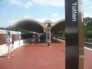 Red line platform | |||||||||||||||||||||
| Location |
550 Galloway Street, NE Washington, DC 20011 | ||||||||||||||||||||
| Coordinates | 38°57′06″N 77°00′08″W / 38.951777°N 77.002174°WCoordinates: 38°57′06″N 77°00′08″W / 38.951777°N 77.002174°W | ||||||||||||||||||||
| Owned by | WMATA | ||||||||||||||||||||
| Line(s) |
| ||||||||||||||||||||
| Platforms | 2 island platforms (1 per level) | ||||||||||||||||||||
| Tracks | 4 (2 per level) | ||||||||||||||||||||
| Connections |
| ||||||||||||||||||||
| Construction | |||||||||||||||||||||
| Structure type |
Elevated Red Line Underground Green Line and Yellow Line | ||||||||||||||||||||
| Platform levels | 2 | ||||||||||||||||||||
| Parking | 408 spaces | ||||||||||||||||||||
| Bicycle facilities | 10 racks, 6 lockers | ||||||||||||||||||||
| Disabled access | Yes | ||||||||||||||||||||
| Other information | |||||||||||||||||||||
| Station code |
B06 (upper level) E06 (lower level) | ||||||||||||||||||||
| History | |||||||||||||||||||||
| Opened | February 6, 1978 | ||||||||||||||||||||
| Traffic | |||||||||||||||||||||
| Passengers (2017) |
8,030 daily [1] | ||||||||||||||||||||
| Services | |||||||||||||||||||||
| |||||||||||||||||||||
Fort Totten is a Washington Metro station in northeastern Washington, D.C. It acts as a transfer point between the Green and Red Lines with Yellow Line service during off-peak hours. It is the last station on the Green Line in the District of Columbia before heading into Maryland. It is triply unique in being a 3-story station, the entrance and exit are on the second floor between the two lines, and both lines are island platforms.
Location
Fort Totten is located in the middle of Fort Totten Park in Northeast and is accessed via Galloway Street. The station is considered to be in the neighborhood of Fort Totten, and is a short distance from the neighborhoods of Manor Park and Riggs Park.[2] The station's name comes from a Civil War-era fortification which itself was named after General Joseph Gilbert Totten, the Chief Engineer of the antebellum US Army.
History
_in_2006.jpg)
Service began on the Red Line (upper) platform on February 6, 1978, and on the Green Line (lower) platform on December 11, 1993.[3] Between 1993 and September 1999, Fort Totten served as the terminus of the northern portion of the Green Line until the opening of stations between Fort Totten and U Street-Cardozo. Beginning on December 31, 2006 as part of an 18-month trial, Metro extended Yellow Line service to Fort Totten station during non-rush hours and weekends.[4] In a press release, Councilmember Jim Graham said that the service change would support the "development and urban lifestyle" of the neighborhoods between the Fort Totten and Mount Vernon Square stations.[5] As a part of the Metro Rush Plus initiative, which began in June 2012 and ended in June 2017, several Yellow Line trains arriving from Franconia–Springfield continued onto Greenbelt and vice versa, thus bringing full-time Yellow Line service between Fort Totten and Mount Vernon Square.[6]
2009 Red Line collision
On June 22, 2009, two southbound Metro trains on the Red Line collided between the Takoma and Fort Totten stations, killing 9 and injuring 80, the deadliest accident in the system's history.[7] A plaque inside the station's mezzanine commemorates the victims of the crash. Plans are in the works to one day create a memorial site outside the station after the current accommodations were deemed insensitive by the victims' families. [8]
Station layout
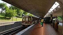
The lower-level platform for the Green Line (and the Yellow Line during off-peak times) is unique in that it is built into a hillside, part underground in a rock tunnel, and part at ground level in an open cut. A single-track connection east of the station allows trains to be moved between the Red and Green Lines, and was once used for the Green Line Commuter Shortcut service to Farragut North via the Red Line tracks, before the mid-city segment of the Green Line was completed in September 1999.
| 1F | Westbound | ← |
| Island platform, doors will open on the left | ||
| Eastbound | → | |
| M | Street level | Exit/Entrance, one-way faregates, ticket machines, station agent |
| B1 | Southbound | ← ← |
| Island platform, doors will open on the left | ||
| Northbound | → → | |
References
- ↑ "Metrorail Average Weekday Passenger Boardings" (PDF). WMATA. Washington Metropolitan Area Transit Authority. Retrieved July 31, 2018.
- ↑ "Station Vicinity Map: Fort Totten" (PDF). WMATA. Retrieved April 1, 2018.
- ↑ "Sequence of Metrorail openings" (PDF). WMATA. 2017. p. 3. Retrieved April 1, 2018.
- ↑ Weiss, Eric M. (December 30, 2006). "Yellow Line Is En Route to Fort Totten". The Washington Post. p. B01.
- ↑ "Metro Extends Yellow Line to Fort Totten During Off-Peak Hours" (Press release). WMATA. December 26, 2006.
- ↑ "Metro unveils new system map in preparation for Rush Plus" (Press release). WMATA. March 19, 2012. Retrieved April 1, 2018.
- ↑ Sun, Lena H.; Glod, Maria (June 23, 2009). "At Least 6 Killed in Red Line Crash; THE IMPACT: Train Strikes Another, Injuring Scores, Stalling Commute". The Washington Post. Retrieved June 23, 2009.
- ↑ Weir, Kyjta (June 22, 2012). "Gray to unveil Fort Totten Metro crash memorial plaque but no park decision". The Washington Examiner. Retrieved July 17, 2012.
External links
![]()
- WMATA: Fort Totten Station
- StationMasters Online: Fort Totten Station
- The Schumin Web Transit Center: Fort Totten Station (Upper Level)
- The Schumin Web Transit Center: Fort Totten Station (Lower Level)
- Galloway Street entrance from Google Maps Street View