Tenleytown–AU station
Tenleytown – AU | |||||||||||
|---|---|---|---|---|---|---|---|---|---|---|---|
|
| |||||||||||
 | |||||||||||
| Location |
4501 Wisconsin Avenue, NW Washington, DC 20016 | ||||||||||
| Coordinates | 38°56′53.1″N 77°4′45.9″W / 38.948083°N 77.079417°WCoordinates: 38°56′53.1″N 77°4′45.9″W / 38.948083°N 77.079417°W | ||||||||||
| Owned by | WMATA | ||||||||||
| Line(s) |
| ||||||||||
| Platforms | 1 island platform | ||||||||||
| Tracks | 2 | ||||||||||
| Connections |
| ||||||||||
| Construction | |||||||||||
| Structure type | Underground | ||||||||||
| Depth | 162 feet (49 m) | ||||||||||
| Parking | 17 spaces (parking meters) | ||||||||||
| Bicycle facilities | 20 racks, 20 lockers | ||||||||||
| Disabled access | Yes | ||||||||||
| Other information | |||||||||||
| Station code | A07 | ||||||||||
| History | |||||||||||
| Opened | August 25, 1984 | ||||||||||
| Previous names |
Tenley Circle Tenleytown | ||||||||||
| Traffic | |||||||||||
| Passengers (2017) |
5,357 daily [1] | ||||||||||
| Services | |||||||||||
| |||||||||||
Tenleytown–AU is a rapid transit station on the Red Line of the Washington Metro in Washington, D.C. Located in the Upper Northwest neighborhood, it is the last station on the Red Line heading outbound wholly within the District of Columbia; the next stop, Friendship Heights, lies within both the District and the state of Maryland.
Location
The southernmost station underneath the Wisconsin Avenue NW corridor, Tenleytown–AU station lies within the neighborhood of the same name in the Upper Northwest portion of the city. More specifically, it lies north of Tenley Circle, for which the area is named, below Wisconsin Avenue NW at its intersection with Albemarle Street NW. Nearby are several educational institutions, the most notable of which are: American University (AU, which is over one mile away from the station, albeit connected by a shuttle); Sidwell Friends School (famous for being the school of choice of presidential children); Woodrow Wilson High School; the high school of Georgetown Day School; and the affiliated National Cathedral School and St Albans Schools.[2] In addition, Fort Reno Park and the Washington National Cathedral are located close to the station.[2]
History
Originally to be called Tenley Circle, in February 1980 the Metro Board officially changed its name to Tenleytown.[3] The station opened on August 25, 1984.[4][5] Its opening coincided with the completion of 6.8 miles (10.9 km) of rail northwest of the Van Ness–UDC station and the opening of the Bethesda, Friendship Heights, Grosvenor and Medical Center stations.[4][5][6] In May 1989, although objected to by several community groups, the Metro Board officially changed its name to Tenleytown–AU due to its proximity to American University.[7] The $63,500 cost of changing the names on signs, pylons and maps throughout the system was paid for by the District government.[7]
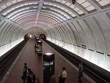
Station layout
| G | Street Level | Exit/ Entrance |
| M | Mezzanine | One-way faregates, ticket machines, station agent |
| P Platform level |
Westbound | ← |
| Island platform, doors will open on the left | ||
| Eastbound | → | |
Gallery
| Wikimedia Commons has media related to Tenleytown–AU (WMATA station). |
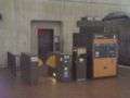 Platform-level faregate
References
- ↑ "Metrorail Average Weekday Passenger Boardings" (PDF). WMATA. May 2017. Retrieved February 11, 2018.
- 1 2 "Tenleytown–AU Station Vicinity Map" (PDF). WMATA. Retrieved February 11, 2018.
- ↑ Staff Reporters (February 15, 1980). "Metro station to be named Tenleytown". The Washington Post. p. A6.
- 1 2 Staff Reporters (August 25, 1984). "Red Line adds 6.8 miles; Opening ceremony for new segment set for today at Friendship Heights". The Washington Post. p. B1.
- 1 2 Brisbane, Arthur S. (August 26, 1984). "All aboard; Metro festivities welcome latest Red Line extension". The Washington Post. p. A1.
- ↑ "Sequence of Metrorail openings" (PDF). Washington Metropolitan Area Transit Authority. 2017. p. 3. Retrieved February 11, 2018.
- 1 2 Staff Reporters (May 12, 1989). "Metro names change". The Washington Post. p. C4.
External links
- WMATA: Tenleytown–AU Station
- StationMasters Online: Tenleytown–AU Station
- The Schumin Web Transit Center: Tenleytown–AU Station
- Albemarle Street entrance from Google Maps Street View
- West side of Wisconsin Avenue entrance from Google Maps Street View