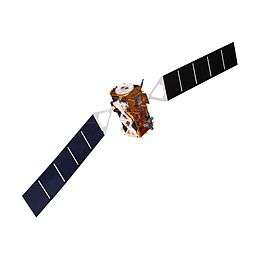
Sentinel-3
 | |||
| Manufacturer | Thales Alenia Space[1] | ||
|---|---|---|---|
| Operator | EUMETSAT | ||
| Applications | Earth observation | ||
| Specifications | |||
| Spacecraft type | Satellite | ||
| Bus | Prima | ||
| Constellation | 2 | ||
| Design life | 7 years[2] | ||
| Launch mass | 1,250 kg (2,756 lb)[2] | ||
| Dimensions | 3.710 × 2.202 × 2.207 m (12.2 × 7.2 × 7.2 ft)[2] | ||
| Power | 2,100 W[2] | ||
| Production | |||
| Status | Active | ||
| Built | 2 | ||
| On order | 4[3] | ||
| Launched | 2 | ||
| Operational | 1 | ||
| First launch |
Sentinel-3A 16 February 2016 | ||
| Last launch |
Sentinel-3D ≥ 2021[3] | ||
| |||
Sentinel-3 is an Earth observation satellite constellation developed by the European Space Agency as part of the Copernicus Programme.[4][5][6]
Copernicus, formerly Global Monitoring for Environment and Security, is the European programme to establish a European capacity for Earth observation designed to provide European policy makers and public authorities with accurate and timely information to better manage the environment, and to understand and mitigate the effects of climate change.
Overview
On 14 April 2008, the European Space Agency and Thales Alenia Space signed a €305 million contract to build the first GMES Sentinel-3 in its Cannes Mandelieu Space Center.[7] Satellite platform was delivered to France for final components assembly in 2013.[8] Communications systems were completed by Thales Alenia Space España in early 2014.[9] Sentinel-3A was subsequently launched on 16 February 2016 on a Rockot vehicle,[10] followed by Sentinel-3B on 25 April 2018, also aboard a Rockot.[11]
The Sentinel-3 mission's main objective is to measure sea-surface topography, sea- and land-surface temperature and ocean- and land-surface colour with accuracy in support of ocean forecasting systems, and for environmental and climate monitoring.[4][6][5] Sentinel-3 builds directly on the heritage pioneered by ERS-2 and Envisat satellites. Near-real time data will be provided for ocean forecasting, sea-ice charting, and maritime safety services on the state of the ocean surface, including surface temperature, marine ecosystems, water quality and pollution monitoring.[6]
A pair of Sentinel-3 satellites will enable a short revisit time of less than two days for the OLCI instrument and less than one day for SLSTR at the equator. This will be achieved using both Sentinel-3A and Sentinel-3B satellites in conjunction.[10] The satellite orbit provides a 27-day repeat for the topography package, with a 4-day sub-cycle.[6]
Objectives
- Measure sea-surface topography, sea-surface height and significant wave height
- Measure ocean and land-surface temperature
- Measure ocean and land-surface colour
- Monitor sea and land ice topography
- Sea-water quality and pollution monitoring
- Inland water monitoring, including rivers and lakes
- Aid marine weather forecasting with acquired data
- Climate monitoring and modelling
- Land-use change monitoring
- Forest cover mapping
- Fire detection
- Weather forecasting
- Measuring Earth's thermal radiation for atmospheric applications
Mission characteristics
- Role: Earth observation satellite
- Launch mass: Appx. 1,150 kg (2,540 lb)
- Orbit: Sun-synchronous
- Altitude: 814 km (506 mi)
- Inclination: 98.6°
- Local time of Descending Node: 10:00 a.m.
- Orbit cycle: ~100 minutes
- Nominal duration: 7.5 years
Instruments
Sentinel-3 will make use of multiple sensing instruments:[4][6]
- SLSTR (Sea and Land Surface Temperature Radiometer) will determine global sea-surface temperatures to an accuracy of better than 0.3 K (0.3 °C; 0.5 °F). It measures in nine spectral channels and two additional bands optimised for fire monitoring.
- OLCI (Ocean and Land Colour Instrument) is a medium-resolution imaging spectrometer that uses five cameras to provide a wide field of view. OLCI has 21 spectral bands with wavelengths ranging from the optical to the near-infrared.[12] Bands vary in width from 2.5 nm to 40 nm, and serve a variety of different purposes, including measuring water vapor absorption, aerosol levels, and chlorophyll absorption.[12] SLSTR and OLCI are optical instruments with an overlap of their swath path, allowing for new combined applications. This is currently the only sensor in space able to detect cyanobacteria.[13]
- SRAL (SAR Altimeter) is the main topographic instrument to provide accurate topography measurements over sea ice, ice sheets, rivers and lakes. It uses dual-frequency Ku and C band and is supported by a microwave radiometer for atmospheric correction and a DORIS receiver for orbit positioning.
- DORIS (Doppler Orbitography and Radiopositioning Integrated by Satellite) is a receiver for orbit positioning.
- MWR (Microwave Radiometer) will measure water vapour and cloud water content and the thermal radiation emitted by the Earth.
- LRR (Laser Retroreflector) will be used to accurately locate the satellite in orbit using a laser ranging system. When used in combination with SRAL, DORIS, MWR, they will acquire detailed topographic measurements of the ocean and in-land water.
- GNSS (Global Navigation Satellite System) will provide precise orbit determination and can track multiple satellites simultaneously.
Satellite Operation and Data Flow
Sentinel-3 is operated by the European Space Operation Centre (ESA) and Eumetsat. The in-orbit operations for Sentiental-3 are coordinated by Eumetsat in Darmstadt, Germany. This includes monitoring the health of the satellite and the instruments. Eumetsat also serves as the backup flight control center. The ESA coordinates housekeeping telemetry and commands at the ground station in Kiruna, Sweden. In addition, the ESA operates a x-band core station in Svalbard, Norway. This station is responsible for receiving the data collected by Sentinel-3.[14] The data is then analyzed by the Sentinel Collaborative Ground Segment and compiled into the Copernicus Space Component (CSC). The CSC is an earth observation program run by the ESA with the objective of providing high quality continuous monitoring of the earth.[6]
Applications
The applications of Sentinel-3 are diverse. Using the collection of sensors on-board Sentinel-3 is able to detect ocean and land temperature and color change. The Ocean land Color Instrument (OLCI) has a 300m resolution with 21 distinct bands allowing global coverage in less than four days. This sensor can then be used to by researches to do water quality and land-monitoring research.[15] The satellite also has the ability to monitor the temperature of the sea, land and ice through the Sea and Land Surface Temperature Radiometer (SLSTR). Sentinel-3 also had the ability to detect changes in sea-surface height and sea-ice using the synthetic aperture radar altimeter and the microwave radiometer, two of the most complex sensors on the satellite.[15]
The observations acquired by the mission will be used to in conjunction with other ocean-observing missions to contribute to the Global Ocean Observing System (GOOS) which aims to create a permanent system of ocean observation.[15]
- Ocean colour and land reflectance data
- Sea, land and ice surface temperature
- Active fire and burnt area monitoring
- Sea surface topography data
Gallery
Examples of images taken.
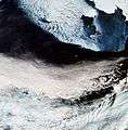 Bering Sea
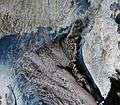 Kamchatka, Russia
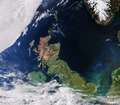 United Kingdom
References
- ↑ "Copernicus: Sentinel-3". eoPortal. European Space Agency. Retrieved 21 December 2015.
- 1 2 3 4 "Sentinel-3 Data Sheet" (PDF). European Space Agency. August 2013. Retrieved 17 November 2016.
- 1 2 Henry, Caleb (10 February 2016). "ESA Awards Sentinel 3C and D Satellite Contracts to Thales Alenia Space". Via Satellite. Retrieved 17 November 2016.
- 1 2 3 4 "Sentinel 3". European Space Agency. 2015. Retrieved 10 June 2015.
- 1 2 Donlon, C.; Berruti, B.; Buongiorno, A; Ferreira, M-H; Femenias, P.; et al. (2012). "The Global Monitoring for Environment and Security (GMES) Sentinel-3 Mission". Remote Sensing of the Environment. 120: 27–57. Bibcode:2012RSEnv.120...37D. doi:10.1016/j.rse.2011.07.024.
- 1 2 3 4 5 6 7 "Copernicus: Sentinel-3". European Space Agency. 2015. Retrieved 11 June 2015.
- ↑ "Contract signed for ESA's Sentinel-3 earth observation satellite". European Space Agency. 14 April 2008. Retrieved 17 August 2014.
- ↑ "Bringing Sentinel-3 together". European Space Agency. 6 March 2013. Retrieved 17 August 2014.
- ↑ "Thales Alenia Space España's contribution to Europe's Sentinel satellites". Thales Alenia Group. 24 April 2014. Retrieved 17 August 2014.
- 1 2 "Sentinel-3 - ESA EO Missions". Earth Online. European Space Agency. Retrieved 2018-03-13.
- ↑ Clark, Stephen (25 April 2018). "European environmental observer launched by Russian rocket". Spaceflight Now. Retrieved 25 April 2018.
- 1 2 Sentinel-3 Team. (September 2, 2013). "Sentinel-3 User Handbook". European Space Agency. Archived from the original on 2016-03-05. Retrieved March 15, 2018.
- ↑ "Copernicus: Sentinel-3 - Satellite Missions - eoPortal Directory". directory.eoportal.org. Retrieved 2018-03-13.
- ↑ esa. "Data flow". European Space Agency. Retrieved 2018-04-03.
- 1 2 3 "Sentinel-3 stacks up". European Space Agency. 24 April 2014. Retrieved 21 December 2015.
External links
| Wikimedia Commons has media related to Sentinel-3. |
- Sentinel-3 website by EUMETSAT
- Sentinel-3 website by European Space Agency
- Sentinel-3 website by eoPortal
- Sentinel-3 NRT visualisation website by OceanDataLab
| Sentinel satellites |
|  | |||||||
|---|---|---|---|---|---|---|---|---|---|
| Contributing missions |
| ||||||||
| |||||||||||||||
| |||||||||||||||
| Telecommunications |
| ||||||||||||||
Technology demonstrators | |||||||||||||||
| Cancelled and proposed | |||||||||||||||
| Failed | |||||||||||||||