COSMO-SkyMed
COSMO-SkyMed (COnstellation of small Satellites for the Mediterranean basin Observation) is an Earth observation satellite system funded by the Italian Ministry of Research and Ministry of Defence and conducted by the Italian Space Agency (ASI), intended for both military and civilian use.[1]
The space segment of the system includes four identical medium-sized satellites equipped with synthetic aperture radar (SAR) sensors with global coverage of the planet.[2] Observations of an area of interest can be repeated several times a day in all-weather conditions. The imagery will be applied to defense and security assurance in Italy and other countries, seismic hazard analysis, environmental disaster monitoring, and agricultural mapping.[3]
Space segment
The four satellites are in sun-synchronous polar orbits with a 97.9° inclination at a nominal altitude of 619 km and an orbital period of 97.2 minutes. The local time ascending node at the equator is 06:00. The expected operating life of each satellite is estimated to be 5 years. Each satellite repeats the same ground track every 16 days, and all of the satellites follow the same ground track. They cross the equator at 06:00 and 18:00 local-time each day. The satellites are phased in the same orbital plane, with COSMO-SkyMed's 1, 2 and 4 at 90° to each other and COSMO-SkyMed 3 at 67.5° from COSMO-SkyMed 2. This results in varied intervals between the satellites along the same ground track of between 1 and 15 days. The sun-synchronous orbit is used to keep the solar cells illuminated at all times.
The satellites' main components are:
- Two solar arrays for 3.8 kW at 42 V DC
- Stabilization, navigation and GPS systems
- Synthetic aperture radar working in X band
- 300 Gbit on-board memory and 310 Mbit/s data-link with ground segments
The radar antenna is a phased array that is 1.4 m wide x 5.7 m long. The system is capable of both single- and dual-polarization collection. The center frequency is 9.6 GHz with a maximum radar bandwidth of 400 MHz.[4]
Launch
United Launch Alliance is providing launch services for the first three satellites. Satellite processing for the first two satellites was handled by the Astrotech Space Operations subsidiary of SPACEHAB.[3] The first satellite was launched at 22:34 GMT, on 8 June 2007, aboard a Delta II 7420-10 rocket from Vandenberg AFB.[5] An identical rocket launched COSMO-2 at 02:31:42 GMT on 9 December 2007,[6] the launch having been delayed from 6 December due to bad weather, and problems with the rocket's cork insulation. COSMO-3 launched at 02:38 GMT on 25 October 2008, also aboard a Delta II 7420-10. A Delta II flying in the 7420-10 configuration will also be used to launch COSMO-4.[7] Launched from Vandenberg Air Force Base on November 5, 2010 at 1920L.
Ground segment
The ground segment of the system is composed of:
- Command Center:

- Tracking and data stations:
- User Ground Segments:
The Argentinian and the French governments are involved respectively in the civil and military segments of the system.
SAR capabilities
The COSMO-SkyMed satellites have three basic types of imaging modes:
- Spotlight, a high-resolution mode collected over a small area by steering the radar beam slightly fore-to-aft during the collection period.
- Stripmap, a medium-resolution mode collected over long, continuous swaths in which the beam is pointed broadside to the satellite track.
- ScanSAR, a low-resolution mode that creates extra-wide swaths by collecting short segments at different ranges and then mosaicking them together.
There are two Spotlight modes:
- SPOTLIGHT1, which is a military-only mode, and
- SPOTLIGHT2, which provides a resolution of 1 m over a 10 km x 10 km area. Spotlight polarization is limited to either HH or VV
There are two Stripmap modes:
- HIMAGE, which provides a resolution of between 3 and 5 m over a swath of 40 km, and
- PINGPONG, which collects dual-polarization data at 15 m resolution over a swath of 30 km. The dual-polarization data can consist of any two polarizations (HH, VV, VH, HV), and it is non-coherent, as it is collected in "pulse groups" that alternate from one polarization to the other.
There are two ScanSAR modes:
- WIDEREGION, which provides 30 m resolution data over a swath of 100 km, and
- HUGEREGION, which provides 100 m resolution data over a swath of 200 km.
The system is sized to collect up to 450 images per satellite per day.[8]
Commercialization
eGEOS, S.p.A. has the exclusive worldwide commercial rights to sell COSMO-SkyMed data and products.[9]
Flares
The COSMO-SkyMed satellites are lesser-known deliverers of satellite flares, sometimes approaching magnitude −3. Flares come mainly from SAR-panels of the satellites. Although overshadowed by the Iridium satellites, the flares are often long-lasting, with the satellites traversing much of the sky at brighter-than-average magnitudes.
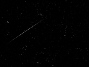 A COSMO-SkyMed flare.
See also
References
- ↑ "COSMO-SkyMed: Mission definition and main applications and products" (PDF). ESA.
- ↑ "COSMO-SkyMed". Telespazio. Archived from the original on 2007-07-08.
- 1 2 "SPACEHAB Subsidiary Signs New Contracts Totaling $4.7 Million". SPACEHAB.
- ↑ "COSMO-SkyMed User Guide" (PDF). ASI.
- ↑ "Worldwide launch schedule". Spaceflight Now. Archived from the original on 2013-09-11.
- ↑ NASA Spaceflight.com – Delta II launches with COSMO-SkyMed-2 Archived December 8, 2007, at the Wayback Machine.
- ↑ "Boeing To Launch Fourth EO Satellite For Italy". SpaceDaily. Dec 23, 2008.
- ↑ "eGEOS COSMO-SkyMed Overview". eGEOS.
- ↑ "eGEOS: COSMO-SkyMed Overview". eGEOS.
External links
- COSMO-SkyMed Web Site
- COSMO-SkyMed Products
- INNOVA Consorzio per l'Informatica e la Telematica s.r.l. – Italian SME with specific know-how and expertise with COSMO-SkyMed's HDF5 format
- Remote Monitoring of Migrants Vessels in the Mediterranean Sea (CeMiSS) File pdf