EnVision is a proposed orbital mission to Venus, considered for ESA’s fifth medium class mission (M5) in its
Cosmic Vision programme.
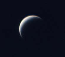
EnVision is a proposed orbital mission to Venus that would perform high-resolution radar mapping and atmospheric studies.[3][1] The mission would help scientists understand the relationships between its geological activity and the atmosphere, and it would investigate why Venus and Earth took such different evolutionary paths.
Overview
The concept was selected in May 2018 as a finalist to become the fifth Medium-class mission (M5) of the Cosmic Vision programme by the European Space Agency (ESA). The other two finalists are SPICA, an infrared space telescope, and THESEUS, a gamma-ray space observatory. The winner will be selected in 2021 and it would launch in 2032.[4][5]
If selected, EnVision would be launched on an Ariane 6.2 launch vehicle, giving a cruising time of about five months; after six months of aerobraking around Venus, it would begin a four-year mission at 259 km (161 mi) above Venus' surface.[4] EnVision would be capable of detecting centimeter-scale surface changes that would enable characterisation of volcanic and tectonic activity, and estimate rates of weathering and surface alteration.[1] The Subsurface Radar Sounder would image faults, stratigraphy and weathering in the upper ~100 m of the areas mapped, to identify structural relationships and geological history.[2] The mission cost is estimated at €544 million euros.[1]
Science goals
The core goal of EnVision is to detect activity and measure small-scale changes on Venus, including geological and geochemical cycles involving the interior, surface and atmosphere. The mission would repeatedly observe specific targets (~25% of the surface) with the widest possible range of measurements to fully characterise these areas.[2] Core science measurements are: high-resolution mapping of specific targets, surface change, geomorphology, topography, subsurface, thermal emission, SO
2, H
2O, D/H ratio, gravity, spin rate, and spin axis. The specific mission's goals are:[1]
- Determine the level and nature of current activity.
- Determine the sequence of geological events that generated its range of surface features.
- Assess whether Venus once had oceans or was hospitable for life.
- Understand the organising geodynamic framework that controls the release of internal heat over the history of the planet.
Science payload
The notional payload consists of three instruments:[1][2][4]
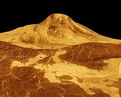
- Venus Synthetic Aperture Radar (VenSAR) operates at 3.2 GHz in the S band (9.4 cm wavelength) for spatial resolutions of 1 – 30 m.[6] Operating at a frequency below 30 MHz has the advantage that the signal penetrates the ground, providing information on subsurface structures that are crucial to understanding the history of Venus. A sounder in the 9-30 MHz range is able to penetrate to a crustal depth of 750–340 m respectively and image subsurface features at a vertical resolution of 5–16 m. An earlier version of the proposal intended to use spare parts produced for the Earth-orbiting Sentinel-1 satellite.[7]
- Venus Emissivity Mapper (VEM) suite consists of three channels: VEM-M, VEM-H and VEM-U.
VEM-M would provide compositional data on rock types; VEM-H would perform extremely high resolution atmospheric measurements; and VEM-U would monitor sulphured minor species (mainly SO and SO2) as well as the mysterious UV absorber in Venusian upper clouds. This suite would search for temporal variations in surface temperatures and tropospheric concentrations of volcanic gases, indicative of volcanic eruptions.
- Subsurface Radar Sounder (SRS) would image faults, stratigraphy and weathering in the upper ~100 m of the areas mapped by VenSAR, to identify structural relationships and geological history.
References
- 1 2 3 4 5 6 7 8 9 10 EnVision: Understanding why our most Earth-like neighbor is so different. M5 proposal. Richard Ghail. arXive.org
- 1 2 3 4 EnVision M5 Venus Orbiter Proposal: Opportunities and Challenges. (PDF). R. C. Ghail1, C. F. Wilson and T. Widemann. 47th Lunar and Planetary Science Conference (2016)
- ↑ "ESA selects three new mission concepts for study". Retrieved 10 May 2018.
- 1 2 3 New ESA Orbiter Might Explain Why Venus Went So Wrong. Bruce Dorminey, Forbes. 8 May 2018.
- ↑ ESA names space mission concepts in running for Cosmic Vision mission slot. David Szondy, New Atlas. 7 May 2018.
- ↑ EnVision: understanding why our most Earth-like neighbour is so different. Richard Ghail, Colin Wilson, Thomas Widemann, Lorenzo Bruzzone, Caroline Dumoulin, Jörn Helbert, Robbie Herrick, Emmanuel Marcq, Philippa Mason, Pascal Rosenblatt, Ann Carine Vandaele, Louis-Jerome Burtz. arXive.org; 27 Mar 2017.
- ↑ Ghail, R; EnVision Team (2012). "EnVision – where next for Venus?" (PDF). European Planetary Science Congress. Retrieved 2018-05-13.
|
|---|
|
| Geography | | |
|---|
| Moons | |
|---|
| Astronomy | |
|---|
| Exploration | | Past | |
|---|
| Current | |
|---|
| Planned | |
|---|
| Proposed | |
|---|
Proposed
manned | |
|---|
| Other | |
|---|
|
|---|
| Related | |
|---|
|
|
|---|
| Orbiters | | |
|---|
| Flybys | |
|---|
| Descent probes | |
|---|
| Landers | |
|---|
| Balloon probes | |
|---|
| Failed at launch | |
|---|
| Planned flybys | |
|---|
| Proposed | | Orbiters and probes | |
|---|
| Flybys | |
|---|
|
|---|
Cancelled and
undeveloped concepts | |
|---|
| Program overviews | |
|---|
| Related | |
|---|
- Italics indicates active current missions. † indicates failure en-route or before any data returned.
|
|
|---|
|
|
|---|
| Science | | Solar physics | |
|---|
| Planetary science | |
|---|
Astronomy and
cosmology | |
|---|
| Earth observation | |
|---|
|
|---|
| ISS spaceflight | |
|---|
|
| Telecommunications | |
|---|
Technology
demonstrators | |
|---|
| Cancelled and proposed | |
|---|
| Failed | |
|---|
Future missions in italics
|