European Organisation for the Exploitation of Meteorological Satellites
|
| |
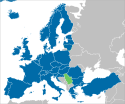 Member states Cooperating states | |
| Formation | 1986 |
|---|---|
| Headquarters | Darmstadt, Germany |
Membership | 30 member states |
Official language | English and French |
| Website | |
The European Organisation for the Exploitation of Meteorological Satellites (EUMETSAT) is an intergovernmental organisation created through an international convention agreed by a current total of 30 European Member States: Austria, Belgium, Bulgaria, Croatia, the Czech Republic, Denmark, Estonia, Finland, France, Germany, Greece, Hungary, Ireland, Iceland, Italy, Latvia, Lithuania, Luxembourg, the Netherlands, Norway, Poland, Portugal, Romania, Slovakia, Slovenia, Spain, Sweden, Switzerland, Turkey, and the United Kingdom. These States fund the EUMETSAT programs and are the principal users of the systems. The convention establishing EUMETSAT was opened for signature in 1983 and entered into force on 19 June 1986.
EUMETSAT's primary objective is to establish, maintain and exploit European systems of operational meteorological satellites. EUMETSAT is responsible for the launch and operation of the satellites and for delivering satellite data to end-users as well as contributing to the operational monitoring of climate and the detection of global climate changes.
The activities of EUMETSAT contribute to a global meteorological satellite observing system coordinated with other space-faring nations.
Satellite observations are an essential input to numerical weather prediction systems and also assist the human forecaster in the diagnosis of potentially hazardous weather developments. Of growing importance is the capacity of weather satellites to gather long-term measurements from space in support of climate change studies.
EUMETSAT is not part of the European Union, but became a signatory to the International Charter on Space and Major Disasters in 2012, thus providing for the global charitable use of its space assets.[1]
Member and cooperating states

Coordinates: 49°51′54″N 8°37′37″E / 49.86500°N 8.62694°E The national mandatory contributions of member states are proportional to their gross national income. However, the cooperating countries contribute only half of the fee they would pay for full membership.
Satellite programmes
Geostationary satellites
Two generations of active Meteosat geostationary satellites, Meteosat First Generation (MFG) and Meteosat Second Generation (MSG), provide images of the full Earth disc, and data for weather forecasts. More detail can be found on the Meteosat wiki.
Polar satellites
EUMETSAT Polar System
While geostationary satellites provide a continuous view of the earth disc from a stationary position in space, the instruments on polar-orbiting satellites, flying at a much lower altitude, provide more precise details about atmospheric temperature and moisture profiles, although with less frequent global coverage.
The lack of observational coverage in certain parts of the globe, particularly the Pacific Ocean and continents of the southern hemisphere, has led to the increasingly important role for polar-orbiting satellite data in numerical weather prediction and climate monitoring.
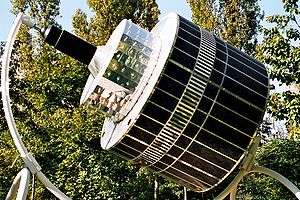
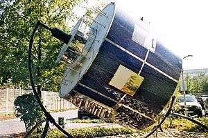
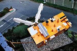
EUMETSAT Polar System (EPS) Metop mission consists of three polar orbiting Metop satellites, to be flown successively for more than 14 years. The first, Metop-A, was launched by a Russian Soyuz-2.1a rocket from Baikonur on October 19, 2006, at 22:28 Baikonur time (16:28 UTC). Metop-A was initially controlled by ESOC for the LEOP phase immediately following launch, with control handed over to EUMETSAT 72 hours after lift-off. EUMETSAT's first commands to the satellite were sent at 14:04 UTC on October 22, 2006.
The second EPS satellite, Metop-B, was launched from Baikonur on 17 September 2012,[2] with the third, Metop-C, scheduled for launch in October 2018[3].
Positioned at approximately 817 km above the Earth, special instruments on board Metop-A can deliver far more precise details about atmospheric temperature and moisture profiles than a geostationary satellite.
The satellites also ensure that the more remote regions of the globe, particularly in Northern Europe as well as the oceans in the Southern hemisphere, are fully covered.
The EPS programme is also the European half of a joint program with NOAA, called the International Joint Polar System. NOAA has operated a continuous series of low earth orbiting meteorological satellite since April 1960. Many of the instruments on Metop are also operated on NOAA/POES satellites, providing similar data types across the IJPS.
Instruments on Metop
- A/DCS (Advanced Data Collection System)
- AMSU-A1 and AMSU-A2
- ASCAT Advanced Scatterometer
- AVHRR (Advanced Very High Resolution Radiometer)
- GOME-2 (Global Ozone Monitoring Experiment) — instrument to monitor ozone levels
- GRAS (GNSS Receiver for Atmospheric Sounding: global navigation satellite systems radio occultation)
- HIRS (High Resolution Infrared Sounder)
- IASI (Infrared atmospheric sounding interferometer)
- MHS (Microwave Humidity Sounder)
- SARP-3 and SARR (Search And Rescue Processor and Search And Rescue Repeater)
- SEM (Space Environment Monitor)
Jason
The Jason-2 programme is an international partnership across multiple organisations, including EUMETSAT, CNES, and the US agencies NASA and NOAA.
Jason-2 was launched successfully from Vandenberg Air Force Base aboard a Delta-II rocket on 20 June 2008, 7:46 UTC.
Jason-2 reliably delivers detailed oceanographic data vital to our understanding of weather forecasting and climate change monitoring. Jason-2 provides data on the decadal (10-yearly) oscillations in large ocean basins, such as the Atlantic Ocean; mesoscale variability, and surface wind and wave conditions. Jason-2 measurements contribute to the European Centre for Medium-Range Weather Forecasts (ECMWF) satellite data assimilation, helping improve global atmosphere and ocean forecasting.
Altimetric data from Jason-2 have also helped create detailed decade-long global observations and analyses of the El Niño and La Niña phenomena, opening the way to new discoveries about ocean circulation and its effects on climate, and providing new insights into ocean tides, turbulent ocean eddies and marine gravity.
The next step is the Jason-3 Programme, which has been approved. It will ensure continuation of the series of measurements made by the Jason-2 satellite, and its predecessors, in support of meteorology, operational oceanography and, in particular, the monitoring of the sea-level trend, a key indicator of climate change.
See also
- EUMETNET
- the European Centre for Medium-Range Weather Forecasts (ECMWF)
- the French Centre National d'Etudes Spatiales (CNES)
- the US National Oceanic and Atmospheric Administration (NOAA), the US equivalent of EUMETSAT
- the US National Aeronautics and Space Administration (NASA), the US equivalent of the ESA
References
- ↑ "The International Charter : Space & Major Disasters" (PDF). Disasterscharter.org. Archived from the original (PDF) on 2013-11-11. Retrieved 2017-08-20.
- ↑ "At 18:28 CEST (22:28 Baikonur time), Metop-B was successfully launched from the Baikonur Cosmodrome in Kazakhstan on a Soyuz 2.1a rocket". EUMETSAT. Retrieved September 7, 2016.
- ↑ "General information on MetOP". EUMETSAT. Retrieved April 8, 2018.
External links
| Wikimedia Commons has media related to EUMETSAT. |
- EUMETSAT's Website
- EUMETSAT weather satellite viewer Online EUMETSAT weather satellite viewer with 2 months of archived data.