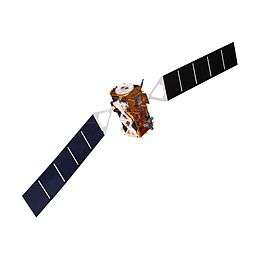
Sentinel-2
.jpg) Model of a Sentinel 2 satellite | |||
| Manufacturer | |||
|---|---|---|---|
| Operator | European Space Agency | ||
| Applications | Land and sea monitoring, natural disasters mapping, sea ice observations, ships detection | ||
| Specifications | |||
| Spacecraft type | Satellite | ||
| Bus | AstroBus-L | ||
| Constellation | 2 | ||
| Design life | 7 years | ||
| Launch mass | 1,140 kg (2,513 lb)[3] | ||
| Dry mass | 1,016 kg (2,240 lb)[3] | ||
| Dimensions | 3.4 × 1.8 × 2.35 m (11.2 × 5.9 × 7.7 ft)[3] | ||
| Power | 1,700 W[4] | ||
| Production | |||
| Status | Active | ||
| Built | 2 | ||
| On order | 2[2] | ||
| Launched | 2 | ||
| Operational | 2 | ||
| First launch |
Sentinel-2A 23 June 2015 | ||
| Last launch |
Sentinel-2B 7 March 2017 | ||
| |||
Sentinel-2 is an Earth observation mission developed by ESA as part of the Copernicus Programme to perform terrestrial observations in support of services such as forest monitoring, land cover changes detection, and natural disaster management. It consists of two identical satellites built by Airbus DS, Sentinel-2A and Sentinel-2B, with two additional satellites being constructed by Thales Alenia Space.
Overview
The Sentinel-2 mission has the following capabilities:
- Multi-spectral data with 13 bands in the visible, near infrared, and short wave infrared part of the spectrum
- Systematic global coverage of land surfaces from 56° S to 84° N, coastal waters, and all of the Mediterranean Sea
- Revisiting every 5 days under the same viewing angles. At high latitudes, Sentinel-2 swath overlap and some regions will be observed twice or more every 5 days, but with different viewing angles.
- Spatial resolution of 10 m, 20 m and 60 m
- 290 km field of view
- Free and open data policy
To achieve frequent revisits and high mission availability, two identical Sentinel-2 satellites (Sentinel-2A and Sentinel-2B) are planned to operate simultaneously. The planned orbit is Sun synchronous at 786 km (488 mi) altitude, 14.3 revolutions per day, with a 10:30 a.m. descending node. This local time was selected as a compromise between minimizing cloud cover and ensuring suitable Sun illumination. It is close to the Landsat local time and matches SPOT's, allowing the combination of Sentinel-2 data with historical images to build long-term time series.
Launch
The two satellites will work on opposite sides of the orbit. The launch of the first satellite, Sentinel-2A, occurred 23 June 2015 at 01:52 UTC on a Vega launch vehicle.[5] Sentinel-2B was launched on 7 March 2017 at 01:49 UTC,[6] also aboard a Vega rocket.[3]
On 15 December 2015, ESA contracted with Thales Alenia Space to build two additional satellites in the Sentinel-2 series, scheduled to launch starting in 2021.[2]
Instruments
The Sentinel-2 satellites will each carry a single multi-spectral instrument (MSI) with 13 spectral channels in the visible/near infrared (VNIR) and short wave infrared spectral range (SWIR).
This MSI imager uses a push-broom concept and its design has been driven by the large 290 km (180 mi) swath requirements, together with the high geometrical and spectral performance required of the measurements.[7] It has a 150 mm (6 in) aperture and a three-mirror anastigmat design with a focal length of about 600 mm (24 in); the instantaneous field of view is about 21 degrees by 3.5 degrees.[8] The mirrors are rectangular and made of silicon carbide, a similar technology to those on the Gaia mission.
| Sentinel-2 bands | Sentinel-2A | Sentinel-2B | |||
|---|---|---|---|---|---|
| Central wavelength (nm) | Bandwidth (nm) | Central wavelength (nm) | Bandwidth (nm) | Spatial resolution (m) | |
| Band 1 – Coastal aerosol | 443.9 | 27 | 442.3 | 45 | 60 |
| Band 2 – Blue | 496.6 | 98 | 492.1 | 98 | 10 |
| Band 3 – Green | 560.0 | 45 | 559 | 46 | 10 |
| Band 4 – Red | 664.5 | 38 | 665 | 39 | 10 |
| Band 5 – Vegetation red edge | 703.9 | 19 | 703.8 | 20 | 20 |
| Band 6 – Vegetation red edge | 740.2 | 18 | 739.1 | 18 | 20 |
| Band 7 – Vegetation red edge | 782.5 | 28 | 779.7 | 28 | 20 |
| Band 8 – NIR | 835.1 | 145 | 833 | 133 | 10 |
| Band 8A – Narrow NIR | 864.8 | 33 | 864 | 32 | 20 |
| Band 9 – Water vapour | 945 | 26 | 943.2 | 27 | 60 |
| Band 10 – SWIR – Cirrus | 1373.5 | 75 | 1376.9 | 76 | 60 |
| Band 11 – SWIR | 1613.7 | 143 | 1610.4 | 141 | 20 |
| Band 12 – SWIR | 2202.4 | 242 | 2185.7 | 238 | 20 |
Applications
Sentinel-2 will serve a wide range of applications related to Earth's land surface and coastal zones.
The mission will mainly provide information for agricultural and forestry practices and for helping manage food security. Satellite images will be used to determine various plant indices such as leaf area chlorophyll and water content indexes. This is particularly important for effective yield prediction and applications related to Earth’s vegetation.
As well as monitoring plant growth, Sentinel-2 can be used to map changes in land cover and to monitor the world's forests. It will also provide information on pollution in lakes and coastal waters. Images of floods, volcanic eruptions and landslides contribute to disaster mapping and help humanitarian relief efforts.
Examples for applications include:
- Monitoring land cover change for environmental monitoring
- Agricultural applications, such as crop monitoring and management to help food security
- Detailed vegetation and forest monitoring and parameter generation (e.g. leaf area index, chlorophyll concentration, carbon mass estimations)
- Observation of coastal zones (marine environmental monitoring, coastal zone mapping)
- Inland water monitoring
- Glacier monitoring, ice extent mapping, snow cover monitoring
- Flood mapping & management (risk analysis, loss assessment, disaster management during floods)
The Sentinel Monitoring web application offers an easy way to observe and analyse land changes based on archived Sentinel-2 data.[10]
Products
Sentinel-2's multi-spectral imager undertakes systematic acquisition in a single observation mode.[11]
- Level-1B: Top of atmosphere radiances in sensor geometry. Level-1B is composed of granules, one granule represents the sub-image one of the 12 detectors in the across track direction (25 km), and contains a given number of lines along track (approximately 23 km). Each Level-1B granule has a data volume of approximately 27 MB. Level-1B products require expert knowledge of orthorectification techniques.
- Level-1C: Top of atmosphere reflectances in fixed cartographic geometry (combined UTM projection and WGS84 ellipsoid). Level-1C images are a set of tiles of 100 km2, each of which is approximately 500 MB. These products contain applied radiometric and geometric corrections (including orthorectification and spatial registration).
- Level-2A: Bottom of atmosphere reflectances in cartographic geometry. This product is currently processed on the user side by using a processor running on ESA’s Sentinel-2 Toolbox. The possibility of making a standard core product systematically available from the Sentinels core ground segment is currently being assessed as part of the CSC evolution activities.
Training data sets
In June 2013, the Centre National d'Etudes Spatiales (CNES) released and distributed training data sets acquired by the SPOT 4 satellite with the same repetitivity as planned for Sentinel-2, to help future Sentinel-2 users develop methods and applications based on multitemporal data. This experiment, named SPOT4 (Take5), was held between February and June 2013, and provided time series over 45 sites for a variety of applications. To obtain this data set, the orbital altitude of SPOT4 was decreased by 2 kilometres (1.2 mi) in order to place it in a 5-day revisit cycle.[12]
This experiment was repeated with the SPOT 5 satellite, thanks to a co-funding from ESA and CNES, between April and September 2015. On this second experiment, 150 sites scattered all over the world have been observed.
The data from both experiments are freely available from the Spot (Take5) experiment site.[13]
Gallery
Examples of images taken.
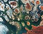 Lake Mackay, Australia, by Copernicus Sentinel-2B
 Central District, Botswana, by Copernicus Sentinel-2A
 Vojvodina, Serbia, by Copernicus Sentinel-2A
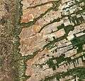 Central-eastern Brazil, by Copernicus Sentinel-2A
References
- 1 2 3 4 "Sentinel 2". Earth Online. European Space Agency. Retrieved 17 August 2014.
- 1 2 3 de Selding, Peter B. (15 December 2015). "Thales Alenia Inks Deal To Build 2 More Sentinel Satellites for ESA". SpaceNews. Retrieved 13 February 2018.
- 1 2 3 4 van Oene, Jacques (17 November 2016). "ESA's Sentinel 2B spacecraft steps into the spotlight". Spaceflight Insider. Retrieved 17 November 2016.
- ↑ "Sentinel-2 Data Sheet" (PDF). European Space Agency. August 2013. Retrieved 17 November 2016.
- ↑ Nowakowski, Tomasz (23 June 2015). "Arianespace successfully launches Europe's Sentinel-2A Earth observation satellite". Spaceflight Insider. Retrieved 17 August 2016.
- ↑ Bergin, Chris (6 March 2017). "Sentinel-2B rides Vega to join Copernicus fleet". NASASpaceFlight.com. Retrieved 9 March 2017.
- ↑ "Sentinel-2 MSI: Overview". European Space Agency. Retrieved 17 June 2015.
- ↑ Chorvalli, Vincent (9 October 2012). GMES Sentinel-2 MSI Telescope Alignment (PDF). International Conference on Space Optics. 9–12 October 2012. Ajaccio, France.
- ↑ "MultiSpectral Instrument (MSI) Overview". Sentinel Online. European Space Agency. Retrieved 10 August 2018.
- ↑ "Sentinel Monitoring". Sentinel Hub/Sinergise. Retrieved 26 August 2016.
- ↑ "Sentinel-2 MSI: Product Types". European Space Agency. Retrieved 17 June 2015.
- ↑ Hagolle, Olivier (28 November 2014). "Slides from the second SPOT (Take 5) Workshop". Séries Temporelles. Paul Sabatier University. Retrieved 23 April 2015.
- ↑ "Spot-Take5 Home". Spot-take5.org. Archived from the original on 7 October 2015.
External links
| Wikimedia Commons has media related to Sentinel 2. |
- Sentinel-2 at ESA
- Copernicus at ESA
- Sentinel-2 Mission Requirements Document
- Sentinel-2 data sheet
- SPOT (Take 5) data sets
| Sentinel satellites |
|  | |||||||
|---|---|---|---|---|---|---|---|---|---|
| Contributing missions |
| ||||||||
| |||||||||||||||
| |||||||||||||||
| Telecommunications |
| ||||||||||||||
Technology demonstrators | |||||||||||||||
| Cancelled and proposed | |||||||||||||||
| Failed | |||||||||||||||