European Data Relay System
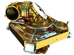 The Laser communication terminal of an EDRS satellite | |
| Mission type | Data transmission |
|---|---|
| Operator | German Aerospace Center |
| Website | http://www.esa.int/Our_Activities/Telecommunications_Integrated_Applications/EDRS |
The European Data Relay System (EDRS) system is a European constellation of state of the art GEO satellites that relay information and data between satellites, spacecraft, UAVs, and ground stations. The designers intend the system to provide almost full-time communication, even with satellites in low Earth orbit that often have reduced visibility from ground stations. It makes on-demand data available to, for example, rescue workers who want near-real-time satellite data of a crisis region.
The system has been developed as part of the ARTES 7 programme and is intended to be an independent, European satellite system that reduces time delays in the transmission of large quantities of data. The programme is similar to the American Tracking and Data Relay Satellite System that was set up to support the Space Shuttle—but EDRS is using a new generation Laser Communication Terminal (LCT) technology. The laser terminal transmits 1.8 Gbit/s across 45,000 km, the distance of a LEO-GEO link. Such a terminal was successfully tested during in-orbit verification between the German radar satellite TerraSAR-X and the American NFIRE satellite.[1] It is also embarked on the commercial telecommunication satellite Alphasat.[2]
Network
EDRS infrastructure will consist of two geostationary payloads (two further payloads are in the planning stage), a ground system consisting of a satellite control centre, a mission and operations centre, a feeder link ground station (FLGS), and data ground stations.
Space Segment
The first EDRS payload, EDRS-A, comprising a laser communication terminal and a Ka band inter-satellite link, was placed on-board Eutelsat commercial telecommunication satellite, called Eutelsat 9B. The satellite was launched in January 2016 by a Proton-M rocket and will be positioned at 9°E.[3][4]
A second dedicated spacecraft, EDRS-C, also carrying a laser communication terminal, will follow in 2018[5][6] and will be positioned at 31°E.[7] These two parts will form the initial core space infrastructure that provides direct coverage for LEO satellites over Europe, the Middle East, Africa, the Americas, Asia, and the Poles. Two further spacecraft are planned to complement the system from 2020 onwards, affording a complete coverage of the Earth and providing long-term system redundancy beyond 2030.
Ground Segment
The ground segment of EDRS includes three ground receiving stations located at Weilheim, Germany, Redu, Belgium and Harwell, UK. The prime Mission Operations Centre will be in Ottobrunn, Germany, while a backup centre will be installed in Redu, Belgium.[8]
The EDRS-A payload as well as the EDRS-C satellite will be operated by the German Space Operations Center (GSOC) of the German Aerospace Center in Oberpfaffenhofen near Munich, Germany.
Operations
The first users for EDRS will be the Sentinel-1 and -2 satellites of the Copernicus Programme (formerly the Global Monitoring for Environment and Security or GMES). The Sentinel satellites will provide data for the operational provision of geo-information products and services throughout Europe and the globe. EDRS will provide the data relay services for the Sentinel satellites facilitating a rapid downlink of large volumes of imagery. Extensive further capacities on the system will be available for third party users.
There are a number of key services that will benefit from this system's infrastructure:
- Earth Observation applications in support of time-critical and/or data-intensive services; e.g., change detection, environmental monitoring.
- Government and security services that need images from key European space systems such as Global Monitoring for Environment and Security.
- Emergency response and crisis intervention applications that need information and data over areas affected by natural or man-made disasters.
- Security forces that transmit data to Earth observation satellites, aircraft and unmanned aerial observation vehicles, to reconfigure such systems in real time.
- Weather satellite services that require the fast delivery of large quantities of data around the world.
Implementation
EDRS is being implemented as a Public Private Partnership (PPP) between the European Space Agency (ESA) and Airbus Defence & Space (ADS, former Astrium).[9] ESA funds the infrastructure development and is the anchor customer through the Sentinel satellite missions. ADS will carry the overall responsibility for the implementation of the space segment including launch, as well as the ground segment. ADS will then take over ownership of EDRS and will provide the data transmission services to ESA and customers worldwide.
See also
References
- ↑ TerraSAR-X NFIRE test
- ↑ Alphasat Archived 2009-12-23 at the Portuguese Web Archive
- ↑ "Lift-off for Europe's space laser network". bbc.com. 30 January 2016. Retrieved 30 January 2016.
- ↑ ILS to Launch Eutelsat 9B Satellite in 2015
- ↑ "Arianespace selected by Airbus Defence and Space to launch EDRS-C satellite". Arianespace. 19 March 2015. Retrieved 4 October 2015.
- ↑ "Europe's EDRS-C/Hylas-3 satellite launch set for early 2018". Space Intel Report. 15 April 2017. Retrieved 18 August 2017.
- ↑ Hauschildt, Harald (2012). "European Data Relay System – one year to go!" (PDF). International Conference on Space Optical Systems and Applications (ICSOS). Retrieved 2015-09-07.
- ↑ EDRS Operations Center
- ↑ EDRS: An independent data-relay system for Europe becoming reality
External links
| Wikimedia Commons has media related to European Data Relay System. |
| |||||||||||||||
| |||||||||||||||
| Telecommunications |
| ||||||||||||||
Technology demonstrators | |||||||||||||||
| Cancelled and proposed | |||||||||||||||
| Failed | |||||||||||||||